
| Memorials | : | 0 |
| Location | : | Bristol Unitary Authority, England |
| Phone | : | 01454 201935 |
| Website | : | www.almondsburyparishcouncil.gov.uk/ |
| Coordinate | : | 51.5589695, -2.5768189 |
frequently asked questions (FAQ):
-
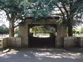
Where is Almondsbury Cemetery?
Almondsbury Cemetery is located at Tockington Ln, Lower, Almondsbury, Bristol Bristol Unitary Authority ,Bristol , BS32 4DZEngland.
-
Almondsbury Cemetery cemetery's updated grave count on graveviews.com?
0 memorials
-
Where are the coordinates of the Almondsbury Cemetery?
Latitude: 51.5589695
Longitude: -2.5768189
Nearby Cemetories:
1. Almondsbury Cemetery
Almondsbury, South Gloucestershire Unitary Authority, England
Coordinate: 51.5588230, -2.5760360
2. St Mary's Churchyard
Almondsbury, South Gloucestershire Unitary Authority, England
Coordinate: 51.5542300, -2.5733390
3. St. Mary the Virgin Churchyard
Olveston, South Gloucestershire Unitary Authority, England
Coordinate: 51.5828740, -2.5774290
4. All Saints Churchyard
Compton Greenfield, South Gloucestershire Unitary Authority, England
Coordinate: 51.5372800, -2.6201320
5. St Helen Churchyard
Alveston, South Gloucestershire Unitary Authority, England
Coordinate: 51.5850600, -2.5303380
6. St. John's Churchyard
Aust, South Gloucestershire Unitary Authority, England
Coordinate: 51.5991080, -2.6186160
7. St. Michael the Archangel Churchyard
Winterbourne, South Gloucestershire Unitary Authority, England
Coordinate: 51.5269000, -2.5183600
8. St Peter's Churchyard
Filton, South Gloucestershire Unitary Authority, England
Coordinate: 51.5102600, -2.5733100
9. Memorial Woodland Cemetery
Bristol Unitary Authority, England
Coordinate: 51.5754490, -2.5013060
10. Bristol Memorial Woodlands
Alveston, South Gloucestershire Unitary Authority, England
Coordinate: 51.5725340, -2.4983540
11. Thornbury Cemetery
Thornbury, South Gloucestershire Unitary Authority, England
Coordinate: 51.6099460, -2.5323000
12. St Mary the Virgin Parish Churchyard
Thornbury, South Gloucestershire Unitary Authority, England
Coordinate: 51.6132330, -2.5300090
13. St Mary the Virgin Churchyard
Henbury, Bristol Unitary Authority, England
Coordinate: 51.5063210, -2.6306320
14. St Peter's Churchyard
Frampton Cotterell, South Gloucestershire Unitary Authority, England
Coordinate: 51.5359115, -2.4801320
15. Mayshill Cemetery
South Gloucestershire Unitary Authority, England
Coordinate: 51.5562160, -2.4691663
16. Henbury Cemetery
Henbury, Bristol Unitary Authority, England
Coordinate: 51.5044590, -2.6414560
17. St James Parish Churchyard
Tytherington, South Gloucestershire Unitary Authority, England
Coordinate: 51.5932110, -2.4799250
18. Holy Trinity Churchyard
Westbury-on-Trym, Bristol Unitary Authority, England
Coordinate: 51.4939840, -2.6160070
19. Holy Trinity Churchyard
Horfield, Bristol Unitary Authority, England
Coordinate: 51.4879930, -2.5893570
20. Canford Cemetery and Crematorium
Westbury-on-Trym, Bristol Unitary Authority, England
Coordinate: 51.4946810, -2.6269490
21. St James the Less Churchyard
Iron Acton, South Gloucestershire Unitary Authority, England
Coordinate: 51.5490390, -2.4619310
22. St John the Baptist Churchyard
Frenchay, South Gloucestershire Unitary Authority, England
Coordinate: 51.4947700, -2.5205810
23. St. John the Evangelist Churchyard
Beachley, Forest of Dean District, England
Coordinate: 51.6184750, -2.6505640
24. Beachley Barracks Military Cemetery
Beachley, Forest of Dean District, England
Coordinate: 51.6185000, -2.6512000