
| Memorials | : | 0 |
| Location | : | Grayson County, USA |
| Coordinate | : | 33.6323000, -96.6132400 |
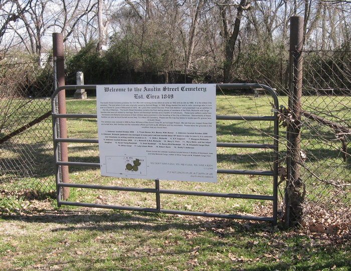
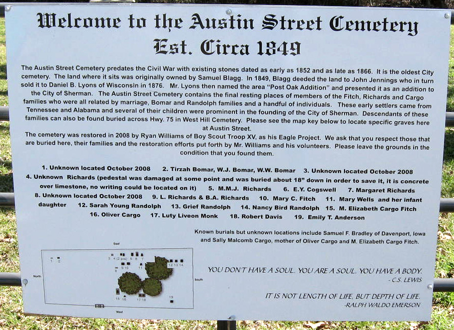
| Description | : | The Austin Street Cemetery predates the Civil War with existing stones dated as early as 1852 and as late as 1885. It is the oldest City cemetery. The land where it sits was originally owned by Samuel Blagg. In 1849, Blagg deeded the land to John Jennings who in turn sold it to Daniel B. Lyons of Wisconsin in 1876. Mr. Lyons then named the area “Post Oak Addition” and presented it as an addition to the City of Sherman. The Austin Street Cemetery contains the final resting places of members of the Fitch, Richards and Cargo families who were... Read More |
frequently asked questions (FAQ):
-
Where is Austin Street Cemetery?
Austin Street Cemetery is located at Grayson County ,Texas ,USA.
-
Austin Street Cemetery cemetery's updated grave count on graveviews.com?
0 memorials
-
Where are the coordinates of the Austin Street Cemetery?
Latitude: 33.6323000
Longitude: -96.6132400
Nearby Cemetories:
1. West Hill Cemetery
Sherman, Grayson County, USA
Coordinate: 33.6319008, -96.6194000
2. Saint Marys Cemetery
Sherman, Grayson County, USA
Coordinate: 33.6145706, -96.6026535
3. Forest Woodmen Circle Cemetery
Sherman, Grayson County, USA
Coordinate: 33.6355700, -96.6438100
4. Witten Cemetery
Sherman, Grayson County, USA
Coordinate: 33.6048180, -96.6087440
5. Cottonwood Cemetery
Sherman, Grayson County, USA
Coordinate: 33.6152800, -96.5723560
6. Grayson County Farm Cemetery
Sherman, Grayson County, USA
Coordinate: 33.6614609, -96.6480865
7. County Farm Cemetery
Grayson County, USA
Coordinate: 33.6615050, -96.6487230
8. Friendship Cemetery
Sherman, Grayson County, USA
Coordinate: 33.6344910, -96.6636734
9. Boyd Cemetery
Sherman, Grayson County, USA
Coordinate: 33.5737750, -96.6211460
10. Hendrix Cemetery
Sherman, Grayson County, USA
Coordinate: 33.6833330, -96.5775170
11. Akers Cemetery
Sherman, Grayson County, USA
Coordinate: 33.5671997, -96.5991974
12. Cedarlawn Memorial Park
Sherman, Grayson County, USA
Coordinate: 33.6947289, -96.5741501
13. Wimberly Family Cemetery
Sherman, Grayson County, USA
Coordinate: 33.6621100, -96.6927280
14. Keirsey Cemetery
Sherman, Grayson County, USA
Coordinate: 33.6949997, -96.6575012
15. Blue Creek Cemetery
Sherman, Grayson County, USA
Coordinate: 33.6361620, -96.5259250
16. Shannon Cemetery
Sherman, Grayson County, USA
Coordinate: 33.6845093, -96.5494766
17. Taylor Family Cemetery
Sherman, Grayson County, USA
Coordinate: 33.6729100, -96.5380700
18. Ellsworth Community Cemetery
Ellsworth, Grayson County, USA
Coordinate: 33.7045990, -96.5801240
19. Offutt Cemetery
Sherman, Grayson County, USA
Coordinate: 33.6760406, -96.6941223
20. Bethany Cemetery
Grayson County, USA
Coordinate: 33.6478004, -96.5167007
21. Iron Ore Cemetery
Denison, Grayson County, USA
Coordinate: 33.7102750, -96.5810680
22. Burleson Cemetery
Grayson County, USA
Coordinate: 33.5890007, -96.5250015
23. Luella Cemetery
Luella, Grayson County, USA
Coordinate: 33.5633011, -96.5524979
24. Loftin-McLain Cemetery
Denison, Grayson County, USA
Coordinate: 33.7143600, -96.5835100