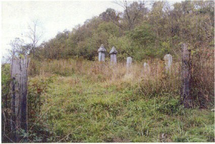
| Memorials | : | 10 |
| Location | : | Woodsfield, Monroe County, USA |
| Coordinate | : | 39.7313250, -81.1196140 |
| Description | : | The cemetery is located about 1300 feet west - southwest of the intersection Hilight Road (Ohio State Route 26) with Ohio State Route 800. The cemetery is located in Center Township, Monroe County, Ohio, and is # 8077 (Baker Cemetery / Steed Cemetery / Norris Cemetery) in “Ohio Cemeteries 1803-2003”, compiled by the Ohio Genealogical Society. The U.S. Geological Survey (USGS) Geographic Names Information System (GNIS) feature ID for the cemetery is 1076522 (Norris Cemetery). |
frequently asked questions (FAQ):
-
Where is Baker Cemetery?
Baker Cemetery is located at Hilight Road (Ohio State Road 26) Woodsfield, Monroe County ,Ohio , 43793USA.
-
Baker Cemetery cemetery's updated grave count on graveviews.com?
10 memorials
-
Where are the coordinates of the Baker Cemetery?
Latitude: 39.7313250
Longitude: -81.1196140
Nearby Cemetories:
1. Steed Cemetery
Monroe County, USA
Coordinate: 39.7314000, -81.1197000
2. Moffett Cemetery
Woodsfield, Monroe County, USA
Coordinate: 39.7228508, -81.0978851
3. Fairview Cemetery
Center Township, Monroe County, USA
Coordinate: 39.7139015, -81.1014023
4. Valley Cemetery
Woodsfield, Monroe County, USA
Coordinate: 39.7464700, -81.1426520
5. Saint Sylvester Catholic Church Cemetery
Woodsfield, Monroe County, USA
Coordinate: 39.7564621, -81.1176071
6. McGrary Cemetery
Woodsfield, Monroe County, USA
Coordinate: 39.7585983, -81.1299973
7. Moose Ridge Cemetery
Monroe County, USA
Coordinate: 39.7430992, -81.1544037
8. Neuhart Cemetery
Woodsfield, Monroe County, USA
Coordinate: 39.7462000, -81.0828000
9. Pioneer Cemetery
Woodsfield, Monroe County, USA
Coordinate: 39.7647018, -81.1175003
10. Drum Cemetery
Monroe County, USA
Coordinate: 39.7010994, -81.1414032
11. Cox-Gray-Myers Cemetery
Woodsfield, Monroe County, USA
Coordinate: 39.6967170, -81.1256170
12. Oaklawn Cemetery
Woodsfield, Monroe County, USA
Coordinate: 39.7663994, -81.1232986
13. Conners Ridge Cemetery
Monroe County, USA
Coordinate: 39.7016983, -81.1613998
14. Potts Cemetery
Monroe County, USA
Coordinate: 39.7588997, -81.1652985
15. Barber Ridge Cemetery
Wayne Township, Monroe County, USA
Coordinate: 39.7313995, -81.1819000
16. County Home Cemetery
Center Township, Monroe County, USA
Coordinate: 39.7806970, -81.1141560
17. Gillespie Cemetery
Monroe County, USA
Coordinate: 39.7528000, -81.0571976
18. Mount Carrick Cemetery
Mount Carrick, Monroe County, USA
Coordinate: 39.7494011, -81.0539017
19. Plainview Cemetery
Plainview, Monroe County, USA
Coordinate: 39.6781311, -81.1064987
20. Barnard Cemetery
Antioch, Monroe County, USA
Coordinate: 39.6750720, -81.1169730
21. Dougherty Cemetery
Monroe County, USA
Coordinate: 39.6767006, -81.1406021
22. Buchanan Presbyterian Church Cemetery
Summit Township, Monroe County, USA
Coordinate: 39.7678490, -81.1798325
23. Hope Ridge Cemetery
Monroe County, USA
Coordinate: 39.7902985, -81.1235962
24. Goudy Cemetery
Woodsfield, Monroe County, USA
Coordinate: 39.7503014, -81.0436020

