
| Memorials | : | 0 |
| Location | : | Tiel, Tiel Municipality, Netherlands |
| Coordinate | : | 51.8904900, 5.4273700 |
frequently asked questions (FAQ):
-
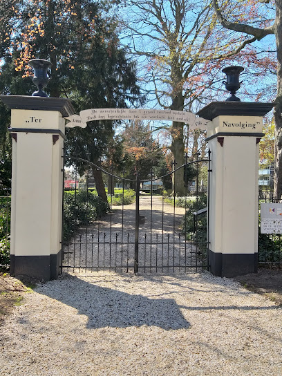
Where is Begraafplaats Ter Navolging?
Begraafplaats Ter Navolging is located at Tiel, Tiel Municipality ,Gelderland ,Netherlands.
-
Begraafplaats Ter Navolging cemetery's updated grave count on graveviews.com?
0 memorials
-
Where are the coordinates of the Begraafplaats Ter Navolging?
Latitude: 51.8904900
Longitude: 5.4273700
Nearby Cemetories:
1. Tiel Roman Catholic Cemetery
Tiel, Tiel Municipality, Netherlands
Coordinate: 51.8919400, 5.4298300
2. Joodse Begraafplaats
Tiel Municipality, Netherlands
Coordinate: 51.8907220, 5.4324720
3. Algemene Begraafplaats Zoelen en Kerk-Avezaath
Zoelen, Buren Municipality, Netherlands
Coordinate: 51.9064740, 5.3880700
4. Wadenoijen Protestant Churchyard
Wadenoijen, Tiel Municipality, Netherlands
Coordinate: 51.8737900, 5.3789300
5. Ophemert General Cemetery
Ophemert, Neerijnen Municipality, Netherlands
Coordinate: 51.8530200, 5.3965700
6. Buren Old General Cemetery
Buren, Buren Municipality, Netherlands
Coordinate: 51.9122100, 5.3298600
7. Joodse begraafplaats
Buren Municipality, Netherlands
Coordinate: 51.9125800, 5.3296490
8. R.K. Begraafplaats Buren
Buren, Buren Municipality, Netherlands
Coordinate: 51.9090374, 5.3216018
9. Maurik Roman Catholic Cemetery
Maurik, Buren Municipality, Netherlands
Coordinate: 51.9617100, 5.4302500
10. Joodse Begraafplaats
Geldermalsen Municipality, Netherlands
Coordinate: 51.8713890, 5.3025000
11. Geldermalsen General Cemetery
Geldermalsen, Geldermalsen Municipality, Netherlands
Coordinate: 51.8804000, 5.2984400
12. Algemene begraafplaats
Est, Neerijnen Municipality, Netherlands
Coordinate: 51.8496882, 5.3131190
13. Lienden General Cemetery
Lienden, Buren Municipality, Netherlands
Coordinate: 51.9513900, 5.5209200
14. Lith Rooms Katholiek Kerkhof
Lith, Oss Municipality, Netherlands
Coordinate: 51.8066300, 5.4383900
15. Buurmalsen General Cemetery
Buurmalsen, Geldermalsen Municipality, Netherlands
Coordinate: 51.8873500, 5.2817100
16. Joodse Begraafplaats Heijmanspad
Wijk bij Duurstede Municipality, Netherlands
Coordinate: 51.9709900, 5.3428500
17. Begraafplaats Meteren
Meteren, Geldermalsen Municipality, Netherlands
Coordinate: 51.8686615, 5.2737818
18. Beusichem Algemene Begraafplaats
Beusichem, Buren Municipality, Netherlands
Coordinate: 51.9482800, 5.2960800
19. Joodse Begraafplaats Steenstraat
Wijk bij Duurstede Municipality, Netherlands
Coordinate: 51.9757500, 5.3432200
20. Opijnen Protestant Churchyard
Opijnen, Neerijnen Municipality, Netherlands
Coordinate: 51.8280200, 5.3003800
21. Puiflijk Roman Catholic Cemetery
Puiflijk, Druten Municipality, Netherlands
Coordinate: 51.8788800, 5.5890700
22. Wijk-Bij-Duurstede General Cemetery
Wijk bij Duurstede, Wijk bij Duurstede Municipality, Netherlands
Coordinate: 51.9751800, 5.3388600
23. Elst General Cemetery
Elst, Rhenen Municipality, Netherlands
Coordinate: 51.9843400, 5.4978800
24. Algemene Begraafplaats
Rossum, Maasdriel Municipality, Netherlands
Coordinate: 51.8053361, 5.3233691