
| Memorials | : | 2 |
| Location | : | Elbert County, USA |
| Coordinate | : | 39.1352997, -104.4561005 |
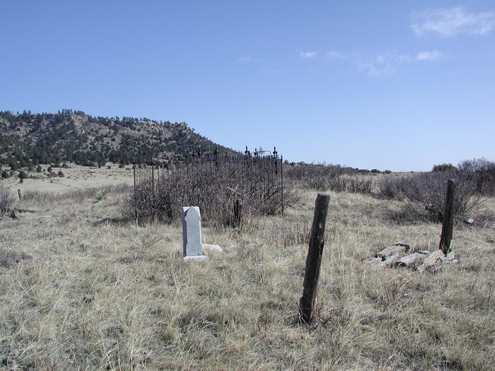
| Description | : | This is an old, small cemetery, located on private land in southern Elbert County, CO (T10N, R63W, Section 33, SW¼, NW¼). It appears on the USGS 7½-minute ‘Bijou Basin' topographic map. The cemetery is on the Kiowa Creek Ranch, which is part of Harmony Land & Cattle LLC, owned by John Malone of Denver. Access to the cemetery is allowed only with permission of the owner or manager of the ranch. The cemetery is located on top of a small hill and enclosed by barbed wire fence in an area of less than two acres. The grave... Read More |
frequently asked questions (FAQ):
-
Where is Bijou Basin Cemetery?
Bijou Basin Cemetery is located at Elbert County ,Colorado ,USA.
-
Bijou Basin Cemetery cemetery's updated grave count on graveviews.com?
2 memorials
-
Where are the coordinates of the Bijou Basin Cemetery?
Latitude: 39.1352997
Longitude: -104.4561005
Nearby Cemetories:
1. Peyton Cemetery
Peyton, El Paso County, USA
Coordinate: 39.0333710, -104.4878464
2. Bluff Cemetery
Eastonville, El Paso County, USA
Coordinate: 39.0999985, -104.5849991
3. Elbert Cemetery
Elbert, Elbert County, USA
Coordinate: 39.2291603, -104.5360870
4. National Slovak Society Cemetery
Calhan, El Paso County, USA
Coordinate: 39.0703011, -104.3161011
5. Saint Michaels Cemetery
Calhan, El Paso County, USA
Coordinate: 39.1180500, -104.2928000
6. Saint Mary Cemetery
Calhan, El Paso County, USA
Coordinate: 39.1180500, -104.2924000
7. Lenardt Cemetery
El Paso County, USA
Coordinate: 39.0900000, -104.3004000
8. James Cemetery
Elbert, Elbert County, USA
Coordinate: 39.1724892, -104.6196976
9. Scott Cemetery
Calhan, El Paso County, USA
Coordinate: 38.9980420, -104.4061970
10. Calhan Cemetery
Calhan, El Paso County, USA
Coordinate: 39.0335236, -104.3128815
11. Kiowa Old Cemetery
Kiowa, Elbert County, USA
Coordinate: 39.2962000, -104.5019000
12. Sakala Cemetery
Elbert County, USA
Coordinate: 39.1716995, -104.2482986
13. Eastonville Cemetery
Eastonville, El Paso County, USA
Coordinate: 39.0161018, -104.6061020
14. Boot Ranch Cemetery
Elbert, Elbert County, USA
Coordinate: 39.2742000, -104.5900000
15. Table Rock Cemetery
El Paso County, USA
Coordinate: 39.1182000, -104.6855000
16. Sproch Cemetery
Elbert County, USA
Coordinate: 39.1866989, -104.1977997
17. Myers Cemetery
Calhan, El Paso County, USA
Coordinate: 38.9893990, -104.2613983
18. Hungate Memorial
Kiowa, Elbert County, USA
Coordinate: 39.3467300, -104.4670100
19. Black Forest Lutheran Church Columbarium
Black Forest, El Paso County, USA
Coordinate: 39.0118000, -104.6988000
20. Ramah Cemetery
Ramah, El Paso County, USA
Coordinate: 39.1171913, -104.1629944
21. Rock Ridge Cemetery
Castle Rock, Douglas County, USA
Coordinate: 39.2572000, -104.7136000
22. Queen of Heaven Cemetery
Elizabeth, Elbert County, USA
Coordinate: 39.3637000, -104.5222000
23. Norton Cemetery
Elbert County, USA
Coordinate: 39.3022003, -104.2341995
24. LaForet Chapel Cemetery
Colorado Springs, El Paso County, USA
Coordinate: 39.0067470, -104.7186140