
| Memorials | : | 0 |
| Location | : | Buckfastleigh, Teignbridge District, England |
| Coordinate | : | 50.4917800, -3.7767600 |
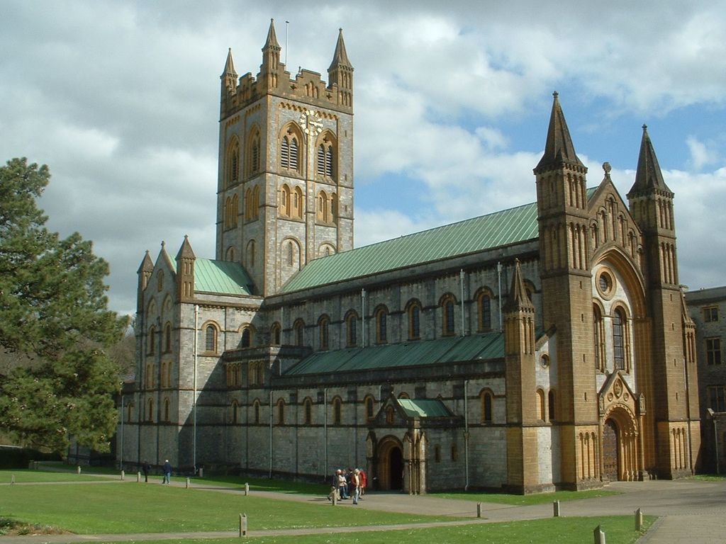
| Description | : | Buckfast Abbey forms part of an active Benedictine monastery at Buckfast, near Buckfastleigh, Devon, England. Buckfast first became home to an abbey in 1018. The first Benedictine abbey was followed by a Savignac (later Cistercian) abbey constructed on the site of the current abbey in 1134. The monastery was surrendered for dissolution in 1539, with the monastic buildings stripped and left as ruins, before being finally demolished. The former abbey site was used as a quarry, and later became home to a Gothic mansion house. In 1882 the site was purchased by a group of French Benedictine monks, who refounded a... Read More |
frequently asked questions (FAQ):
-
Where is Buckfast Abbey?
Buckfast Abbey is located at Buckfastleigh, Teignbridge District ,Devon , TQ11 0EEEngland.
-
Buckfast Abbey cemetery's updated grave count on graveviews.com?
0 memorials
-
Where are the coordinates of the Buckfast Abbey?
Latitude: 50.4917800
Longitude: -3.7767600
Nearby Cemetories:
1. Holy Trinity Churchyard
Buckfastleigh, Teignbridge District, England
Coordinate: 50.4852300, -3.7755900
2. St Andrew Churchyard
Ashburton, Teignbridge District, England
Coordinate: 50.5144940, -3.7572150
3. St Matthew's Churchyard
Landscove, South Hams District, England
Coordinate: 50.4842200, -3.7284000
4. St George the Martyr Churchyard
Dean Prior, South Hams District, England
Coordinate: 50.4578890, -3.7902140
5. St. Mary the Virgin Churchyard
Holne, South Hams District, England
Coordinate: 50.5108540, -3.8266340
6. Bidwell Woodland Natural Burial Ground
Rattery, South Hams District, England
Coordinate: 50.4418160, -3.7799990
7. St. Peter's Churchyard
Buckland-in-the-Moor, Teignbridge District, England
Coordinate: 50.5441800, -3.8070600
8. St. Mary's Churchyard
Dartington, South Hams District, England
Coordinate: 50.4511400, -3.7123700
9. St John the Baptist Churchyard. Leusdon
Newton Abbot, Teignbridge District, England
Coordinate: 50.5441200, -3.8228700
10. South Brent Church Cemetery
South Brent, South Hams District, England
Coordinate: 50.4283300, -3.8349000
11. St Mary the Virgin Churchyard
Denbury, Teignbridge District, England
Coordinate: 50.5075930, -3.6602590
12. St John the Baptist Church
Littlehempston, South Hams District, England
Coordinate: 50.4515000, -3.6741000
13. Totnes Priory
Totnes, South Hams District, England
Coordinate: 50.4318610, -3.6878700
14. St. Mary's Churchyard
Totnes, South Hams District, England
Coordinate: 50.4318190, -3.6877720
15. St. James's Churchyard
South Brent, South Hams District, England
Coordinate: 50.4112991, -3.8121303
16. St. Andrew Churchyard
Ipplepen, Teignbridge District, England
Coordinate: 50.4872610, -3.6443980
17. St Andrew Churchyard
Harberton, South Hams District, England
Coordinate: 50.4149440, -3.7209660
18. St. Pancras Churchyard
Widecombe-in-the-Moor, Teignbridge District, England
Coordinate: 50.5767810, -3.8109650
19. St. John the Evangelist
Bridgetown, South Hams District, England
Coordinate: 50.4295400, -3.6789000
20. St Bartholomew Parish Churchyard
Ogwell, Teignbridge District, England
Coordinate: 50.5188100, -3.6401400
21. St Mary's Churchyard
Diptford, South Hams District, England
Coordinate: 50.3966500, -3.7917300
22. St. Mary the Virgin Churchyard
Berry Pomeroy, South Hams District, England
Coordinate: 50.4368790, -3.6505430
23. Newton Abbot Cemetery
Newton Abbot, Teignbridge District, England
Coordinate: 50.5201180, -3.6200730
24. St Mary the Virgin Churchyard
Abbotskerswell, Teignbridge District, England
Coordinate: 50.5073360, -3.6147140