
| Memorials | : | 0 |
| Location | : | Gravdal, Vestvågøy kommune, Norway |
| Coordinate | : | 68.1171570, 13.5650470 |
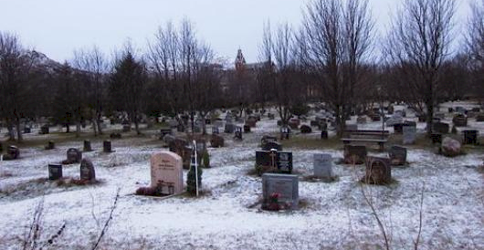
| Description | : | Buksnes Cemetery is the largest cemetery in Vestvågøy, and is located at the vicarage and the church at Bethesda. It was the only cemetery for Buksnes parish until the early 1900s. From the cemetery, the Buksnes Church can be seen in the background. Gravdal is a village in the municipality of Vestvågøy in Nordland county, Norway. It is located on the island of Vestvågøy in the central part of the Lofoten archipelago, north of the Arctic Circle. The village is situated along the shore of the Buksnes fjord. Gravdal translates, roughly, to "cemetery valley," and Vestvågøy... Read More |
frequently asked questions (FAQ):
-
Where is Buksnes Cemetery?
Buksnes Cemetery is located at Buksnes Road 450 / Buksnesveien 450 Gravdal, Vestvågøy kommune ,Nordland fylke , 8372Norway.
-
Buksnes Cemetery cemetery's updated grave count on graveviews.com?
0 memorials
-
Where are the coordinates of the Buksnes Cemetery?
Latitude: 68.1171570
Longitude: 13.5650470
Nearby Cemetories:
1. Petvik
Pettvika, Vestvågøy kommune, Norway
Coordinate: 68.1021850, 13.6560090
2. Flakstad Old Cemetery
Vareid, Flakstad kommune, Norway
Coordinate: 68.1044590, 13.2984600
3. Gimsøy Kirkegaard
Vågan kommune, Norway
Coordinate: 68.3205485, 14.2407991
4. Kabelvaag
Kabelvag, Vågan kommune, Norway
Coordinate: 68.2155210, 14.4788410
5. Svolvær Kirkegård
Svolvaer, Vågan kommune, Norway
Coordinate: 68.2434528, 14.5811509
6. Strandlandet Kirkegård
Laukvik i Lofoten, Vågan kommune, Norway
Coordinate: 68.3813976, 14.4690575
7. Sanden Kirkegård
Hadsel kommune, Norway
Coordinate: 68.4336537, 14.6077327
8. Steigen
Steigen, Steigen kommune, Norway
Coordinate: 67.9363540, 14.9793580
9. Duken
Bo i Vesteralen, Bø kommune, Norway
Coordinate: 68.6226250, 14.4371840
10. Hadsel Cemetery
Stokmarknes, Hadsel kommune, Norway
Coordinate: 68.5401200, 14.9895740
11. Skagen gamle Cemetery
Stokmarknes, Hadsel kommune, Norway
Coordinate: 68.5816850, 15.0112670
12. Skagen Nye
Stokmarknes, Hadsel kommune, Norway
Coordinate: 68.5819300, 15.0285790
13. Ora
Bo i Vesteralen, Bø kommune, Norway
Coordinate: 68.7426940, 14.6006420
14. Dalsand 1
Sortland, Sortland kommune, Norway
Coordinate: 68.6532370, 15.4928830
15. Dalsand 2
Sigerfjord, Sortland kommune, Norway
Coordinate: 68.6536880, 15.4920260
16. Sortland I
Sortland, Sortland kommune, Norway
Coordinate: 68.6982860, 15.4144810
17. Sortland II Kirke Gravplass
Sortland, Sortland kommune, Norway
Coordinate: 68.7004570, 15.4119250
18. Bodø Cemetery
Bodo, Bodø kommune, Norway
Coordinate: 67.2733150, 14.3837860
19. Selnes
Sortland, Sortland kommune, Norway
Coordinate: 68.7093270, 15.4061230
20. Bodin Cemetery
Bodo, Bodø kommune, Norway
Coordinate: 67.2753500, 14.4365100
21. Steinlandsfjorden Kirkegård
Øksnes kommune, Norway
Coordinate: 68.8090191, 15.1886369
22. Øksnes Church Cemetery
Breidstrand, Øksnes kommune, Norway
Coordinate: 68.8775071, 14.9716038
23. Røsvik Old Cemetery
Rosvik, Sørfold kommune, Norway
Coordinate: 67.4808430, 15.4679960
24. Saltstraumen Cemetery
Knapplund, Bodø kommune, Norway
Coordinate: 67.2325300, 14.6279100