
| Memorials | : | 0 |
| Location | : | Marshall County, USA |
| Coordinate | : | 33.9839516, -96.8873978 |
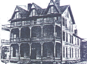
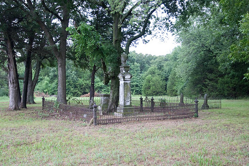
| Description | : | Section 4, T6S,R6e The Cemetery is located aobut one and a half miles east of Lebanon. The cemetery was adjacent to Burney Institute. The Burney Institute was established in 1854 by the Chickasaw Council as a school for Chickasaw girls. The name was changed to Chickasaw Orphan Home and Manual Labor School in 1887. In 2006 the Chickasaw tribe repurchased the cemetery and are restoring it. |
frequently asked questions (FAQ):
-
Where is Burney Institute Cemetery?
Burney Institute Cemetery is located at Marshall County ,Oklahoma ,USA.
-
Burney Institute Cemetery cemetery's updated grave count on graveviews.com?
0 memorials
-
Where are the coordinates of the Burney Institute Cemetery?
Latitude: 33.9839516
Longitude: -96.8873978


Nearby Cemetories:
1. Lebanon Cemetery
Lebanon, Marshall County, USA
Coordinate: 33.9876404, -96.9104233
2. Powell Cemetery
Powell, Marshall County, USA
Coordinate: 33.9536700, -96.8698200
3. Keel Cemetery
Madill, Marshall County, USA
Coordinate: 34.0330400, -96.9070270
4. I. Hunter Pickens Cemetery
Marshall County, USA
Coordinate: 34.0385510, -96.9400440
5. Enville Cemetery
Enville, Love County, USA
Coordinate: 33.9830894, -96.9800186
6. Graveyard Bluff Cemetery
Love County, USA
Coordinate: 33.9542740, -96.9764470
7. Wright Cemetery
Enville, Love County, USA
Coordinate: 34.0088005, -96.9903107
8. Wallace Cemetery
McMillan, Marshall County, USA
Coordinate: 34.0699910, -96.9301240
9. Howard Cemetery
Dexter, Cooke County, USA
Coordinate: 33.9114532, -96.9749451
10. Shay Cemetery
Shay, Marshall County, USA
Coordinate: 33.9281006, -96.7780991
11. Willis Cemetery
Willis, Marshall County, USA
Coordinate: 33.8849800, -96.8341400
12. McMillan Cemetery
McMillan, Marshall County, USA
Coordinate: 34.0847015, -96.9364014
13. Pickens Cemetery
McMillan, Marshall County, USA
Coordinate: 34.0722200, -96.9661100
14. Ran Cemetery
Enville, Love County, USA
Coordinate: 34.0155983, -97.0201416
15. Mount Zion Cemetery
Grayson County, USA
Coordinate: 33.8694000, -96.9246979
16. Legate Cemetery
Hoxbar, Love County, USA
Coordinate: 34.0583000, -97.0117035
17. Noel Cemetery
Grayson County, USA
Coordinate: 33.8592550, -96.8246660
18. Madill Cemetery
Madill, Marshall County, USA
Coordinate: 34.0712200, -96.7574700
19. Woodberry Forest Cemetery
Madill, Marshall County, USA
Coordinate: 34.0755997, -96.7602997
20. Wilson Creek Cemetery
Carter County, USA
Coordinate: 34.1000750, -96.9812160
21. Johnson Cemetery
Grayson County, USA
Coordinate: 33.8544510, -96.8223380
22. Old Oakland Cemetery
Oakland, Marshall County, USA
Coordinate: 34.0994700, -96.7894000
23. Kingston Cemetery
Kingston, Marshall County, USA
Coordinate: 34.0022300, -96.7175900
24. Loves Valley Cemetery
Love County, USA
Coordinate: 33.8746000, -97.0015200