
| Memorials | : | 1 |
| Location | : | Burlington, Boone County, USA |
| Coordinate | : | 39.0196991, -84.7241974 |
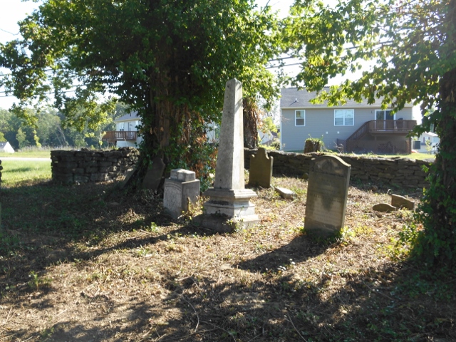
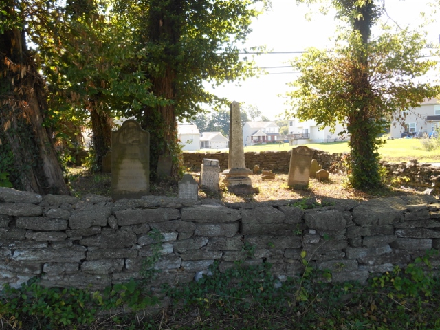
| Description | : | This cemetery is located on the west side of East Bend Road (Kentucky State Route 338) about 0.2 miles south of its intersection with Allens Fork Drive. The U.S. Geological Survey (USGS) Geographic Names Information System (GNIS) feature ID for the cemetery is 489322 (Chambers Cemetery). The Boone County GIS unique ID assigned to this cemetery is 41 (Chambers Cemetery). The cemetery has an index number of 42 (Chambers) on the Boone County Kentucky Cemetery Map published in 2005 by the Boone County Planning Commission in conjunction with Johnson-Wilson Cemetery Stewards Association. The cemetery is not identified separately but is combined into Hamilton/Chambers Cemetery... Read More |
frequently asked questions (FAQ):
-
Where is Chambers Cemetery?
Chambers Cemetery is located at East Bend Road Burlington, Boone County ,Kentucky , 41005USA.
-
Chambers Cemetery cemetery's updated grave count on graveviews.com?
1 memorials
-
Where are the coordinates of the Chambers Cemetery?
Latitude: 39.0196991
Longitude: -84.7241974
Nearby Cemetories:
1. Caldwell Cemetery
Burlington, Boone County, USA
Coordinate: 39.0205560, -84.7241670
2. Tandy Cemetery
Burlington, Boone County, USA
Coordinate: 39.0225000, -84.7222220
3. Burlington IOOF Cemetery
Burlington, Boone County, USA
Coordinate: 39.0253983, -84.7154999
4. Old Burlington Cemetery
Burlington, Boone County, USA
Coordinate: 39.0319444, -84.7233333
5. Potters Field Cemetery
Burlington, Boone County, USA
Coordinate: 39.0341670, -84.7319440
6. Underhill Cemetery
Burlington, Boone County, USA
Coordinate: 39.0027780, -84.7188890
7. Johnson-Wilson Cemetery
Burlington, Boone County, USA
Coordinate: 39.0299150, -84.7434200
8. Boone County Infirmary Cemetery
Burlington, Boone County, USA
Coordinate: 39.0350560, -84.7384820
9. Churchill Clore Family Cemetery
Burlington, Boone County, USA
Coordinate: 39.0106710, -84.7466150
10. Rouse-Utz Cemetery
Burlington, Boone County, USA
Coordinate: 39.0372220, -84.7127780
11. White Family Cemetery
Burlington, Boone County, USA
Coordinate: 39.0158330, -84.7522220
12. Utz Cemetery
Burlington, Boone County, USA
Coordinate: 39.0414170, -84.7177350
13. Utz Slave Cemetery
Burlington, Boone County, USA
Coordinate: 39.0416670, -84.7172220
14. Clore-Weaver Cemetery
Burlington, Boone County, USA
Coordinate: 39.0009340, -84.7048250
15. Zinn Cemetery
Burlington, Boone County, USA
Coordinate: 39.0447220, -84.7183330
16. E Rouse Cemetery (Defunct)
Hebron, Boone County, USA
Coordinate: 39.0316670, -84.6869440
17. Duncan Cemetery
Burlington, Boone County, USA
Coordinate: 39.0478230, -84.7459560
18. A.S. Crisler Cemetery
Florence, Boone County, USA
Coordinate: 38.9916590, -84.7020550
19. Snyder-Crisler Cemetery
Burlington, Boone County, USA
Coordinate: 38.9867750, -84.7183080
20. Crisler Family Cemetery
Burlington, Boone County, USA
Coordinate: 38.9858330, -84.7230560
21. Aylor Cemetery (Defunct)
Florence, Boone County, USA
Coordinate: 39.0169973, -84.6793854
22. William Aylor Cemetery (Defunct)
Florence, Boone County, USA
Coordinate: 39.0203480, -84.6778680
23. Elizabeth Utz Cemetery
Oakbrook, Boone County, USA
Coordinate: 38.9839850, -84.7122910
24. Aylor Cemetery
Limaburg, Boone County, USA
Coordinate: 38.9830570, -84.7177780