
| Memorials | : | 3 |
| Location | : | Williamstown, Jefferson County, USA |
| Coordinate | : | 39.0766780, -95.2572680 |
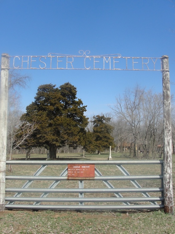
| Description | : | Chester Cemetery is located in rural countryside near Chester School, in Sarcoxie Township, Jefferson County, Kansas, on Republic Road, approx. 8 miles north of Lawrence, Douglas County, Kansas. An actively-used graveyard in bygone years, Chester Cemetery in modern times has numerous unmarked graves. Without regular cemetery maintenance, some tombstones (wooden and sandstone) unfortunately deteriorated, crumbled or sank into the soil, after constant exposure to weathering elements and to mischievous vandalism. General directions for Chester Cemetery, travelling from Lawrence, Kansas. Follow Massachusetts Street northward beyond junction with Interstate 70 (Kansas Turnpike), onto conjoined U.S. Highways 59 & 24, turn right on... Read More |
frequently asked questions (FAQ):
-
Where is Chester Cemetery?
Chester Cemetery is located at 1784 Republic Road Williamstown, Jefferson County ,Kansas , 66073USA.
-
Chester Cemetery cemetery's updated grave count on graveviews.com?
3 memorials
-
Where are the coordinates of the Chester Cemetery?
Latitude: 39.0766780
Longitude: -95.2572680
Nearby Cemetories:
1. Hardy Oak Cemetery
McLouth, Jefferson County, USA
Coordinate: 39.1166992, -95.2474976
2. Underwood Cemetery
Perry, Jefferson County, USA
Coordinate: 39.0661011, -95.3116989
3. Holliday Cemetery
Williamstown, Jefferson County, USA
Coordinate: 39.0438995, -95.3386002
4. Lakeview Cemetery
Douglas County, USA
Coordinate: 39.0219100, -95.3164400
5. Pony Creek Cemetery
Leavenworth County, USA
Coordinate: 39.0730500, -95.1594400
6. Maple Grove Cemetery
Lawrence, Douglas County, USA
Coordinate: 39.0018997, -95.2316971
7. Adams Cemetery
Douglas County, USA
Coordinate: 38.9955400, -95.2509100
8. Billy C. Chrisman Gravesite
Oskaloosa, Jefferson County, USA
Coordinate: 39.1404900, -95.3291900
9. Buster Cemetery
Perry, Jefferson County, USA
Coordinate: 39.1286011, -95.3443985
10. Lyon Family Cemetery
Lawrence, Douglas County, USA
Coordinate: 38.9877440, -95.3166530
11. Mount Calvary Cemetery
Perry, Jefferson County, USA
Coordinate: 39.0917015, -95.3902969
12. Oak Ridge Cemetery
Perry, Jefferson County, USA
Coordinate: 39.0901527, -95.3911514
13. Bald Eagle Cemetery
Lecompton, Douglas County, USA
Coordinate: 39.0461830, -95.3868310
14. Davis Cemetery
Lawrence, Douglas County, USA
Coordinate: 38.9722500, -95.2831100
15. Trinity Episcopal Church Columbarium
Lawrence, Douglas County, USA
Coordinate: 38.9653893, -95.2373886
16. Reno Cemetery
Reno, Leavenworth County, USA
Coordinate: 39.0505600, -95.1165237
17. Wild Horse Cemetery
McLouth, Jefferson County, USA
Coordinate: 39.1801796, -95.1968307
18. Moore Grave Site
Lecompton, Douglas County, USA
Coordinate: 39.0449500, -95.3978300
19. Pioneer Cemetery
Lecompton, Douglas County, USA
Coordinate: 39.0378456, -95.3971863
20. Dyche Hall Natural History Museum
Lawrence, Douglas County, USA
Coordinate: 38.9584800, -95.2434800
21. Tonganoxie Cemetery
Tonganoxie, Leavenworth County, USA
Coordinate: 39.1093559, -95.1092987
22. McLouth Cemetery
McLouth, Jefferson County, USA
Coordinate: 39.1940727, -95.2149429
23. Oak Hill Cemetery
Lawrence, Douglas County, USA
Coordinate: 38.9589005, -95.2118988
24. Mount Calvary Catholic Cemetery
Lawrence, Douglas County, USA
Coordinate: 38.9580002, -95.2139969