
| Memorials | : | 0 |
| Location | : | Gooding County, USA |
| Coordinate | : | 42.9266000, -114.9841000 |
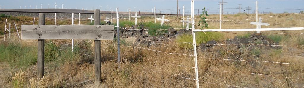
| Description | : | Chinese who were working as section hands on the Railroad. The Chinese had played a significant part in the construction of the railroad. During the construction of 1883 The Chinamen were killed by an dynamite explosion. They were buried by the Rail line near Bliss Idaho. Located near the Bliss Rodeo Grounds. |
frequently asked questions (FAQ):
-
Where is Chinese Memorial Cemetery?
Chinese Memorial Cemetery is located at Gooding County ,Idaho ,USA.
-
Chinese Memorial Cemetery cemetery's updated grave count on graveviews.com?
0 memorials
-
Where are the coordinates of the Chinese Memorial Cemetery?
Latitude: 42.9266000
Longitude: -114.9841000
Nearby Cemetories:
1. Pioneer Cemetery
Bliss, Gooding County, USA
Coordinate: 42.9227982, -114.9443970
2. Bliss Family Cemetery
Bliss, Gooding County, USA
Coordinate: 42.9084900, -114.9497800
3. Lower Clover Creek Cemetery
Bliss, Gooding County, USA
Coordinate: 43.0229100, -115.0456200
4. Upper Clover Creek Cemetery
Bliss, Gooding County, USA
Coordinate: 43.0297000, -114.9458000
5. Hagerman Pioneer Cemetery
Hagerman, Gooding County, USA
Coordinate: 42.8298000, -114.9040000
6. Hagerman Cemetery
Hagerman, Gooding County, USA
Coordinate: 42.8230500, -114.8902810
7. King Hill Cemetery
King Hill, Elmore County, USA
Coordinate: 42.9975610, -115.2239060
8. Elmwood Cemetery
Gooding, Gooding County, USA
Coordinate: 42.9308014, -114.7011032
9. Pioneer Cemetery
Gooding, Gooding County, USA
Coordinate: 42.9324989, -114.6931000
10. Glenn Rest Cemetery
Glenns Ferry, Elmore County, USA
Coordinate: 42.9551700, -115.3147500
11. Wendell Cemetery
Wendell, Gooding County, USA
Coordinate: 42.7734160, -114.7111700
12. Church of God in Christ Mennonite Cemetery
Buhl, Twin Falls County, USA
Coordinate: 42.5942000, -114.8307000
13. Snake River Canyon National Cemetery
Buhl, Twin Falls County, USA
Coordinate: 42.6016979, -114.7586136
14. West End Cemetery
Buhl, Twin Falls County, USA
Coordinate: 42.6008380, -114.7366730
15. Manard Cemetery
Fairfield, Camas County, USA
Coordinate: 43.2675018, -114.7463989
16. Hill City Cemetery
Camas County, USA
Coordinate: 43.3081017, -115.0457993
17. Jerome Cemetery
Jerome, Jerome County, USA
Coordinate: 42.7141400, -114.5299500
18. Barbara Ann Morgan Gravesite
Twin Falls County, USA
Coordinate: 42.5768970, -114.7119550
19. Valley View Mennonite Church Cemetery
Twin Falls County, USA
Coordinate: 42.5670000, -114.6745000
20. Shoshone Cemetery
Shoshone, Lincoln County, USA
Coordinate: 42.9388270, -114.3879960
21. Filer Cemetery
Filer, Twin Falls County, USA
Coordinate: 42.5778008, -114.5847015
22. Corral Cemetery
Fairfield, Camas County, USA
Coordinate: 43.3857994, -114.9431000
23. Clover Lutheran Cemetery
Clover, Twin Falls County, USA
Coordinate: 42.5133000, -114.6893000
24. Monastery of the Ascension Cemetery
Jerome, Jerome County, USA
Coordinate: 42.7067000, -114.4162000