
| Memorials | : | 0 |
| Location | : | Keyesport, Clinton County, USA |
| Coordinate | : | 38.7339172, -89.3852386 |
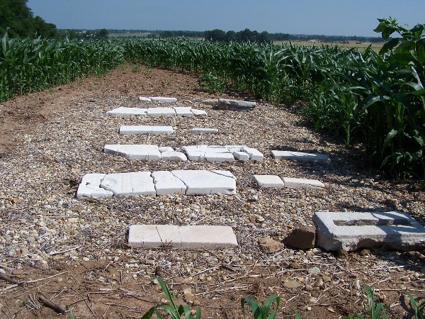
| Description | : | Wheatfield Township - NWSW1 T3N R3W Clinton County, Illinois Take Kell Road north to where the road stops going at an angle and returns to straight north. There is a farm lane on the east side that goes up Grube Hill. The cemetery is in the field over the crest of the hill, about a block straight east from where the farm lane driveway ends. The remnants of the cemetery stones have been lovingly restored with black landscaping cloth topped with creek bed pebbles with the pieces of tombstones lying flat on top of the pebbles like pieces of a jigsaw puzzle. |
frequently asked questions (FAQ):
-
Where is Cole Family Cemetery?
Cole Family Cemetery is located at Keyesport, Clinton County ,Illinois ,USA.
-
Cole Family Cemetery cemetery's updated grave count on graveviews.com?
0 memorials
-
Where are the coordinates of the Cole Family Cemetery?
Latitude: 38.7339172
Longitude: -89.3852386
Nearby Cemetories:
1. Bowen Graveyard
Jamestown, Clinton County, USA
Coordinate: 38.7231000, -89.4029000
2. Beaver Creek Baptist Church Cemetery
Marydale, Clinton County, USA
Coordinate: 38.7117340, -89.4071140
3. Wisetown Cemetery
Beaver Creek, Bond County, USA
Coordinate: 38.7627983, -89.4021988
4. Noe Graveyard
Keyesport, Clinton County, USA
Coordinate: 38.7225000, -89.3398000
5. Godell Graveyard
Marydale, Clinton County, USA
Coordinate: 38.7045060, -89.4167380
6. Gillespie Cemetery
New Memphis, Clinton County, USA
Coordinate: 38.7350006, -89.3308029
7. McKendree Chapel Cemetery
Keyesport Landing, Bond County, USA
Coordinate: 38.7428017, -89.3277969
8. Yingst Cemetery
Carlyle, Clinton County, USA
Coordinate: 38.6828003, -89.3964005
9. Camp Ground Cemetery
Greenville, Bond County, USA
Coordinate: 38.7960014, -89.4094009
10. Saint Felicitas Cemetery
Wheatfield Township, Clinton County, USA
Coordinate: 38.6966782, -89.4560776
11. Saint Peter Lutheran Church Cemetery
Stolletown, Clinton County, USA
Coordinate: 38.6876400, -89.4471000
12. McNeill Cemetery
Keyesport, Clinton County, USA
Coordinate: 38.7167015, -89.2891998
13. Keyesport City Cemetery
Keyesport, Clinton County, USA
Coordinate: 38.7368011, -89.2760010
14. Poor Farm Cemetery
Carlyle, Clinton County, USA
Coordinate: 38.6463970, -89.3730710
15. Rudolph Cemetery
Stolletown, Clinton County, USA
Coordinate: 38.6674995, -89.4608002
16. Burnside Cemetery
Carlyle, Clinton County, USA
Coordinate: 38.6646000, -89.3118000
17. Greene Cemetery
Pierron, Bond County, USA
Coordinate: 38.7849998, -89.4824982
18. Shoal Creek Baptist Church Cemetery
Jamestown, Clinton County, USA
Coordinate: 38.7031034, -89.4986946
19. Baker Cemetery
Saint Rose, Clinton County, USA
Coordinate: 38.7231000, -89.5104000
20. Jamestown Cemetery
Jamestown, Clinton County, USA
Coordinate: 38.7349014, -89.5120010
21. Jackson Cemetery
Jamestown, Clinton County, USA
Coordinate: 38.7333000, -89.5124000
22. Duncan Cemetery
Tamalco, Bond County, USA
Coordinate: 38.7710991, -89.2643967
23. Hills Fort Memorial
Pocahontas, Bond County, USA
Coordinate: 38.8138008, -89.4660034
24. Saint Peters Cemetery
Hookdale, Bond County, USA
Coordinate: 38.8149986, -89.2941971