
| Memorials | : | 0 |
| Location | : | Dudleytown, Jackson County, USA |
| Coordinate | : | 38.8264885, -85.9044418 |
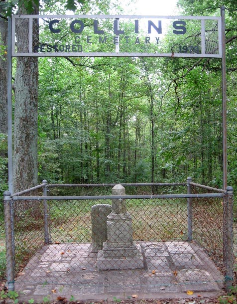
| Description | : | Now known as the "Collins Cemetery", this pioneer burial ground was located on a beautiful knoll sloping to the west in Washington Township about 1 3/4 mile south of Dudleytown on County Road 730E and about 1/4 mile west. In a 1970 restoration project all the remaining stones and markers were gathered together and placed in a 10' x 10' plot with a fence around it. The cemetery sign is visible from the road when there are no crops growing in the field between it and the road. According to Thomas Collins who was buried there,... Read More |
frequently asked questions (FAQ):
-
Where is Collings Cemetery?
Collings Cemetery is located at Dudleytown, Jackson County ,Indiana ,USA.
-
Collings Cemetery cemetery's updated grave count on graveviews.com?
0 memorials
-
Where are the coordinates of the Collings Cemetery?
Latitude: 38.8264885
Longitude: -85.9044418
Nearby Cemetories:
1. Mount Pleasant Cemetery
Tampico, Jackson County, USA
Coordinate: 38.8143997, -85.9119034
2. Blair-Johnson Family Cemetery
Jackson County, USA
Coordinate: 38.8099400, -85.9218370
3. Emanuel Lutheran Cemetery
Dudleytown, Jackson County, USA
Coordinate: 38.8487167, -85.9010773
4. Crothersville Cemetery
Crothersville, Jackson County, USA
Coordinate: 38.7943700, -85.8529000
5. Saint Johns Lutheran Church Cemetery
Seymour, Jackson County, USA
Coordinate: 38.8650169, -85.9523087
6. Grassy Cemetery
Crothersville, Jackson County, USA
Coordinate: 38.8223400, -85.8318300
7. Rucker Cemetery
Grassy Fork Township, Jackson County, USA
Coordinate: 38.8119011, -85.9768982
8. Russell Chapel Cemetery
Tampico, Jackson County, USA
Coordinate: 38.7783012, -85.9468994
9. First German Reformed Cemetery
Crothersville, Jackson County, USA
Coordinate: 38.7935880, -85.8421700
10. Chestnut Ridge Cemetery
Dudleytown, Jackson County, USA
Coordinate: 38.8843994, -85.8855972
11. Lubker Cemetery
Jackson County, USA
Coordinate: 38.8231010, -85.9839020
12. Johnson-King Cemetery
Uniontown, Jackson County, USA
Coordinate: 38.8581490, -85.8320830
13. Bedel Cemetery
Uniontown, Jackson County, USA
Coordinate: 38.8652830, -85.8375390
14. Uniontown Cemetery
Uniontown, Jackson County, USA
Coordinate: 38.8418200, -85.8232800
15. Spall Cemetery
Uniontown, Jackson County, USA
Coordinate: 38.8638590, -85.8319600
16. Bethany Baptist Church Cemetery
Crothersville, Jackson County, USA
Coordinate: 38.7643204, -85.8592834
17. Drier Cemetery
Wegan, Jackson County, USA
Coordinate: 38.8489930, -85.9918040
18. Stewart Cemetery
Uniontown, Jackson County, USA
Coordinate: 38.8377610, -85.8135680
19. New Hope Cemetery
Uniontown, Jackson County, USA
Coordinate: 38.8597480, -85.8202990
20. Gorrell Cemetery
Crothersville, Jackson County, USA
Coordinate: 38.8031006, -85.8143997
21. Marling Cemetery
Uniontown, Jackson County, USA
Coordinate: 38.8708440, -85.8193810
22. Moore Cemetery
Jackson County, USA
Coordinate: 38.9058849, -85.8800927
23. Pierson Family Cemetery
Pleasantville, Jackson County, USA
Coordinate: 38.7907970, -85.8073740
24. Steep Hollow Cemetery
Crothersville, Jackson County, USA
Coordinate: 38.7437000, -85.8875000