| Memorials | : | 3 |
| Location | : | Council Bluffs, Pottawattamie County, USA |
| Coordinate | : | 41.2265560, -95.8187100 |
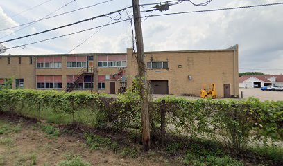
| Description | : | There were ten graves in Maple Grove Cemetery, which was adjacent to the Iowa School for the Deaf until the highway went through. At that time, the bodies were removed, and on August 19, 1954, all were placed in a single grave on the ISD campus with a memorial marker naming everyone. The original grave markers are in a room in the ISD Museum on campus. |
frequently asked questions (FAQ):
-
Where is Maple Grove Cemetery?
Maple Grove Cemetery is located at Council Bluffs, Pottawattamie County ,Iowa ,USA.
-
Maple Grove Cemetery cemetery's updated grave count on graveviews.com?
3 memorials
-
Where are the coordinates of the Maple Grove Cemetery?
Latitude: 41.2265560
Longitude: -95.8187100
Nearby Cemetories:
1. Lewis Township Cemetery
Council Bluffs, Pottawattamie County, USA
Coordinate: 41.2117004, -95.7938995
2. Clark Cemetery
Pottawattamie County, USA
Coordinate: 41.2551610, -95.8223390
3. Memorial Park Cemetery
Council Bluffs, Pottawattamie County, USA
Coordinate: 41.2644005, -95.8261032
4. Stoker-Graybill Cemetery
Council Bluffs, Pottawattamie County, USA
Coordinate: 41.2532620, -95.7751770
5. Cedar Lawn Cemetery
Council Bluffs, Pottawattamie County, USA
Coordinate: 41.2694016, -95.8182983
6. Ridgewood Cemetery
Council Bluffs, Pottawattamie County, USA
Coordinate: 41.2694016, -95.8272018
7. Oak Hill Cemetery
Council Bluffs, Pottawattamie County, USA
Coordinate: 41.2700900, -95.8226400
8. Bikhor Cholim Cemetery
Council Bluffs, Pottawattamie County, USA
Coordinate: 41.2703670, -95.8229350
9. Walnut Hill Cemetery
Council Bluffs, Pottawattamie County, USA
Coordinate: 41.2719002, -95.8255997
10. Saint Joseph Cemetery
Council Bluffs, Pottawattamie County, USA
Coordinate: 41.2722015, -95.8208008
11. Council Point Cemetery
Council Bluffs, Pottawattamie County, USA
Coordinate: 41.2110830, -95.8788610
12. Green Valley Cemetery
Council Bluffs, Pottawattamie County, USA
Coordinate: 41.2743988, -95.8225021
13. Fairview Cemetery
Council Bluffs, Pottawattamie County, USA
Coordinate: 41.2703018, -95.8480988
14. Garner Cemetery
Council Bluffs, Pottawattamie County, USA
Coordinate: 41.2956161, -95.8001709
15. Saint Pauls Evangelical Country Church Cemetery
Dumfries, Pottawattamie County, USA
Coordinate: 41.1748352, -95.7492371
16. Saint Marys Cemetery
Mills County, USA
Coordinate: 41.1517580, -95.8514000
17. Fontenelle Forest Cemetery
Bellevue, Sarpy County, USA
Coordinate: 41.1636430, -95.8887200
18. Salem Lutheran Church Cemetery
Glenwood, Mills County, USA
Coordinate: 41.1556015, -95.7617035
19. Zion Cemetery
Pottawattamie County, USA
Coordinate: 41.1778000, -95.7272000
20. Bellevue Cemetery
Bellevue, Sarpy County, USA
Coordinate: 41.1492004, -95.8944016
21. Trinity Cathedral Columbarium
Omaha, Douglas County, USA
Coordinate: 41.2603900, -95.9393660
22. Laurel Hill Cemetery
Omaha, Douglas County, USA
Coordinate: 41.1918983, -95.9417038
23. Evans Cemetery
Crescent, Pottawattamie County, USA
Coordinate: 41.3255997, -95.8368988
24. Saint Boniface Catholic Cemetery
Mills County, USA
Coordinate: 41.1419000, -95.7467100

