
| Memorials | : | 2 |
| Location | : | Lee Township, Carroll County, USA |
| Coordinate | : | 40.4935030, -80.9578650 |
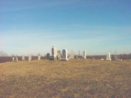
| Description | : | The cemetery is located on the north side of Steubenville Road SE (Ohio State Route 43) about 2.4 miles northwest of its intersection with North Main Street (Ohio State Route 164). The cemetery is located in the northwest corner of Section 26 and is about 3 ½ miles from Harlem Springs. The cemetery is visible from Steubenville Road SE. The cemetery is located in Lee Township, Carroll County, Ohio, and is # 1423 (Carter Cemetery / Crawford Cemetery) in “Ohio Cemeteries 1803-2003”, compiled by the Ohio Genealogical Society. The U.S. Geological Survey (USGS) Geographic Names Information System (GNIS)... Read More |
frequently asked questions (FAQ):
-
Where is Crawford Cemetery?
Crawford Cemetery is located at Steubenville Road SE Lee Township, Carroll County ,Ohio , 43903USA.
-
Crawford Cemetery cemetery's updated grave count on graveviews.com?
2 memorials
-
Where are the coordinates of the Crawford Cemetery?
Latitude: 40.4935030
Longitude: -80.9578650


Nearby Cemetories:
1. Simmons Ridge Cemetery
Carroll County, USA
Coordinate: 40.4757996, -80.9621964
2. Wells-Jackman Cemetery
Carroll County, USA
Coordinate: 40.5177994, -80.9522018
3. Amsterdam Cemetery
Loudon Township, Carroll County, USA
Coordinate: 40.4752998, -80.9250031
4. Saint Joseph Cemetery
Amsterdam, Jefferson County, USA
Coordinate: 40.4756230, -80.9229770
5. Simmons Cemetery
Carroll County, USA
Coordinate: 40.4622002, -80.9783020
6. Amsterdam Catholic Cemetery
Amsterdam, Jefferson County, USA
Coordinate: 40.4899390, -80.9093740
7. Kilgore Cemetery
Kilgore, Carroll County, USA
Coordinate: 40.4632988, -81.0014038
8. Harlem Springs Cemetery
Harlem Springs, Carroll County, USA
Coordinate: 40.5219002, -81.0053024
9. Kilgore Presbyterian Cemetery
Carroll County, USA
Coordinate: 40.4603004, -81.0002975
10. Bergholz Cemetery
Bergholz, Jefferson County, USA
Coordinate: 40.5155983, -80.8955994
11. Abel Cemetery
Carroll County, USA
Coordinate: 40.4578018, -81.0113983
12. Kisha Farm Cemetery
Wolf Run, Jefferson County, USA
Coordinate: 40.4646988, -80.8964005
13. Chestnut Ridge Cemetery
Harlem Springs, Carroll County, USA
Coordinate: 40.5491982, -80.9336014
14. McGauran Cemetery
Harlem Springs, Carroll County, USA
Coordinate: 40.5522003, -80.9749985
15. All Saints Russian Orthodox Church Cemetery
Wolf Run, Jefferson County, USA
Coordinate: 40.4598130, -80.8920900
16. Moorehead Cemetery
Carroll County, USA
Coordinate: 40.5449982, -81.0033035
17. Circle Green Cemetery
Springfield Township, Jefferson County, USA
Coordinate: 40.4817610, -80.8769050
18. Green Hill Cemetery
Carroll County, USA
Coordinate: 40.5303001, -81.0246964
19. Palmer Cemetery
Fox Township, Carroll County, USA
Coordinate: 40.5578003, -80.9764023
20. Miller Cemetery
Springfield Township, Jefferson County, USA
Coordinate: 40.4509580, -80.8913850
21. Mizer Cemetery
Amsterdam, Jefferson County, USA
Coordinate: 40.4318450, -80.9247940
22. Denver George Haddock Family Cemetery
Carrollton, Carroll County, USA
Coordinate: 40.5443880, -81.0227370
23. Lee Cemetery
Carroll County, USA
Coordinate: 40.5391998, -81.0314026
24. Downing Cemetery
Carroll County, USA
Coordinate: 40.5567017, -81.0117035