
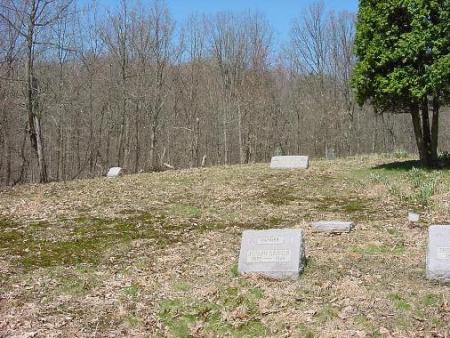
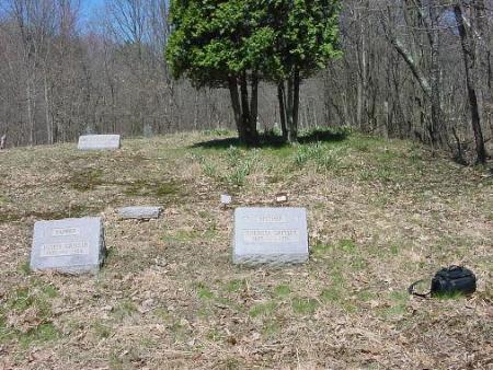
| Memorials | : | 2 |
| Location | : | Amsterdam, Jefferson County, USA |
| Coordinate | : | 40.4899390, -80.9093740 |
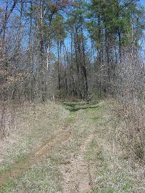
| Description | : | The cemetery is located on the northwest side of Ohio State Route 164 about 1.3 miles north of Amsterdam about 0.5 mile up a steep hill on an old farm road that intersects Ohio State Route near an oil well. The cemetery can only be reached on foot. The cemetery is located in Springfield Township, Jefferson County, Ohio, and is # 13318 (Amsterdam Catholic Cemetery) in “Ohio Cemeteries 1803-2003”, compiled by the Ohio Genealogical Society. |
frequently asked questions (FAQ):
-
Where is Amsterdam Catholic Cemetery?
Amsterdam Catholic Cemetery is located at Ohio State Route 164 Amsterdam, Jefferson County ,Ohio , 43903USA.
-
Amsterdam Catholic Cemetery cemetery's updated grave count on graveviews.com?
2 memorials
-
Where are the coordinates of the Amsterdam Catholic Cemetery?
Latitude: 40.4899390
Longitude: -80.9093740
Nearby Cemetories:
1. Saint Joseph Cemetery
Amsterdam, Jefferson County, USA
Coordinate: 40.4756230, -80.9229770
2. Amsterdam Cemetery
Loudon Township, Carroll County, USA
Coordinate: 40.4752998, -80.9250031
3. Circle Green Cemetery
Springfield Township, Jefferson County, USA
Coordinate: 40.4817610, -80.8769050
4. Kisha Farm Cemetery
Wolf Run, Jefferson County, USA
Coordinate: 40.4646988, -80.8964005
5. Bergholz Cemetery
Bergholz, Jefferson County, USA
Coordinate: 40.5155983, -80.8955994
6. All Saints Russian Orthodox Church Cemetery
Wolf Run, Jefferson County, USA
Coordinate: 40.4598130, -80.8920900
7. Crawford Cemetery
Lee Township, Carroll County, USA
Coordinate: 40.4935030, -80.9578650
8. Miller Cemetery
Springfield Township, Jefferson County, USA
Coordinate: 40.4509580, -80.8913850
9. Simmons Ridge Cemetery
Carroll County, USA
Coordinate: 40.4757996, -80.9621964
10. Wells-Jackman Cemetery
Carroll County, USA
Coordinate: 40.5177994, -80.9522018
11. Davidson Cemetery
Springfield Township, Jefferson County, USA
Coordinate: 40.4441986, -80.8818970
12. Dorn Cemetery
Bergholz, Jefferson County, USA
Coordinate: 40.5257988, -80.8625031
13. East Springfield Cemetery
East Springfield, Jefferson County, USA
Coordinate: 40.4490890, -80.8592080
14. Yellow Creek Cemetery
Bergholz, Jefferson County, USA
Coordinate: 40.5193740, -80.8438470
15. Montgomery Cemetery
East Springfield, Jefferson County, USA
Coordinate: 40.4776540, -80.8347600
16. Mizer Cemetery
Amsterdam, Jefferson County, USA
Coordinate: 40.4318450, -80.9247940
17. Simmons Cemetery
Carroll County, USA
Coordinate: 40.4622002, -80.9783020
18. Mooretown Methodist Episcopal Cemetery
Ross Township, Jefferson County, USA
Coordinate: 40.5189200, -80.8391800
19. Chestnut Ridge Cemetery
Harlem Springs, Carroll County, USA
Coordinate: 40.5491982, -80.9336014
20. Shane Cemetery
Shane, Jefferson County, USA
Coordinate: 40.4808006, -80.8127975
21. Kilgore Cemetery
Kilgore, Carroll County, USA
Coordinate: 40.4632988, -81.0014038
22. Kilgore Presbyterian Cemetery
Carroll County, USA
Coordinate: 40.4603004, -81.0002975
23. Brush Creek Baptist Cemetery
Carroll County, USA
Coordinate: 40.5624008, -80.8715973
24. Harlem Springs Cemetery
Harlem Springs, Carroll County, USA
Coordinate: 40.5219002, -81.0053024