
| Memorials | : | 0 |
| Location | : | Grants Pass, Josephine County, USA |
| Coordinate | : | 42.4483870, -123.3150180 |
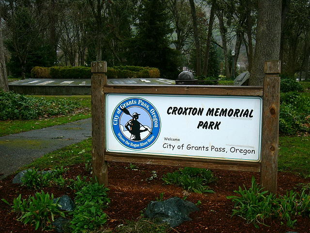
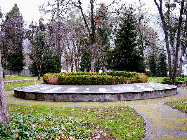
| Description | : | The park is located on Memorial Drive, off NE 9th Street at NE Cedar Lane, in Grants Pass, Oregon. Croxton Pioneer Memorial Park is no longer considered a cemetery, but a City Park. In 1856, this land was officially given by Thomas Croxton, one of many lasting ties between the Croxton family and Southern Oregon history. The cemetery was mapped by Fred Warner and Ron Cogswell in 1961, but by the early 1970s, the cemetery had been so vandalized that it was decided to gather the remaining stones and embed them in a concrete circle at the entrance to the area, and... Read More |
frequently asked questions (FAQ):
-
Where is Croxton Memorial Park?
Croxton Memorial Park is located at 1001 Memorial Drive Grants Pass, Josephine County ,Oregon ,USA.
-
Croxton Memorial Park cemetery's updated grave count on graveviews.com?
0 memorials
-
Where are the coordinates of the Croxton Memorial Park?
Latitude: 42.4483870
Longitude: -123.3150180
Nearby Cemetories:
1. Hillcrest Memorial Park Cemetery
Grants Pass, Josephine County, USA
Coordinate: 42.4569000, -123.3156200
2. St. Luke's Episcopal Church Bonney Memorial Garden
Grants Pass, Josephine County, USA
Coordinate: 42.4423026, -123.3276066
3. St. Luke's Episcopal Church Columbarium
Grants Pass, Josephine County, USA
Coordinate: 42.4421760, -123.3278260
4. Grants Pass Masonic Pioneer Cemetery
Grants Pass, Josephine County, USA
Coordinate: 42.4372830, -123.2940890
5. IOOF Cemetery
Grants Pass, Josephine County, USA
Coordinate: 42.4372670, -123.2936080
6. Hawthorne Memorial Gardens
Grants Pass, Josephine County, USA
Coordinate: 42.4444008, -123.3610992
7. Granite Hill Cemetery
Grants Pass, Josephine County, USA
Coordinate: 42.4458008, -123.3638992
8. Hall Grave
Josephine County, USA
Coordinate: 42.5253020, -123.3666690
9. Pleasant Hill Cemetery
Hugo, Josephine County, USA
Coordinate: 42.5416070, -123.3826510
10. Pleasant Valley Cemetery
Grants Pass, Josephine County, USA
Coordinate: 42.5416985, -123.3833008
11. Sloan Cemetery
Grants Pass, Josephine County, USA
Coordinate: 42.4171982, -123.4606018
12. Woodville Cemetery
Rogue River, Jackson County, USA
Coordinate: 42.4347000, -123.1583023
13. Ferrydale Cemetery
Josephine County, USA
Coordinate: 42.4625015, -123.4805984
14. Wilderville Cemetery
Wilderville, Josephine County, USA
Coordinate: 42.3792000, -123.4610977
15. Buddenhagen Family Cemetery
Grants Pass, Josephine County, USA
Coordinate: 42.3195740, -123.3530760
16. Seven Oaks Cemetery
Wimer, Jackson County, USA
Coordinate: 42.5462806, -123.1417156
17. Missouri Flat Cemetery
Applegate, Jackson County, USA
Coordinate: 42.2989998, -123.2200012
18. Rock Point Pioneer Cemetery
Gold Hill, Jackson County, USA
Coordinate: 42.4361000, -123.0852966
19. Gold Hill IOOF Cemetery
Gold Hill, Jackson County, USA
Coordinate: 42.4366989, -123.0832977
20. Hays-Gall Cemetery
Gold Hill, Jackson County, USA
Coordinate: 42.4305992, -123.0777969
21. Browning Cemetery
Josephine County, USA
Coordinate: 42.6361008, -123.3139038
22. Placer Cemetery
Placer, Josephine County, USA
Coordinate: 42.6361100, -123.3138900
23. Grave Creek Burial Site
Sunny Valley, Josephine County, USA
Coordinate: 42.6365320, -123.3773770
24. Fort Leland Burial Ground
Leland, Josephine County, USA
Coordinate: 42.6397050, -123.3902010