
| Memorials | : | 0 |
| Location | : | Ashland, Franklin County, USA |
| Coordinate | : | 34.3464340, -83.3955250 |
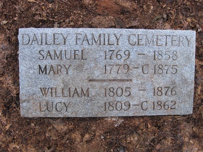
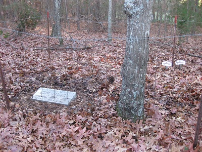
| Description | : | Near Banks-Franklin County line on Cedar Ridge Road approximately 600 feet West of Westbrook Road on the right. Park at metal farm gate. Open gate or climb over safely and follow edge of field for a few dozen yards. The cemetery is just inside the woods where the Dailey home-place probably stood. Highway 63 on the area map is known locally as "Martin Bridge Road". I maintain my great-great-great grandparent's cemetery as best as I can. I would like to express appreciation to Agatha Payne for helping us locate this sacred spot which was "lost", from family knowledge,... Read More |
frequently asked questions (FAQ):
-
Where is Dailey Family Cemetery?
Dailey Family Cemetery is located at Cedar Ridge Road Ashland, Franklin County ,Georgia , 30547USA.
-
Dailey Family Cemetery cemetery's updated grave count on graveviews.com?
0 memorials
-
Where are the coordinates of the Dailey Family Cemetery?
Latitude: 34.3464340
Longitude: -83.3955250
Nearby Cemetories:
1. Carlan Family Cemetery
Homer, Banks County, USA
Coordinate: 34.3338430, -83.4048960
2. Wilmot Cemetery
Banks County, USA
Coordinate: 34.3708000, -83.3944016
3. Westbrook Family Cemetery
Franklin County, USA
Coordinate: 34.3319020, -83.3717910
4. Nails Creek Baptist Church Cemetery
Jewelville, Banks County, USA
Coordinate: 34.3722000, -83.4052963
5. Strange Family Cemetery
Ashland, Franklin County, USA
Coordinate: 34.3710757, -83.3807366
6. Adam's Place Cemetery
Banks County, USA
Coordinate: 34.3166830, -83.3901750
7. Bellamy-Brawner-Jones Cemetery
Plainview, Franklin County, USA
Coordinate: 34.3608680, -83.3626700
8. Bush River Church Cemetery
Carlan, Banks County, USA
Coordinate: 34.3171730, -83.4108960
9. Old Salem Methodist Church Cemetery
Arp, Banks County, USA
Coordinate: 34.3157000, -83.4081000
10. Bush River Church Cemetery South
Homer, Banks County, USA
Coordinate: 34.3155190, -83.4117360
11. Arnolds Chapel C.M.E. Church Cemetery
Ashland, Franklin County, USA
Coordinate: 34.3216230, -83.3637430
12. Ebenezer Cemetery
Franklin County, USA
Coordinate: 34.3236008, -83.3572006
13. Poole Family Cemetery
Homer, Banks County, USA
Coordinate: 34.3529540, -83.4422580
14. Patterson Cemetery
Jewelville, Banks County, USA
Coordinate: 34.3852720, -83.4030600
15. Neal-Adams Family Cemetery
Ashland, Franklin County, USA
Coordinate: 34.3192700, -83.3585100
16. Mount Pleasant Methodist Church Cemetery
Banks County, USA
Coordinate: 34.3633995, -83.4429016
17. Charity Baptist Church Cemetery
Homer, Banks County, USA
Coordinate: 34.3586020, -83.4461660
18. Arendall Family Cemetery
Franklin County, USA
Coordinate: 34.3319950, -83.3433360
19. Goss Family Cemetery
Ashland, Franklin County, USA
Coordinate: 34.3064000, -83.3683800
20. Dyer-Ayers Cemetery
Homer, Banks County, USA
Coordinate: 34.3570000, -83.4508700
21. Tucker Family Cemetery
Ashland, Franklin County, USA
Coordinate: 34.3350900, -83.3402250
22. Norris Cemetery
Franklin County, USA
Coordinate: 34.3734940, -83.3487390
23. Carson Road Family Cemetery
Carnesville, Franklin County, USA
Coordinate: 34.3284210, -83.3418420
24. King Branch Baptist Church Cemetery
Franklin County, USA
Coordinate: 34.3917610, -83.3749480