
| Memorials | : | 0 |
| Location | : | Ashland, Franklin County, USA |
| Coordinate | : | 34.3192700, -83.3585100 |
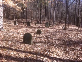
| Description | : | This cemetery is located in the deep woods of the Ashland Community in Franklin County, Georgia. The graves are on a gentle slope leading down to the northeast bank of Little Creek (Labeled on the map as "Carlan Creek" which is the headwaters of "Little Creek".) The Neal Family is an interesting branch of my Carson family tree. I have been handed down oral and written information about this family since I was a child. Several years ago we purchased adjoining land to our property and became adjoining landowners to the Neal Cemetery property. I was granted permission, by the... Read More |
frequently asked questions (FAQ):
-
Where is Neal-Adams Family Cemetery?
Neal-Adams Family Cemetery is located at Hwy. 59 Ashland, Franklin County ,Georgia , 30530USA.
-
Neal-Adams Family Cemetery cemetery's updated grave count on graveviews.com?
0 memorials
-
Where are the coordinates of the Neal-Adams Family Cemetery?
Latitude: 34.3192700
Longitude: -83.3585100
Nearby Cemetories:
1. Ebenezer Cemetery
Franklin County, USA
Coordinate: 34.3236008, -83.3572006
2. Arnolds Chapel C.M.E. Church Cemetery
Ashland, Franklin County, USA
Coordinate: 34.3216230, -83.3637430
3. Shannon Family Cemetery
Ashland, Franklin County, USA
Coordinate: 34.3134670, -83.3495670
4. Goss Family Cemetery
Ashland, Franklin County, USA
Coordinate: 34.3064000, -83.3683800
5. Carson Road Family Cemetery
Carnesville, Franklin County, USA
Coordinate: 34.3284210, -83.3418420
6. Westbrook Family Cemetery
Franklin County, USA
Coordinate: 34.3319020, -83.3717910
7. Arendall Family Cemetery
Franklin County, USA
Coordinate: 34.3319950, -83.3433360
8. Tucker Family Cemetery
Ashland, Franklin County, USA
Coordinate: 34.3350900, -83.3402250
9. Adam's Place Cemetery
Banks County, USA
Coordinate: 34.3166830, -83.3901750
10. Bold Springs Methodist Church Cemetery
Carnesville, Franklin County, USA
Coordinate: 34.2953050, -83.3346660
11. Hebron Presbyterian Cemetery
Hebron, Banks County, USA
Coordinate: 34.2855988, -83.3644028
12. Hebron Presbyterian Church Original Cemetery
Carnesville, Franklin County, USA
Coordinate: 34.2859920, -83.3465770
13. Indian Creek Baptist Church Cemetery
Franklin County, USA
Coordinate: 34.3509720, -83.3350270
14. Dailey Family Cemetery
Ashland, Franklin County, USA
Coordinate: 34.3464340, -83.3955250
15. Carlan Family Cemetery
Homer, Banks County, USA
Coordinate: 34.3338430, -83.4048960
16. Old Salem Methodist Church Cemetery
Arp, Banks County, USA
Coordinate: 34.3157000, -83.4081000
17. Bellamy-Brawner-Jones Cemetery
Plainview, Franklin County, USA
Coordinate: 34.3608680, -83.3626700
18. Bush River Church Cemetery
Carlan, Banks County, USA
Coordinate: 34.3171730, -83.4108960
19. Bush River Church Cemetery South
Homer, Banks County, USA
Coordinate: 34.3155190, -83.4117360
20. Harber Family Cemetery
Carnesville, Franklin County, USA
Coordinate: 34.3334760, -83.3065940
21. Neals Grove Baptist Church Cemetery
Hebron, Banks County, USA
Coordinate: 34.2754820, -83.3945780
22. Holbrook Cemetery
Cromers, Franklin County, USA
Coordinate: 34.3216667, -83.2925000
23. Norris Cemetery
Franklin County, USA
Coordinate: 34.3734940, -83.3487390
24. Strange Family Cemetery
Ashland, Franklin County, USA
Coordinate: 34.3710757, -83.3807366