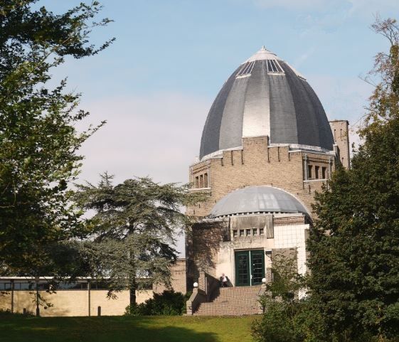
| Memorials | : | 0 |
| Location | : | Driehuis, Velsen Municipality, Netherlands |
| Phone | : | 0255-51-48-43 |
| Coordinate | : | 52.4478360, 4.6308560 |
| Description | : | The dome-top crematorium was built between 1912 and 1913 by architects M. A. Poel and P. L. Kramer. The building has expanded several times over the years. The building contains an auditorium and urn galleries in addition to a garden urn field outside. There are nearly 600 buried urns on the site. The building is a National Dutch Monument. During World War II, German troops occupied the building as the top of the dome acted as a lookout post providing a view for miles. |
frequently asked questions (FAQ):
-
Where is Driehuis Velsen Crematorium?
Driehuis Velsen Crematorium is located at Duin and Kruidbergerweg 2-6 Driehuis, Velsen Municipality ,Noord-Holland , 1985Netherlands.
-
Driehuis Velsen Crematorium cemetery's updated grave count on graveviews.com?
0 memorials
-
Where are the coordinates of the Driehuis Velsen Crematorium?
Latitude: 52.4478360
Longitude: 4.6308560
Nearby Cemetories:
1. Begraafplaats & Crematorium Westerveld
Driehuis, Velsen Municipality, Netherlands
Coordinate: 52.4447200, 4.6315700
2. Begraafplaats Duinhof
IJmuiden, Velsen Municipality, Netherlands
Coordinate: 52.4464790, 4.6244280
3. Ijmuiden Western Cemetery
IJmuiden, Velsen Municipality, Netherlands
Coordinate: 52.4593400, 4.6000500
4. Akendam Cemetery
Haarlem, Haarlem Municipality, Netherlands
Coordinate: 52.4233700, 4.6574200
5. RC Cemetery Sint Jozef
Haarlem, Haarlem Municipality, Netherlands
Coordinate: 52.4232440, 4.6612690
6. Joodse Begraafplaats Provinciaal Ziekenhuis Santpoort
Bloemendaal, Bloemendaal Municipality, Netherlands
Coordinate: 52.4181100, 4.6160400
7. Bloemendaal General Cemetery
Bloemendaal, Bloemendaal Municipality, Netherlands
Coordinate: 52.4165100, 4.6121900
8. Bloemendaal Sint Adelbertus Catholic Churchyard
Bloemendaal, Bloemendaal Municipality, Netherlands
Coordinate: 52.4112900, 4.6229100
9. Beverwijk General Cemetery
Beverwijk, Beverwijk Municipality, Netherlands
Coordinate: 52.4932300, 4.6370000
10. Haarlem Sint-Barbarabegraafplaats
Haarlem, Haarlem Municipality, Netherlands
Coordinate: 52.3988200, 4.6437400
11. Wijk aan zee Protestant Cemetery
Wijk aan Zee, Beverwijk Municipality, Netherlands
Coordinate: 52.4920400, 4.5913800
12. Joodse begraafplaats Kleverlaan
Haarlem, Haarlem Municipality, Netherlands
Coordinate: 52.3957320, 4.6397830
13. Algemene Begraafplaats Kleverlaan
Haarlem Municipality, Netherlands
Coordinate: 52.3950000, 4.6389500
14. Haarlem General Cemetery
Haarlem, Haarlem Municipality, Netherlands
Coordinate: 52.3948100, 4.6388300
15. Bloemendaal Erebegraafplaats
Overveen, Bloemendaal Municipality, Netherlands
Coordinate: 52.4010500, 4.5759500
16. Spaarnwoude Cemetery
Spaarnwoude, Haarlemmerliede en Spaarnwoude Municipality, Netherlands
Coordinate: 52.4045521, 4.6939543
17. Joodse Begraafplaats Duinland
Overveen, Bloemendaal Municipality, Netherlands
Coordinate: 52.3913000, 4.5989100
18. Sint-Bavokerk
Haarlem, Haarlem Municipality, Netherlands
Coordinate: 52.3810680, 4.6372160
19. Heemskerk Protestant Churchyard
Heemskerk, Heemskerk Municipality, Netherlands
Coordinate: 52.5103100, 4.6711700
20. Joodse begraafplaats Amsterdamsevaart
Haarlem, Haarlem Municipality, Netherlands
Coordinate: 52.3818800, 4.6663620
21. Zandvoort Algemene Begraafplaats
Zandvoort, Zandvoort Municipality, Netherlands
Coordinate: 52.3758300, 4.5428200
22. Begraafplaats Westzaan
Westzaan, Zaanstad Municipality, Netherlands
Coordinate: 52.4549454, 4.7836463
23. Rooms Katholieke begraafplaats
Uitgeest, Uitgeest Municipality, Netherlands
Coordinate: 52.5266880, 4.7151508
24. R.K.Kerkhof St. Bavo Berkenrode
Heemstede Municipality, Netherlands
Coordinate: 52.3522584, 4.6141497

