
| Memorials | : | 0 |
| Location | : | Bloemendaal, Bloemendaal Municipality, Netherlands |
| Coordinate | : | 52.4181100, 4.6160400 |
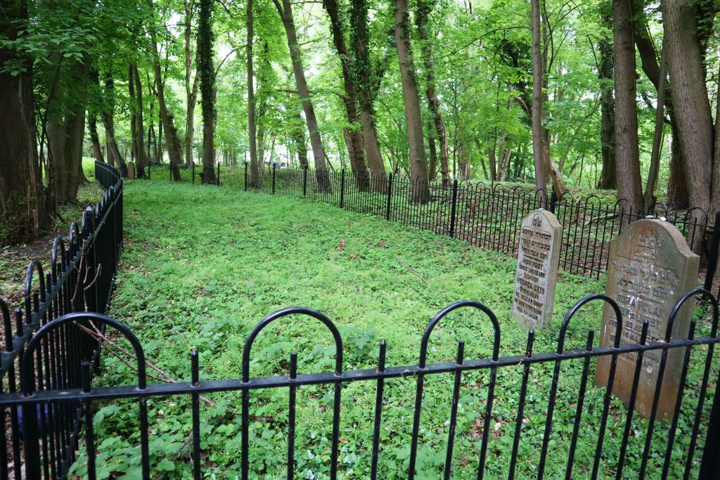
| Description | : | In 1849 the psychiatric hospital âPbMeer en BergâPc opened. According to the documents in the North Holland Archives, there were three cemeteries (Catholic, Jewish, General) on the site by the end of the 19th century. In 1918 the name of the hospital was changed to âPbProvinciaal Ziekenhuis SantpoortâPc. The Jewish cemetery was in use from circa 1903 until 1937. Only three matsevahs remain standing; the size of the field indicate there are graves that are not marked. |
frequently asked questions (FAQ):
-
Where is Joodse Begraafplaats Provinciaal Ziekenhuis Santpoort?
Joodse Begraafplaats Provinciaal Ziekenhuis Santpoort is located at Brederodelaan Bloemendaal, Bloemendaal Municipality ,Noord-Holland ,Netherlands.
-
Joodse Begraafplaats Provinciaal Ziekenhuis Santpoort cemetery's updated grave count on graveviews.com?
0 memorials
-
Where are the coordinates of the Joodse Begraafplaats Provinciaal Ziekenhuis Santpoort?
Latitude: 52.4181100
Longitude: 4.6160400
Nearby Cemetories:
1. Bloemendaal General Cemetery
Bloemendaal, Bloemendaal Municipality, Netherlands
Coordinate: 52.4165100, 4.6121900
2. Bloemendaal Sint Adelbertus Catholic Churchyard
Bloemendaal, Bloemendaal Municipality, Netherlands
Coordinate: 52.4112900, 4.6229100
3. Haarlem Sint-Barbarabegraafplaats
Haarlem, Haarlem Municipality, Netherlands
Coordinate: 52.3988200, 4.6437400
4. Akendam Cemetery
Haarlem, Haarlem Municipality, Netherlands
Coordinate: 52.4233700, 4.6574200
5. Joodse begraafplaats Kleverlaan
Haarlem, Haarlem Municipality, Netherlands
Coordinate: 52.3957320, 4.6397830
6. Algemene Begraafplaats Kleverlaan
Haarlem Municipality, Netherlands
Coordinate: 52.3950000, 4.6389500
7. Haarlem General Cemetery
Haarlem, Haarlem Municipality, Netherlands
Coordinate: 52.3948100, 4.6388300
8. RC Cemetery Sint Jozef
Haarlem, Haarlem Municipality, Netherlands
Coordinate: 52.4232440, 4.6612690
9. Begraafplaats & Crematorium Westerveld
Driehuis, Velsen Municipality, Netherlands
Coordinate: 52.4447200, 4.6315700
10. Joodse Begraafplaats Duinland
Overveen, Bloemendaal Municipality, Netherlands
Coordinate: 52.3913000, 4.5989100
11. Begraafplaats Duinhof
IJmuiden, Velsen Municipality, Netherlands
Coordinate: 52.4464790, 4.6244280
12. Bloemendaal Erebegraafplaats
Overveen, Bloemendaal Municipality, Netherlands
Coordinate: 52.4010500, 4.5759500
13. Driehuis Velsen Crematorium
Driehuis, Velsen Municipality, Netherlands
Coordinate: 52.4478360, 4.6308560
14. Sint-Bavokerk
Haarlem, Haarlem Municipality, Netherlands
Coordinate: 52.3810680, 4.6372160
15. Ijmuiden Western Cemetery
IJmuiden, Velsen Municipality, Netherlands
Coordinate: 52.4593400, 4.6000500
16. Joodse begraafplaats Amsterdamsevaart
Haarlem, Haarlem Municipality, Netherlands
Coordinate: 52.3818800, 4.6663620
17. Spaarnwoude Cemetery
Spaarnwoude, Haarlemmerliede en Spaarnwoude Municipality, Netherlands
Coordinate: 52.4045521, 4.6939543
18. Zandvoort Algemene Begraafplaats
Zandvoort, Zandvoort Municipality, Netherlands
Coordinate: 52.3758300, 4.5428200
19. R.K.Kerkhof St. Bavo Berkenrode
Heemstede Municipality, Netherlands
Coordinate: 52.3522584, 4.6141497
20. Wijk aan zee Protestant Cemetery
Wijk aan Zee, Beverwijk Municipality, Netherlands
Coordinate: 52.4920400, 4.5913800
21. Vijfhuizen Jewish monument
Vijfhuizen, Haarlemmermeer Municipality, Netherlands
Coordinate: 52.3526102, 4.6795842
22. Beverwijk General Cemetery
Beverwijk, Beverwijk Municipality, Netherlands
Coordinate: 52.4932300, 4.6370000
23. Heemstede Algemene Begraafplaats
Heemstede, Heemstede Municipality, Netherlands
Coordinate: 52.3406700, 4.6197700
24. Zwanenburg Algemene Begraafplaats
Zwanenburg, Haarlemmermeer Municipality, Netherlands
Coordinate: 52.3769900, 4.7449800