
| Memorials | : | 4 |
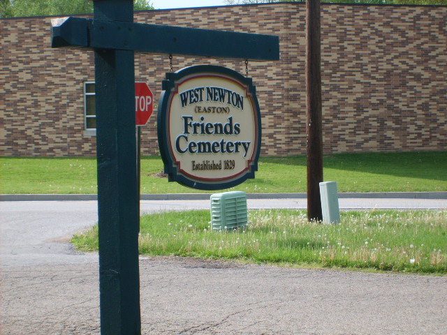
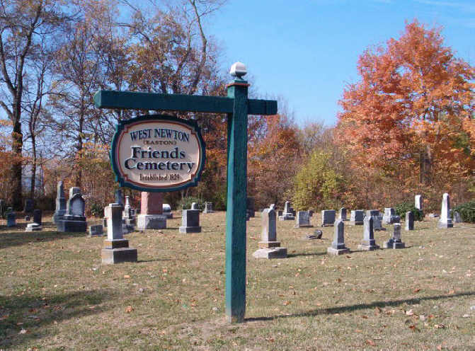
| Location | : | West Newton, Marion County, USA |
| Coordinate | : | 39.6539450, -86.2797060 |
| Description | : | Easton Friends Cemetery (A.K.A. West Newton) is a large cemetery of over 400 stones. Some of the older stones are difficult to read. Established in: 1829 DIRECTIONS: Exit-465 at Kentucky Ave. on the southwest side of Marion County. Turn left onto Kentucky Ave. and go southeast .3 miles to High School Road, (turn left at the McDonald's)and go south 2.8 miles (after 1 mile, High School Rd. becomes Mooresville Rd) to Quaker Road. The cemetery is on the right side of Mooresville Road at the intersection, across from the West Newton Elementary School. Parking is on the side... Read More |
frequently asked questions (FAQ):
-
Where is Easton Friends Cemetery?
Easton Friends Cemetery is located at 7500 Mooresville Rd West Newton, Marion County ,Indiana ,USA.
-
Easton Friends Cemetery cemetery's updated grave count on graveviews.com?
4 memorials
-
Where are the coordinates of the Easton Friends Cemetery?
Latitude: 39.6539450
Longitude: -86.2797060

Nearby Cemetories:
1. West Newton Cemetery
West Newton, Marion County, USA
Coordinate: 39.6502037, -86.2781982
2. Mount Pleasant Baptist Cemetery
West Newton, Marion County, USA
Coordinate: 39.6702160, -86.2503010
3. McNabb Cemetery
Morgan County, USA
Coordinate: 39.6219720, -86.2825830
4. Landers Family Cemetery
Landersdale, Morgan County, USA
Coordinate: 39.6260986, -86.2544022
5. Siloam Cemetery
Morgan County, USA
Coordinate: 39.6286011, -86.3236008
6. Old Friends Cemetery (Defunct)
Marion County, USA
Coordinate: 39.6966270, -86.2885390
7. Lick Branch Cemetery
Plainfield, Hendricks County, USA
Coordinate: 39.6598663, -86.3356476
8. Lick Branch Cemetery
Guilford Township, Hendricks County, USA
Coordinate: 39.6598800, -86.3357040
9. Fairfield Friends Cemetery
Friendswood, Hendricks County, USA
Coordinate: 39.6606026, -86.3355865
10. Mount Olive Cemetery
Landersdale, Morgan County, USA
Coordinate: 39.6108017, -86.2716980
11. Beeler Cemetery
Marion County, USA
Coordinate: 39.6898880, -86.2434692
12. Lick Branch Cemetery (Defunct)
Decatur Township, Marion County, USA
Coordinate: 39.7067000, -86.3025000
13. Center Friends Cemetery
Bridgeport, Marion County, USA
Coordinate: 39.6975784, -86.3258438
14. Fowler-Mundy Cemetery
Marion County, USA
Coordinate: 39.6603900, -86.2058700
15. Bethel Cemetery (Defunct)
Indianapolis, Marion County, USA
Coordinate: 39.7131882, -86.2751846
16. Carter Evans Cemetery
Morgan County, USA
Coordinate: 39.5956670, -86.3073330
17. Indianapolis International Airport
Indianapolis, Marion County, USA
Coordinate: 39.7170600, -86.2949700
18. Mount Pleasant Cemetery
Greenwood, Johnson County, USA
Coordinate: 39.6282997, -86.1967010
19. Mars Hill Cemetery
Marion County, USA
Coordinate: 39.7128750, -86.2300480
20. Rhoads Cemetery (Defunct)
Indianapolis, Marion County, USA
Coordinate: 39.7250250, -86.2609660
21. Bell Cemetery
Indianapolis, Marion County, USA
Coordinate: 39.6857986, -86.1924973
22. Carpenter Cemetery
Mooresville, Morgan County, USA
Coordinate: 39.5949040, -86.3395920
23. Robinson Cemetery #1
White River Township, Johnson County, USA
Coordinate: 39.6022650, -86.2055130
24. Alcorn-Titler Cemetery
Marion County, USA
Coordinate: 39.6711922, -86.1791382