
| Memorials | : | 7 |
| Location | : | McArthur, Vinton County, USA |
| Coordinate | : | 39.3811792, -82.5051573 |
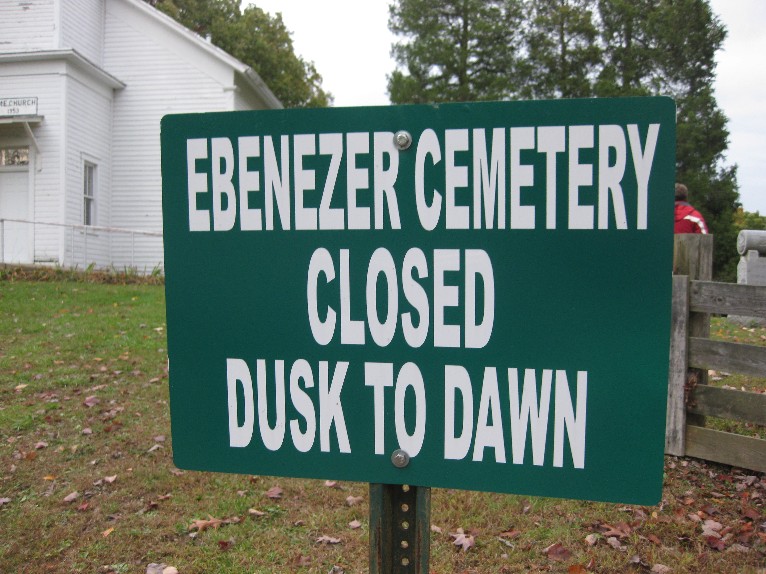
| Description | : | The cemetery is located on the northeast side of Creola-Hue Road (County Road 33) at its intersection with Boring Road (County Road 5) about 2300 feet south of its intersection with Ohio State Route 56. The cemetery is located in Swan Township, Vinton County, Ohio, and is # 12165 (Ebenezer Cemetery) in “Ohio Cemeteries 1803-2003”, compiled by the Ohio Genealogical Society. The cemetery is registered with the Ohio Division of Real Estate and Professional Licensing (ODRE) as Ebenezer Cemetery with registration license number CGR.0000981515. The U.S. Geological Survey (USGS) Geographic Names Information System (GNIS) feature ID for the... Read More |
frequently asked questions (FAQ):
-
Where is Ebenezer Cemetery?
Ebenezer Cemetery is located at Creola-Hue Road (County Road 33) and Boring Road (County Road 5) McArthur, Vinton County ,Ohio , 45622USA.
-
Ebenezer Cemetery cemetery's updated grave count on graveviews.com?
7 memorials
-
Where are the coordinates of the Ebenezer Cemetery?
Latitude: 39.3811792
Longitude: -82.5051573
Nearby Cemetories:
1. Fairview Church Cemetery
Washington Township, Hocking County, USA
Coordinate: 39.4011192, -82.4872818
2. Mount Pleasant Methodist Church Cemetery
Mount Pleasant, Vinton County, USA
Coordinate: 39.3928200, -82.4600370
3. Johnson Cemetery
Mount Pleasant, Vinton County, USA
Coordinate: 39.3809400, -82.4561000
4. Wesley Chapel Cemetery
South Bloomingville, Hocking County, USA
Coordinate: 39.4110400, -82.5388300
5. Prose Cemetery
Vinton County, USA
Coordinate: 39.3616982, -82.4571991
6. Mitchell Family Cemetery
Vinton County, USA
Coordinate: 39.3427810, -82.4668280
7. Locust Grove Cemetery
Vinton County, USA
Coordinate: 39.3489070, -82.5520210
8. Bethel Cemetery
Creola, Vinton County, USA
Coordinate: 39.3423610, -82.4667500
9. Saint John the Baptist Cemetery
Benton Township, Hocking County, USA
Coordinate: 39.4294014, -82.5294037
10. Susannah Byerly Grave
Creola, Vinton County, USA
Coordinate: 39.3330000, -82.4710000
11. Mount Zion Cemetery
Vinton County, USA
Coordinate: 39.3231010, -82.4927979
12. Liberty Hill Cemetery
South Bloomingville, Hocking County, USA
Coordinate: 39.3953620, -82.5815690
13. Otterbein Chapel Cemetery
Allensville, Vinton County, USA
Coordinate: 39.3587320, -82.5804440
14. Spunk Cemetery
Vinton County, USA
Coordinate: 39.3624992, -82.5856018
15. Ilesboro Cemetery
Washington Township, Hocking County, USA
Coordinate: 39.4322900, -82.4510000
16. Conley Family Cemetery
Creola, Vinton County, USA
Coordinate: 39.3185390, -82.4709010
17. Creola Cemetery
Creola, Vinton County, USA
Coordinate: 39.3182983, -82.4702988
18. Wesley Chapel Cemetery
Vinton County, USA
Coordinate: 39.3456001, -82.4274979
19. Olive Branch Cemetery
Washington Township, Hocking County, USA
Coordinate: 39.4105988, -82.4175034
20. Centenary Cemetery
Vinton County, USA
Coordinate: 39.3135986, -82.5522003
21. Chestnut Grove Cemetery
Vinton County, USA
Coordinate: 39.3703194, -82.6054535
22. New Plymouth Cemetery
New Plymouth, Vinton County, USA
Coordinate: 39.3899100, -82.4029800
23. South Bloomingville Cemetery
South Bloomingville, Hocking County, USA
Coordinate: 39.4160000, -82.5991600
24. Stevens-Robb Cemetery
Zaleski, Vinton County, USA
Coordinate: 39.3002700, -82.5050580