
| Memorials | : | 1 |
| Location | : | New Zealand |
| Coordinate | : | -50.5441067, 166.2095198 |
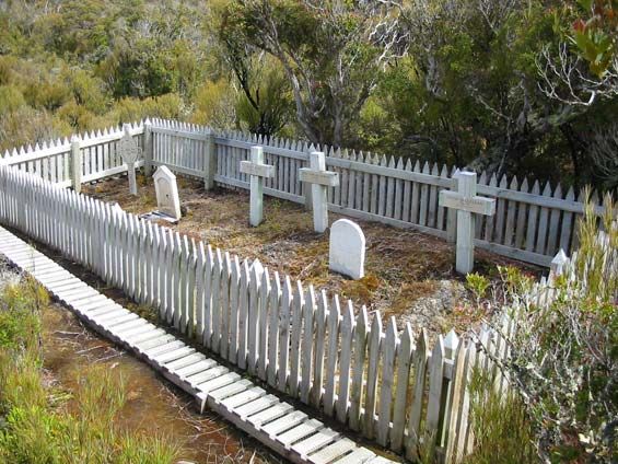
| Description | : | All that remains of the ill-fated Enderby Settlement, New Zealand’s southern-most planned settlement, is a few indistinct building platforms, a faint road alignment, and a small cemetery. In 1849 Charles Enderby, director of a prominent whaling company, obtained the support of the British Government to establish a land based whaling station and colony at Port Ross. The island was not part of either New Zealand or Australia at the time, so it was an independent colony. Three Enderby Company ships loaded with stores and settlers landed at the Auckland Islands in December 1849, where they discovered around 70 Māori and Moriori... Read More |
frequently asked questions (FAQ):
-
Where is Enderby Cemetery?
Enderby Cemetery is located at Hardwicke, Port Ross, Auckland Island, New Zealand Subantarctic Islands, Area Outside Territorial Authority New Zealand.
-
Enderby Cemetery cemetery's updated grave count on graveviews.com?
1 memorials
-
Where are the coordinates of the Enderby Cemetery?
Latitude: -50.5441067
Longitude: 166.2095198
Nearby Cemetories:
1. Perseverance Harbour Burial Site
New Zealand
Coordinate: -52.5548042, 169.1342928
2. Campbell Island Graves
New Zealand
Coordinate: -52.5343942, 169.1728671
3. South Cape, Rakiura National Park Lone Graves
Stewart Island, Southland District, New Zealand
Coordinate: -47.2667316, 167.5999384
4. The Neck
Stewart Island, Southland District, New Zealand
Coordinate: -46.9249600, 168.1922400
5. Halfmoon Bay Cemetery
Stewart Island, Southland District, New Zealand
Coordinate: -46.8947480, 168.1248950
6. Braggs Bay Cemetery
Stewart Island, Southland District, New Zealand
Coordinate: -46.8896680, 168.1397690
7. Horseshoe Bay Cemetery
Stewart Island, Southland District, New Zealand
Coordinate: -46.8814467, 168.1334396
8. Ruapuke Island Cemetery
Southland District, New Zealand
Coordinate: -46.7881040, 168.5048690
9. Bluff Cemetery
Bluff, Invercargill City, New Zealand
Coordinate: -46.6017310, 168.3248670
10. Captain Stirling Grave
Bluff, Invercargill City, New Zealand
Coordinate: -46.6016466, 168.3691108
11. Green Point Cemetery
Bluff, Invercargill City, New Zealand
Coordinate: -46.5739350, 168.3006450
12. Tararua Acre
Otara, Southland District, New Zealand
Coordinate: -46.6551940, 168.8762500
13. Wakapatu Cemetery
Wakapatu, Southland District, New Zealand
Coordinate: -46.3806050, 167.8060970
14. Colac Bay Cemetery
Colac Bay, Southland District, New Zealand
Coordinate: -46.3679806, 167.8798528
15. Fortrose Cemetery
Fortrose, Southland District, New Zealand
Coordinate: -46.5694400, 168.8088500
16. Orepuki Cemetery
Orepuki, Southland District, New Zealand
Coordinate: -46.3028250, 167.7240360
17. Te Hau Mutunga Urupā
Invercargill, Invercargill City, New Zealand
Coordinate: -46.4288704, 168.4148361
18. Southland Crematorium
Invercargill, Invercargill City, New Zealand
Coordinate: -46.4109100, 168.3961330
19. Riverton Cemetery
Riverton, Southland District, New Zealand
Coordinate: -46.3316900, 168.0215500
20. Waikawa Cemetery
Waikawa, Southland District, New Zealand
Coordinate: -46.6093780, 169.1289750
21. Eastern Cemetery
Invercargill, Invercargill City, New Zealand
Coordinate: -46.4070770, 168.3961480
22. Holy Trinity Anglican Church
Invercargill, Invercargill City, New Zealand
Coordinate: -46.3984736, 168.3660057
23. All Saints Anglican Church
Invercargill, Invercargill City, New Zealand
Coordinate: -46.3906042, 168.3476728
24. Saint Johns Cemetery
Invercargill, Invercargill City, New Zealand
Coordinate: -46.3748600, 168.3431480