
| Memorials | : | 0 |
| Location | : | Powiat goleniowski, Poland |
| Coordinate | : | 53.6602298, 14.9775693 |
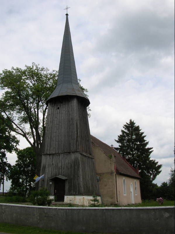
| Description | : | In Polish the name would be Cmentarz Ewangelicki-Lutheryjski w Węgorza. The church cemetery is in the plot for the present branch church of St. John the Baptist - entered in the register of monuments, Reg. No. 453. The hall church, made of stone, was built at the turn of the 15th / 16th century and has a half-timbered belfry from the 18th century. The church is located in the northern part of the village. It has a granite baptismal font in the west and a church wall. An irregular plot delimited by a brick fence forms the... Read More |
frequently asked questions (FAQ):
-
Where is Evangelisch-Lutheranischer Friedhof von Fanger?
Evangelisch-Lutheranischer Friedhof von Fanger is located at Powiat goleniowski ,Zachodniopomorskie ,Poland.
-
Evangelisch-Lutheranischer Friedhof von Fanger cemetery's updated grave count on graveviews.com?
0 memorials
-
Where are the coordinates of the Evangelisch-Lutheranischer Friedhof von Fanger?
Latitude: 53.6602298
Longitude: 14.9775693
Nearby Cemetories:
1. Cmentarz Komunalny w Strzelewie
Powiat goleniowski, Poland
Coordinate: 53.6756662, 14.9990416
2. Ev.-lutherischer Kirchfriedhof Basenthin (Bodzęcin
Powiat goleniowski, Poland
Coordinate: 53.6348427, 14.9268505
3. Ev.-lutherischer Kirchfriedhof Kriewitz (Krzywice)
Powiat goleniowski, Poland
Coordinate: 53.6012116, 14.9643436
4. Ev.-lutherischer Friedhof von Glewitz (Glewice)
Powiat goleniowski, Poland
Coordinate: 53.6069373, 14.9132945
5. Evangelisch-Lutheranischer Friedhof von Trechel
Powiat goleniowski, Poland
Coordinate: 53.7346668, 14.9650317
6. Ev.-lutherischer Friedhof Dischenhagen (Dzisna)
Powiat goleniowski, Poland
Coordinate: 53.6846897, 14.8439832
7. Cmentarz Komunalny w Nowogard
Szczecin, Miasto Szczecin, Poland
Coordinate: 53.6628579, 15.1180895
8. Cmentarz Komunalny w Blotno
Powiat goleniowski, Poland
Coordinate: 53.7559511, 15.0178137
9. Evangelisch-Lutheranischer Friedhof von Gollnow
Szczecin, Miasto Szczecin, Poland
Coordinate: 53.5573402, 14.8215340
10. Evangelisch-Lutheranischer Friedhof von Plantikow
Szczecin, Miasto Szczecin, Poland
Coordinate: 53.6006035, 15.2411593
11. Ev.-lutherischer Friedhof Ludwigshorst (Taczały)
Powiat łobeski, Poland
Coordinate: 53.7439460, 15.2721200
12. Friedhof Gross Benz
Powiat łobeski, Poland
Coordinate: 53.6141030, 15.2989770
13. Cmentarz Dobra
Szczecin, Miasto Szczecin, Poland
Coordinate: 53.5859698, 15.3021461
14. Cmentarz w Borzysławcu
Powiat goleniowski, Poland
Coordinate: 53.5190030, 14.7191929
15. Evangelisch-Lutheranischer Friedhof von Karlsbach
Powiat stargardzki, Poland
Coordinate: 53.4465560, 14.8874502
16. Lubczyna Lapidarium
Powiat goleniowski, Poland
Coordinate: 53.5073500, 14.7100500
17. Cmentarz w Chlebówku
Powiat stargardzki, Poland
Coordinate: 53.4684140, 15.1759636
18. Cmentarz w Kania
Powiat stargardzki, Poland
Coordinate: 53.4989516, 15.2433455
19. Evangelisch-Lutheranischer Friedhof von Roggow A
Powiat łobeski, Poland
Coordinate: 53.6355946, 15.3581663
20. Cmentarz w Poczernin
Powiat stargardzki, Poland
Coordinate: 53.4244760, 14.9547506
21. Cmentarz w Małkocin
Powiat stargardzki, Poland
Coordinate: 53.4042790, 15.0290288
22. Evangelisch-Lutheranischer Friedhof von Roggow
Powiat stargardzki, Poland
Coordinate: 53.4015718, 14.9828398
23. Evangelisch-Lutheranischer Friedhof von Karkow
Powiat stargardzki, Poland
Coordinate: 53.4753318, 15.2854060
24. Evangelisch-Lutheranischer Friedhof von Bandekow
Powiat gryficki, Poland
Coordinate: 53.8512718, 15.2937566