
| Memorials | : | 0 |
| Location | : | New York, New York County (Manhattan), USA |
| Coordinate | : | 40.7042940, -74.0137730 |
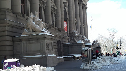
| Description | : | The first Fort George was built in 1626 in the Dutch colony of New Amsterdam and named Fort Amsterdam. Eventually, after a series of name changes, the British named it Fort George in 1714. Parts of the fort were destroyed in the American Revolutionary War in 1776 by the Americans. It was finally demolished in 1790. The site is now the location of the Alexander Hamilton U.S. Custom House in Lower Manhattan. |
frequently asked questions (FAQ):
-
Where is Fort George Chapel?
Fort George Chapel is located at Whitehall Street New York, New York County (Manhattan) ,New York , 10004USA.
-
Fort George Chapel cemetery's updated grave count on graveviews.com?
0 memorials
-
Where are the coordinates of the Fort George Chapel?
Latitude: 40.7042940
Longitude: -74.0137730
Nearby Cemetories:
1. Dutch Reformed Church Cemetery
Manhattan, New York County (Manhattan), USA
Coordinate: 40.7060300, -74.0133600
2. East Coast Memorial
Manhattan, New York County (Manhattan), USA
Coordinate: 40.7020378, -74.0160599
3. South Dutch Churchyard
Manhattan, New York County (Manhattan), USA
Coordinate: 40.7060930, -74.0105060
4. Trinity Lutheran Churchyard
Manhattan, New York County (Manhattan), USA
Coordinate: 40.7073870, -74.0122470
5. Cholera Hospital Burial Ground
Manhattan, New York County (Manhattan), USA
Coordinate: 40.7060510, -74.0093190
6. First Presbyterian Church Wall Street
Manhattan, New York County (Manhattan), USA
Coordinate: 40.7076070, -74.0110900
7. Trinity Churchyard
Manhattan, New York County (Manhattan), USA
Coordinate: 40.7085000, -74.0122100
8. Public Burial Ground of New Amsterdam and New York
Manhattan, New York County (Manhattan), USA
Coordinate: 40.7085490, -74.0118080
9. French Church of Saint Esprit Cemetery
Manhattan, New York County (Manhattan), USA
Coordinate: 40.7076760, -74.0096140
10. Associate Presbyterian Churchyard
New York County (Manhattan), USA
Coordinate: 40.7083560, -74.0103860
11. Middle Dutch Church
New York, New York County (Manhattan), USA
Coordinate: 40.7082530, -74.0094650
12. Little Green Street Burial Ground of the Society o
Manhattan, New York County (Manhattan), USA
Coordinate: 40.7092150, -74.0097550
13. National September 11 Memorial
Manhattan, New York County (Manhattan), USA
Coordinate: 40.7115200, -74.0133000
14. First Moravian Churchyard
Manhattan, New York County (Manhattan), USA
Coordinate: 40.7097010, -74.0070060
15. North Dutch Churchyard
Manhattan, New York County (Manhattan), USA
Coordinate: 40.7098300, -74.0064020
16. Saint Paul's Chapel and Churchyard
Manhattan, New York County (Manhattan), USA
Coordinate: 40.7117800, -74.0096800
17. Saint Peter's Catholic Church Cemetery
Manhattan, New York County (Manhattan), USA
Coordinate: 40.7121350, -74.0097410
18. Old Brick Presbyterian Church Cemetery
Manhattan, New York County (Manhattan), USA
Coordinate: 40.7116340, -74.0064030
19. Second African Burial Ground
Manhattan, New York County (Manhattan), USA
Coordinate: 40.7144400, -74.0047200
20. African Burial Ground National Monument
New York, New York County (Manhattan), USA
Coordinate: 40.7144400, -74.0047200
21. Duane Street Methodist Church Cemetery
New York, New York County (Manhattan), USA
Coordinate: 40.7171050, -74.0092460
22. First Cemetery of Congregation Shearith Israel
Chinatown, New York County (Manhattan), USA
Coordinate: 40.7129211, -73.9985352
23. Oliver Street Baptist Churchyard
Manhattan, New York County (Manhattan), USA
Coordinate: 40.7128470, -73.9977730
24. Horsfield Graveyard
Brooklyn Heights, Kings County (Brooklyn), USA
Coordinate: 40.7013850, -73.9942910