
| Memorials | : | 0 |
| Location | : | Manhattan, New York County (Manhattan), USA |
| Coordinate | : | 40.7098300, -74.0064020 |
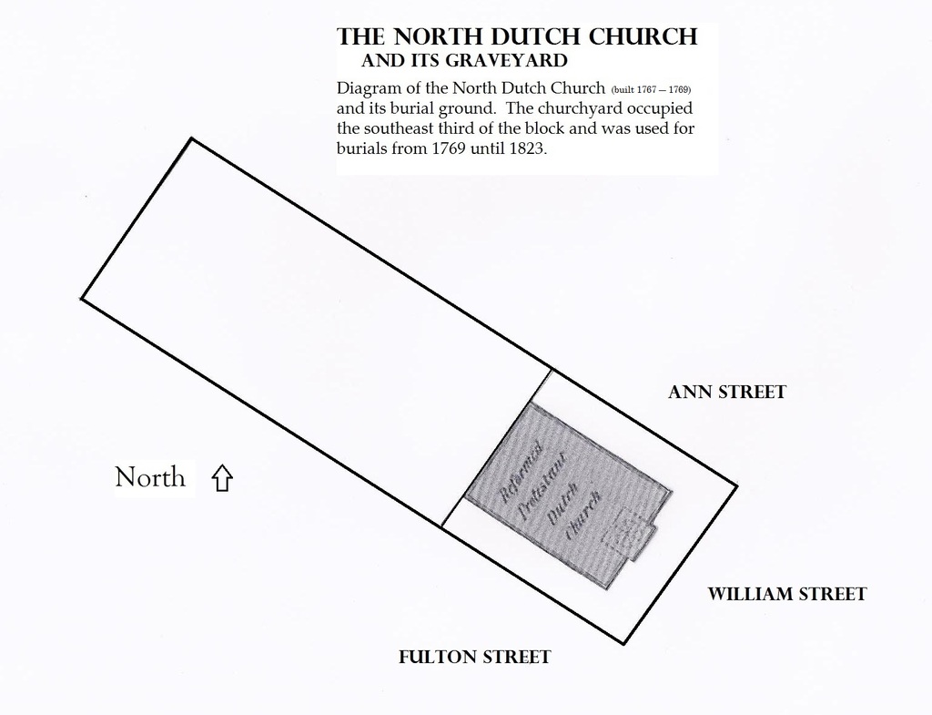
| Description | : | North Dutch Church was located on William Street, between Fulton Street and Ann Street in Manhattan. The Reformed Dutch church was built in 1769. The North Dutch Church was demolished in the 1860s. The remains in the cemetery were supposedly moved to an unspecified location. The cemetery was officially used from 1768 to 1823. |
frequently asked questions (FAQ):
-
Where is North Dutch Churchyard?
North Dutch Churchyard is located at William Street, between Fulton and Ann Streets Manhattan, New York County (Manhattan) ,New York ,USA.
-
North Dutch Churchyard cemetery's updated grave count on graveviews.com?
0 memorials
-
Where are the coordinates of the North Dutch Churchyard?
Latitude: 40.7098300
Longitude: -74.0064020
Nearby Cemetories:
1. First Moravian Churchyard
Manhattan, New York County (Manhattan), USA
Coordinate: 40.7097010, -74.0070060
2. Old Brick Presbyterian Church Cemetery
Manhattan, New York County (Manhattan), USA
Coordinate: 40.7116340, -74.0064030
3. Little Green Street Burial Ground of the Society o
Manhattan, New York County (Manhattan), USA
Coordinate: 40.7092150, -74.0097550
4. Middle Dutch Church
New York, New York County (Manhattan), USA
Coordinate: 40.7082530, -74.0094650
5. Saint Paul's Chapel and Churchyard
Manhattan, New York County (Manhattan), USA
Coordinate: 40.7117800, -74.0096800
6. French Church of Saint Esprit Cemetery
Manhattan, New York County (Manhattan), USA
Coordinate: 40.7076760, -74.0096140
7. Associate Presbyterian Churchyard
New York County (Manhattan), USA
Coordinate: 40.7083560, -74.0103860
8. Saint Peter's Catholic Church Cemetery
Manhattan, New York County (Manhattan), USA
Coordinate: 40.7121350, -74.0097410
9. First Presbyterian Church Wall Street
Manhattan, New York County (Manhattan), USA
Coordinate: 40.7076070, -74.0110900
10. Public Burial Ground of New Amsterdam and New York
Manhattan, New York County (Manhattan), USA
Coordinate: 40.7085490, -74.0118080
11. Cholera Hospital Burial Ground
Manhattan, New York County (Manhattan), USA
Coordinate: 40.7060510, -74.0093190
12. Trinity Churchyard
Manhattan, New York County (Manhattan), USA
Coordinate: 40.7085000, -74.0122100
13. Second African Burial Ground
Manhattan, New York County (Manhattan), USA
Coordinate: 40.7144400, -74.0047200
14. African Burial Ground National Monument
New York, New York County (Manhattan), USA
Coordinate: 40.7144400, -74.0047200
15. South Dutch Churchyard
Manhattan, New York County (Manhattan), USA
Coordinate: 40.7060930, -74.0105060
16. Trinity Lutheran Churchyard
Manhattan, New York County (Manhattan), USA
Coordinate: 40.7073870, -74.0122470
17. National September 11 Memorial
Manhattan, New York County (Manhattan), USA
Coordinate: 40.7115200, -74.0133000
18. Dutch Reformed Church Cemetery
Manhattan, New York County (Manhattan), USA
Coordinate: 40.7060300, -74.0133600
19. First Cemetery of Congregation Shearith Israel
Chinatown, New York County (Manhattan), USA
Coordinate: 40.7129211, -73.9985352
20. Oliver Street Baptist Churchyard
Manhattan, New York County (Manhattan), USA
Coordinate: 40.7128470, -73.9977730
21. Duane Street Methodist Church Cemetery
New York, New York County (Manhattan), USA
Coordinate: 40.7171050, -74.0092460
22. Fort George Chapel
New York, New York County (Manhattan), USA
Coordinate: 40.7042940, -74.0137730
23. First Moravian Church Fresh Water Burial Ground
Manhattan, New York County (Manhattan), USA
Coordinate: 40.7151210, -73.9985380
24. German Reformed Cemetery
Manhattan, New York County (Manhattan), USA
Coordinate: 40.7152800, -73.9947050