
| Memorials | : | 0 |
| Location | : | Brighouse, Metropolitan Borough of Calderdale, England |
| Coordinate | : | 53.6988100, -1.7784100 |
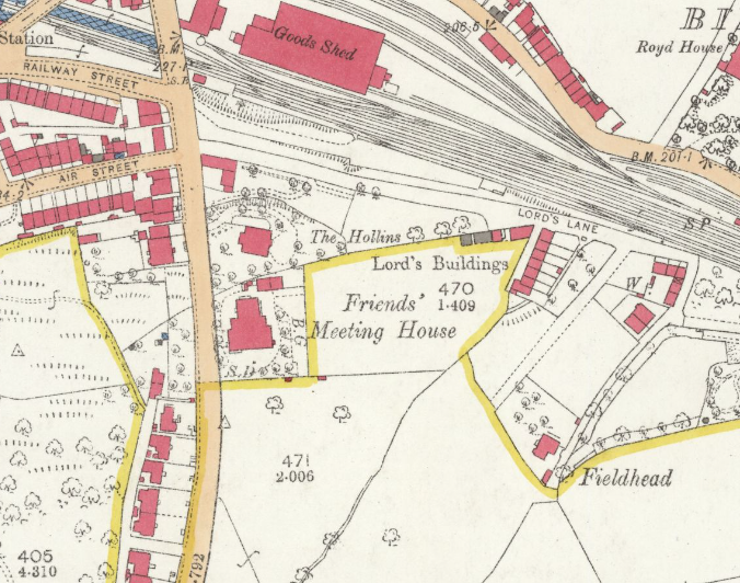
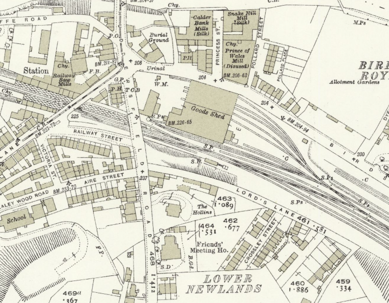
| Description | : | A Meeting House for the Brighouse Preparative Meeting of the Society of Friends at Scar Mill Cliff/Snake Hill Rastrick was acquired by 1681 and was rebuilt in 1737. A larger Friends' Meeting House was built in 1869 in the Newlands area on Huddersfield Road. The Snake Hill site was sold in the 1880s. The first recorded burial at Snake Hill was in 1701, cemetery was closed in 1880. While the burials were reportedly removed during the 1970's, the tree-covered site remains visible along the cemetery southern and eastern fenced boundaries. Documents associated with the Brighouse Preparative Meeting are... Read More |
frequently asked questions (FAQ):
-
Where is Friends Burial Ground?
Friends Burial Ground is located at Snake Hill[west end of Birds Royd Lane] Brighouse, Metropolitan Borough of Calderdale ,West Yorkshire ,England.
-
Friends Burial Ground cemetery's updated grave count on graveviews.com?
0 memorials
-
Where are the coordinates of the Friends Burial Ground?
Latitude: 53.6988100
Longitude: -1.7784100
Nearby Cemetories:
1. Friends Burial Ground
Brighouse, Metropolitan Borough of Calderdale, England
Coordinate: 53.6969200, -1.7779800
2. St. Martin’s Churchyard
Brighouse, Metropolitan Borough of Calderdale, England
Coordinate: 53.7041460, -1.7836290
3. St. Matthew's Churchyard
Rastrick, Metropolitan Borough of Calderdale, England
Coordinate: 53.6906920, -1.7917690
4. Clifton Cemetery
Clifton, Metropolitan Borough of Calderdale, England
Coordinate: 53.7022640, -1.7583680
5. St John Churchyard
Clifton, Metropolitan Borough of Calderdale, England
Coordinate: 53.7018610, -1.7572600
6. Rastrick Cemetery
Rastrick, Metropolitan Borough of Calderdale, England
Coordinate: 53.6862720, -1.7907900
7. Brighouse Cemetery
Brighouse, Metropolitan Borough of Calderdale, England
Coordinate: 53.7126470, -1.7869960
8. Huddersfield Crematorium
Huddersfield, Metropolitan Borough of Kirklees, England
Coordinate: 53.6789170, -1.7859590
9. Kirklees Priory
Kirklees, Metropolitan Borough of Kirklees, England
Coordinate: 53.6895330, -1.7376730
10. St Anne-in-the-Grove Churchyard
Southowram, Metropolitan Borough of Calderdale, England
Coordinate: 53.7090280, -1.8189630
11. St. Matthew's Old Churchyard
Lightcliffe, Metropolitan Borough of Calderdale, England
Coordinate: 53.7245690, -1.7894920
12. St. Peter's Churchyard
Hartshead Moorside, Metropolitan Borough of Kirklees, England
Coordinate: 53.7058900, -1.7303130
13. Southowram Methodist Chapelyard
Southowram, Metropolitan Borough of Calderdale, England
Coordinate: 53.7085600, -1.8260000
14. Lower Wyke Moravian Churchyard
Wyke, Metropolitan Borough of Bradford, England
Coordinate: 53.7295640, -1.7735920
15. St Thomas Churchyard
Huddersfield, Metropolitan Borough of Kirklees, England
Coordinate: 53.6776200, -1.7401200
16. Christ Church Woodhouse
Huddersfield, Metropolitan Borough of Kirklees, England
Coordinate: 53.6677310, -1.7694960
17. Christ Church Churchyard
Fartown, Metropolitan Borough of Kirklees, England
Coordinate: 53.6675400, -1.7694500
18. Deighton Methodist Chapelyard
Huddersfield, Metropolitan Borough of Kirklees, England
Coordinate: 53.6711800, -1.7518600
19. Deighton Methodist Chapelyard Extension Cemetery
Huddersfield, Metropolitan Borough of Kirklees, England
Coordinate: 53.6705000, -1.7519300
20. The Sepulchre Quaker Burial Ground
Liversedge, Metropolitan Borough of Kirklees, England
Coordinate: 53.7080290, -1.7258720
21. Park Wood Crematorium and Garden of Remembrance
Elland, Metropolitan Borough of Calderdale, England
Coordinate: 53.6936780, -1.8340910
22. St Philip and St James Church Memorial Garden
Cleckheaton, Metropolitan Borough of Kirklees, England
Coordinate: 53.7291800, -1.7481500
23. St. Mary the Virgin Churchyard
Elland, Metropolitan Borough of Calderdale, England
Coordinate: 53.6867040, -1.8378380
24. St. Mary the Virgin Churchyard
Wyke, Metropolitan Borough of Bradford, England
Coordinate: 53.7363400, -1.7715600