
| Memorials | : | 0 |
| Location | : | Harveysburg, Warren County, USA |
| Coordinate | : | 39.5030310, -84.0132390 |
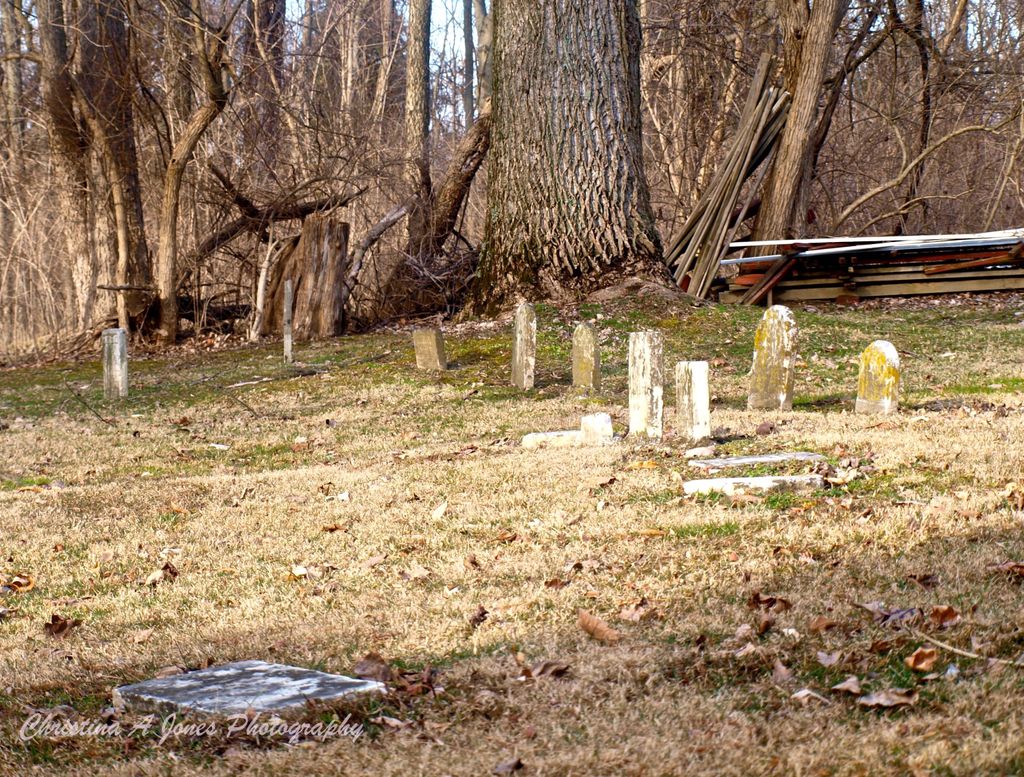
| Description | : | The first known burial in this inactive cemetery occurred in 1812. The owner of the property is listed as the Wilmington Yearly Meeting. The cemetery is at the rear of 57 West Clark Street, Harveysburg. This cemetery is in Massie Township. The cemetery is #12276 in “Ohio Cemeteries 1803-2003”, compiled by the Ohio Genealogical Society. |
frequently asked questions (FAQ):
-
Where is Friends Cemetery?
Friends Cemetery is located at 57 West Clark Street Harveysburg, Warren County ,Ohio , 45032USA.
-
Friends Cemetery cemetery's updated grave count on graveviews.com?
0 memorials
-
Where are the coordinates of the Friends Cemetery?
Latitude: 39.5030310
Longitude: -84.0132390
Nearby Cemetories:
1. Harveysburg United Brethren Cemetery
Harveysburg, Warren County, USA
Coordinate: 39.5048270, -84.0127730
2. Zion Baptist Cemetery
Harveysburg, Warren County, USA
Coordinate: 39.5024700, -84.0209450
3. Harveysburg Hicksite Cemetery
Harveysburg, Warren County, USA
Coordinate: 39.5004610, -84.0046420
4. Lukens Cemetery
Harveysburg, Warren County, USA
Coordinate: 39.4991989, -84.0267029
5. Jonahs Run Cemetery
Chester Township, Clinton County, USA
Coordinate: 39.4964490, -83.9804860
6. Massie Township Pioneer Cemetery
Harveysburg, Warren County, USA
Coordinate: 39.4821000, -84.0370100
7. Miami Cemetery
Corwin, Warren County, USA
Coordinate: 39.5217018, -84.0721970
8. Caesar Creek Cemetery
Waynesville, Warren County, USA
Coordinate: 39.5477420, -83.9835450
9. Sharon United Methodist Church Cemetery
New Burlington, Clinton County, USA
Coordinate: 39.5047830, -83.9410410
10. Mount Holly Cemetery
Mount Holly, Warren County, USA
Coordinate: 39.5630989, -84.0342026
11. Sabin Cemetery
Wilmington, Clinton County, USA
Coordinate: 39.4845680, -83.9348320
12. Friends Burial Ground
Waynesville, Warren County, USA
Coordinate: 39.5292830, -84.0882500
13. Compton Farm Cemetery
Waynesville, Warren County, USA
Coordinate: 39.5716110, -84.0043610
14. Branstator Farm Cemetery
Clarksville, Clinton County, USA
Coordinate: 39.4344690, -83.9833120
15. Brannock Cemetery
Oregonia, Warren County, USA
Coordinate: 39.4808330, -84.1027780
16. Wilkerson Cemetery
Oregonia, Warren County, USA
Coordinate: 39.4319500, -84.0332000
17. Huffman Cemetery
Oregonia, Warren County, USA
Coordinate: 39.4316220, -84.0379530
18. New Burlington Cemetery
New Burlington, Clinton County, USA
Coordinate: 39.5675201, -83.9591064
19. Springfield Friends Cemetery
Adams Township, Clinton County, USA
Coordinate: 39.4512990, -83.9375810
20. Mount Pisgah Cemetery (Defunct)
Chester Township, Clinton County, USA
Coordinate: 39.5428640, -83.9177940
21. Roxanna Cemetery (Defunct)
Spring Valley, Greene County, USA
Coordinate: 39.5867004, -84.0089035
22. Stanfield Cemetery
Clarksville, Clinton County, USA
Coordinate: 39.4264720, -83.9562220
23. Olive Branch Cemetery
Warren County, USA
Coordinate: 39.4304630, -84.0804910
24. Turtle Creek Cemetery
Turtlecreek Township, Warren County, USA
Coordinate: 39.4706001, -84.1239014