
| Memorials | : | 0 |
| Location | : | Pridgen, Coffee County, USA |
| Coordinate | : | 31.7649000, -82.9150400 |
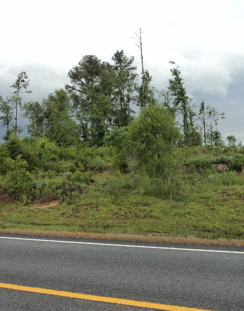
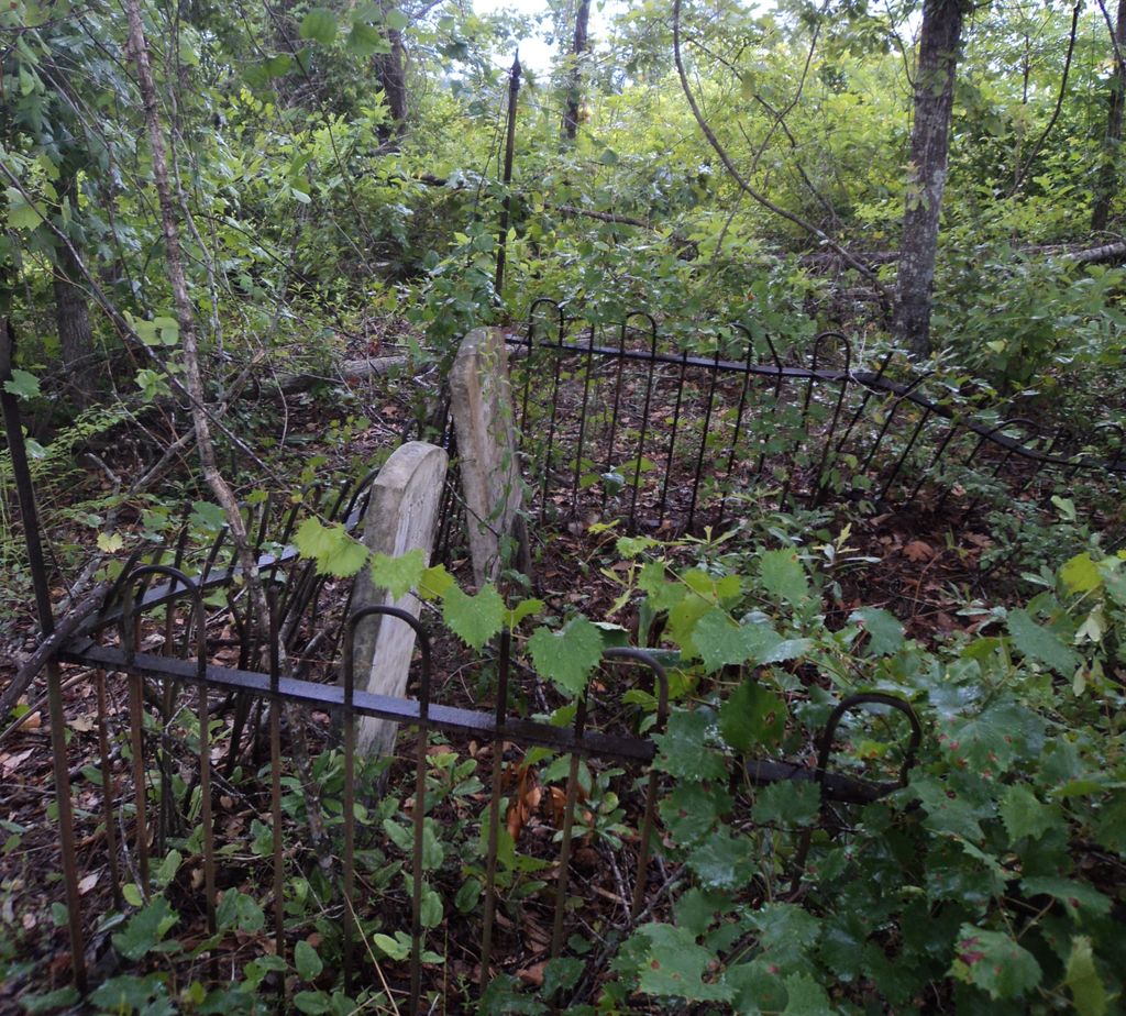
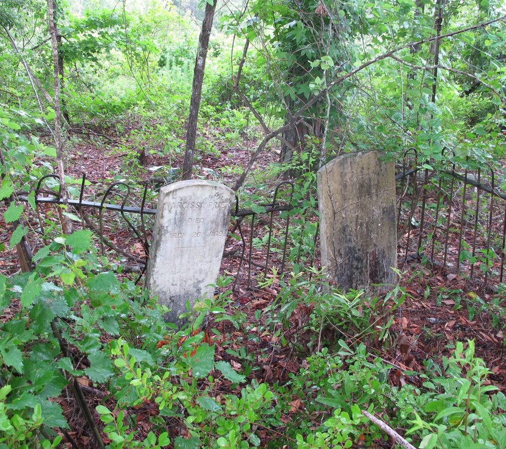
| Description | : | This Frier Cemetery is located about 75 yards off highway 107 between Snipesville and Pridgen Georgia, between the 7 and 8 mile markers. Going West on 107, it is up a hill in the trees on the right side of the road. The graves stones are in good condition, but the cemetery is overgrown with brush and hard to find. Only 3 graves are found in this cemetery. The Frier's are buried inside the fence. The other grave is very near, but outside the fence. It is the grave of a child, Mariah Harrel, daughter of Tempa and Feltz... Read More |
frequently asked questions (FAQ):
-
Where is Frier Cemetery?
Frier Cemetery is located at Pridgen, Coffee County ,Georgia ,USA.
-
Frier Cemetery cemetery's updated grave count on graveviews.com?
0 memorials
-
Where are the coordinates of the Frier Cemetery?
Latitude: 31.7649000
Longitude: -82.9150400

Nearby Cemetories:
1. Frier Cemetery
Jeff Davis County, USA
Coordinate: 31.7646999, -82.9163971
2. Oak Grove Methodist Church Cemetery
Coffee County, USA
Coordinate: 31.7616997, -82.9338989
3. Rocky Creek Cemetery
Coffee County, USA
Coordinate: 31.7572002, -82.8786011
4. Smith Family Cemetery
Pridgen, Coffee County, USA
Coordinate: 31.7667410, -82.8651950
5. Candacy Cato Cemetery
Coffee County, USA
Coordinate: 31.7082996, -82.9060974
6. Ashley-Manning-Pace Cemetery
Kirkland, Jeff Davis County, USA
Coordinate: 31.7907800, -82.8516800
7. Saint Andrews Cemetery
Coffee County, USA
Coordinate: 31.7514000, -82.8442001
8. Benjamin Chapel Cemetery
Coffee County, USA
Coordinate: 31.7355995, -82.9819031
9. Pridgen Baptist Church Cemetery
Coffee County, USA
Coordinate: 31.6972008, -82.9227982
10. Fussell Cemetery
Coffee County, USA
Coordinate: 31.7546997, -82.9961014
11. Pridgen Family Cemetery
Pridgen, Coffee County, USA
Coordinate: 31.7045100, -82.9566700
12. Pridgen Family Cemetery #1
Pridgen, Coffee County, USA
Coordinate: 31.7022200, -82.9649200
13. Fusselle Cemetery
Red Bluff, Ben Hill County, USA
Coordinate: 31.7487200, -83.0021800
14. Mobley Cemetery
Ben Hill County, USA
Coordinate: 31.7660999, -83.0113983
15. Piney Grove Baptist Church Cemetery
Hazlehurst, Jeff Davis County, USA
Coordinate: 31.7818800, -82.8050700
16. Old Union Cemetery
Red Bluff, Ben Hill County, USA
Coordinate: 31.7131004, -83.0108032
17. Saint Pauls Cemetery
Ben Hill County, USA
Coordinate: 31.7252998, -83.0192032
18. Mount Pleasant Baptist Church Cemetery
Snipesville, Jeff Davis County, USA
Coordinate: 31.7219980, -82.8118520
19. Alexander S. Mobley Cemetery
Ben Hill County, USA
Coordinate: 31.7134000, -83.0129000
20. Reedy Branch Cemetery
Broxton, Coffee County, USA
Coordinate: 31.6518993, -82.9030991
21. New Bethel Church Cemetery
Fitzgerald, Ben Hill County, USA
Coordinate: 31.7289530, -83.0423720
22. Mary's Chapel Methodist Cemetery
Broxton, Coffee County, USA
Coordinate: 31.6706800, -82.8388350
23. Carver Chapel Cemetery
Denton, Jeff Davis County, USA
Coordinate: 31.6945160, -82.8036650
24. Broxton Church of God Cemetery
Broxton, Coffee County, USA
Coordinate: 31.6459290, -82.9033470