
| Memorials | : | 1 |
| Location | : | Torrance County, USA |
| Coordinate | : | 34.7972220, -106.2352780 |
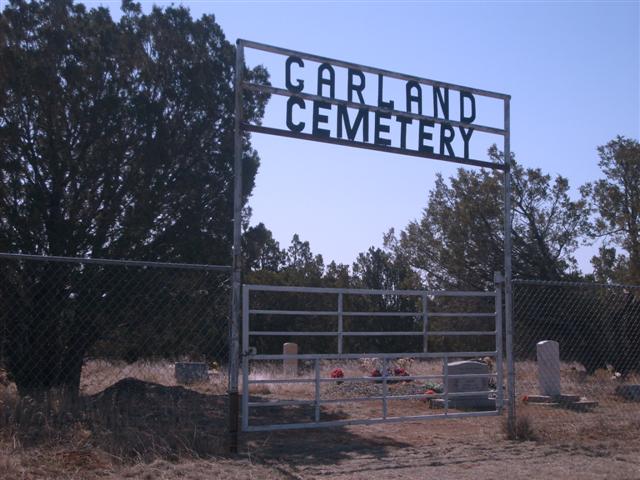
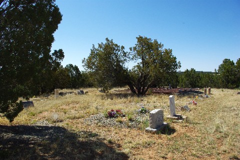
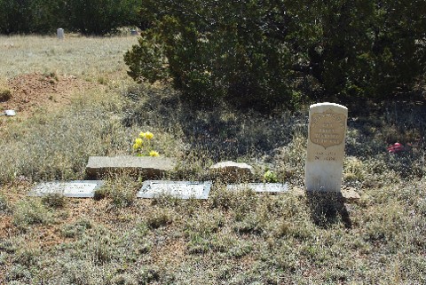
| Description | : | This cemetery is 5.4 miles south of the Bernalillo-Torrance county line on NM 337. It is eight miles south of the town of Chilili, New Mexico On 05-20-2016 the cemetery was found to be in fair shape and easily accessible. The headstones in the first couple of rows had surnames of "Garland"! As with most rural cemeteries in NM, there were possibly 20-35% unmarked graves (making it around 20 graves for Garland), or headstones that have deteriorated so badly to be unreadable. Some graves were overgrown by Mesquite, making it difficult or impossible to reach the headstone... Read More |
frequently asked questions (FAQ):
-
Where is Garland Cemetery?
Garland Cemetery is located at Torrance County ,New Mexico ,USA.
-
Garland Cemetery cemetery's updated grave count on graveviews.com?
1 memorials
-
Where are the coordinates of the Garland Cemetery?
Latitude: 34.7972220
Longitude: -106.2352780
Nearby Cemetories:
1. Urban Family Ranch Cemetery
Estancia, Torrance County, USA
Coordinate: 34.7808126, -106.2597102
2. Glover Ranch Cemetery
Tajique, Torrance County, USA
Coordinate: 34.7561500, -106.2866720
3. Tajique Catholic Church Cemetery
Tajique, Torrance County, USA
Coordinate: 34.7513640, -106.2884370
4. CLL Ranch Cemetery
Torreon, Torrance County, USA
Coordinate: 34.7207494, -106.2703326
5. Chilili New Cemetery
Chilili, Bernalillo County, USA
Coordinate: 34.8839800, -106.2229200
6. La Morada Cemetery
Chilili, Bernalillo County, USA
Coordinate: 34.8891700, -106.2337160
7. San Juan Nepomoceno
Chilili, Bernalillo County, USA
Coordinate: 34.8893350, -106.2326730
8. Saint John Nepomucene Cemetery
Torrance County, USA
Coordinate: 34.8894005, -106.2322006
9. Chilili Cemetery
Chilili, Bernalillo County, USA
Coordinate: 34.8894005, -106.2322006
10. Torreon Catholic Cemetery
Torreon, Torrance County, USA
Coordinate: 34.7213210, -106.2997510
11. Torreon Cemetery
Torreon, Torrance County, USA
Coordinate: 34.7211900, -106.2997140
12. Escabosa Cemetery
Escabosa, Bernalillo County, USA
Coordinate: 34.9253910, -106.2814520
13. Estancia Memorial Cemetery
Estancia, Torrance County, USA
Coordinate: 34.7406006, -106.0796967
14. Bosque Peak Cemetery
Torrance County, USA
Coordinate: 34.7655983, -106.4291992
15. Mount Calvary Cemetery
Torrance County, USA
Coordinate: 34.6343994, -106.2358017
16. McIntosh Cemetery
Torrance County, USA
Coordinate: 34.8647003, -106.0511017
17. Campo Santo Cemetery
Manzano, Torrance County, USA
Coordinate: 34.6507000, -106.3492000
18. Manzano Hills Cemetery
Torrance County, USA
Coordinate: 34.6467018, -106.3443985
19. Our Lady of Sorrows Catholic Cemetery
Manzano, Torrance County, USA
Coordinate: 34.6467018, -106.3443985
20. Saint Vincent De Paul Catholic Church Cemetery
Mountainair, Torrance County, USA
Coordinate: 34.5999985, -106.2833023
21. Punta de Agua Community Cemetery
Punta de Agua, Torrance County, USA
Coordinate: 34.5978080, -106.2794970
22. Martinez Cemetery
Martinez, Torrance County, USA
Coordinate: 35.0000650, -106.1994560
23. La Cienega Mission Cemetery
Torrance County, USA
Coordinate: 34.5830994, -106.3313980
24. Juan Tomas Cemetery
Juan Tomas, Bernalillo County, USA
Coordinate: 35.0273840, -106.3030600