
| Memorials | : | 332 |
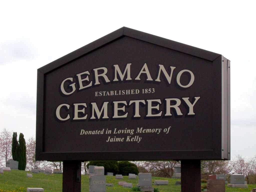
| Location | : | Germano, Harrison County, USA |
| Coordinate | : | 40.4108009, -80.9522018 |
| Description | : | The cemetery is located on the northeast side of Germano-Carrollton Road / Rumley Road East (Ohio State Route 9 / Ohio State Route 646) about 0.3 mile west of its intersection with Annapolis Road (Ohio State Route 646). The cemetery was established in 1853 and is 3.24 acres in size. The cemetery is located in German Township, Harrison County, Ohio, and is # 4988 (Germano Cemetery / New Jefferson Cemetery) in “Ohio Cemeteries 1803-2003”, compiled by the Ohio Genealogical Society. The cemetery is registered with the Ohio Division of Real Estate and Professional Licensing (ODRE) as Germano Cemetery with... Read More |
frequently asked questions (FAQ):
-
Where is Germano Cemetery?
Germano Cemetery is located at Germano-Carrollton Road / Rumley Road East Germano, Harrison County ,Ohio , 43986USA.
-
Germano Cemetery cemetery's updated grave count on graveviews.com?
332 memorials
-
Where are the coordinates of the Germano Cemetery?
Latitude: 40.4108009
Longitude: -80.9522018
Nearby Cemetories:
1. Zion Cemetery
Germano, Harrison County, USA
Coordinate: 40.4030991, -80.9238968
2. Mizer Cemetery
Amsterdam, Jefferson County, USA
Coordinate: 40.4318450, -80.9247940
3. Tedrow Cemetery
Harrison County, USA
Coordinate: 40.3857994, -80.9285965
4. Cannan Cemetery
Harrison County, USA
Coordinate: 40.3782997, -80.9431000
5. Center Unity Cemetery
Cadiz, Harrison County, USA
Coordinate: 40.3671989, -80.9486008
6. Fairview Cemetery
Jewett, Harrison County, USA
Coordinate: 40.3806000, -81.0030975
7. Buffalo Hill Cemetery
Harrison County, USA
Coordinate: 40.3911018, -80.8886032
8. Simmons Cemetery
Carroll County, USA
Coordinate: 40.4622002, -80.9783020
9. Evangelical Lutheran Cemetery
New Rumley, Harrison County, USA
Coordinate: 40.4019012, -81.0271988
10. Miller Cemetery
Springfield Township, Jefferson County, USA
Coordinate: 40.4509580, -80.8913850
11. Sproat Cemetery
Harrison County, USA
Coordinate: 40.4039001, -80.8719025
12. Kilgore Presbyterian Cemetery
Carroll County, USA
Coordinate: 40.4603004, -81.0002975
13. Blue Ridge Cemetery
Hopedale, Harrison County, USA
Coordinate: 40.3671989, -80.8949966
14. Davidson Cemetery
Springfield Township, Jefferson County, USA
Coordinate: 40.4441986, -80.8818970
15. New Rumley Methodist Cemetery
New Rumley, Harrison County, USA
Coordinate: 40.4028015, -81.0346985
16. United Brethren Cemetery
Harrison County, USA
Coordinate: 40.4043999, -81.0353012
17. Kilgore Cemetery
Kilgore, Carroll County, USA
Coordinate: 40.4632988, -81.0014038
18. Abel Cemetery
Carroll County, USA
Coordinate: 40.4578018, -81.0113983
19. Simmons Ridge Cemetery
Carroll County, USA
Coordinate: 40.4757996, -80.9621964
20. All Saints Russian Orthodox Church Cemetery
Wolf Run, Jefferson County, USA
Coordinate: 40.4598130, -80.8920900
21. Annapolis Cemetery
Salem Township, Jefferson County, USA
Coordinate: 40.4100583, -80.8636942
22. Amsterdam Cemetery
Loudon Township, Carroll County, USA
Coordinate: 40.4752998, -80.9250031
23. Smith Cemetery
Cadiz Junction, Harrison County, USA
Coordinate: 40.3428001, -80.9503021
24. Bethel Cemetery
Harrison County, USA
Coordinate: 40.3424988, -80.9518967