| Memorials | : | 0 |
| Location | : | Morris, Jefferson County, USA |
| Coordinate | : | 33.7416770, -86.8115340 |
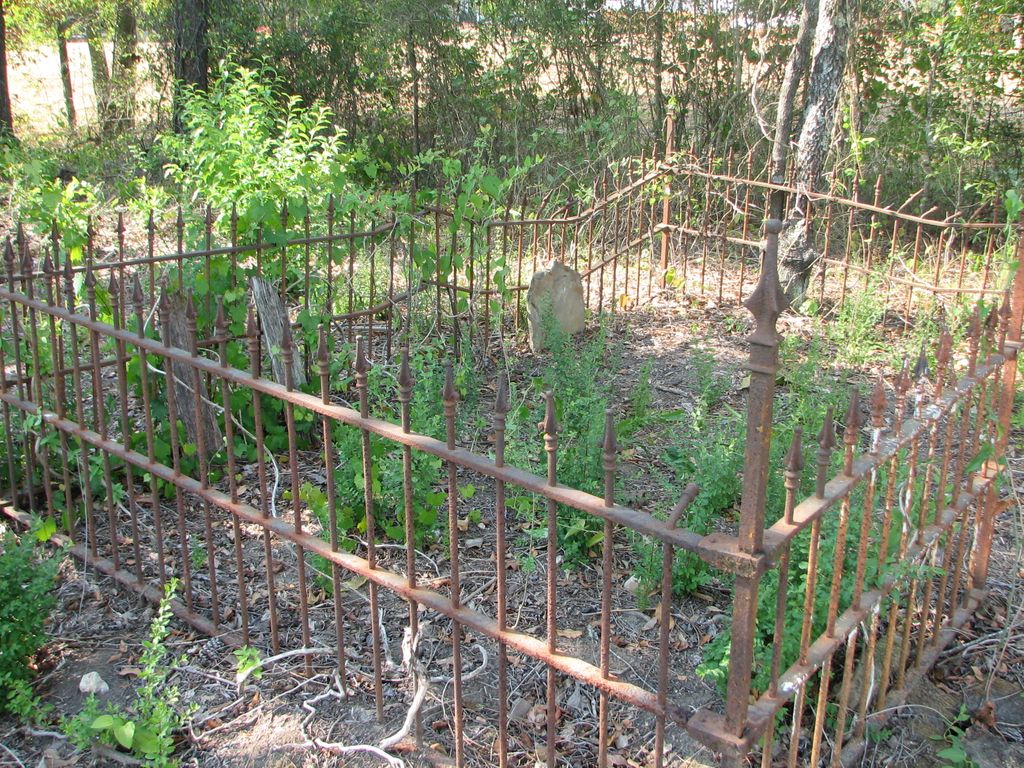
| Description | : | This old cemetery was discovered around 2007 due to construction of a new subdivision. It was overgrown and had several graves marked with rocks, but only one grave has a readable name - Louisa Gill. There is an iron fence surrounding a small area, containing the Louisa Gill sandstone tombstone along with another severely deteriorated wooden tombstone. There are a few other unmarked graves outside the iron fence. This cemetery is located in the SW quarter of the SW quarter, Sec 12 T15S R3W. This property was included in an 80 acre parcel of land originally purchased by... Read More |
frequently asked questions (FAQ):
-
Where is Gill Family Cemetery?
Gill Family Cemetery is located at Old Hwy 31 Morris, Jefferson County ,Alabama , 35116USA.
-
Gill Family Cemetery cemetery's updated grave count on graveviews.com?
0 memorials
-
Where are the coordinates of the Gill Family Cemetery?
Latitude: 33.7416770
Longitude: -86.8115340
Nearby Cemetories:
1. Jefferson County Cemetery
Morris, Jefferson County, USA
Coordinate: 33.7405720, -86.7931660
2. Morris Cemetery
Morris, Jefferson County, USA
Coordinate: 33.7569008, -86.8091965
3. Friendship United Methodist Church Cemetery
Gardendale, Jefferson County, USA
Coordinate: 33.7150002, -86.8249969
4. Haig-Rogers Cemetery
Morris, Jefferson County, USA
Coordinate: 33.7469220, -86.7735320
5. Mount Zion Church Cemetery
Kimberly, Jefferson County, USA
Coordinate: 33.7737970, -86.8084930
6. Liberty-Minter Cemetery
Morris, Jefferson County, USA
Coordinate: 33.7680016, -86.7645035
7. Edwards Cemetery
Jefferson County, USA
Coordinate: 33.6941986, -86.8116989
8. Glennwood Baptist Church Cemetery
Morris, Jefferson County, USA
Coordinate: 33.7159004, -86.7632980
9. Crooked Creek Cemetery
Jefferson County, USA
Coordinate: 33.7360992, -86.8724976
10. Creel Family Cemetery
Jefferson County, USA
Coordinate: 33.7596817, -86.7521439
11. John Belcher Cemetery
Gardendale, Jefferson County, USA
Coordinate: 33.6874100, -86.8176000
12. Castle Heights Memorial Gardens
Jefferson County, USA
Coordinate: 33.6985054, -86.7613297
13. Graham Cemetery
Mount Olive, Jefferson County, USA
Coordinate: 33.7032585, -86.8680344
14. Providence Methodist Church Cemetery
Pinson, Jefferson County, USA
Coordinate: 33.7211990, -86.7354965
15. Hughes Cemetery
Jefferson County, USA
Coordinate: 33.7528000, -86.7313995
16. Moncrief Cemetery
Gardendale, Jefferson County, USA
Coordinate: 33.6730995, -86.8139038
17. Oakwood Memorial Gardens
Gardendale, Jefferson County, USA
Coordinate: 33.6730150, -86.8158320
18. Odom Nail Cemetery
Jefferson County, USA
Coordinate: 33.7336006, -86.8965149
19. Oak Grove Baptist Church Cemetery
Pinson, Jefferson County, USA
Coordinate: 33.7197390, -86.7237230
20. Brewer Cemetery
Jefferson County, USA
Coordinate: 33.7999992, -86.8711014
21. Mount Olive Cemetery
Mount Olive, Jefferson County, USA
Coordinate: 33.6822014, -86.8707962
22. McCombs-Donegan Cemetery
Bradford, Jefferson County, USA
Coordinate: 33.7520422, -86.7075942
23. Turkey Creek Missionary Baptist Church Cemetery
Pinson, Jefferson County, USA
Coordinate: 33.7089958, -86.7111588
24. Union Missionary Baptist Cemetery
Partridge Crossroads, Jefferson County, USA
Coordinate: 33.7633018, -86.9317017

