
| Memorials | : | 0 |
| Location | : | Gardendale, Jefferson County, USA |
| Coordinate | : | 33.6874100, -86.8176000 |
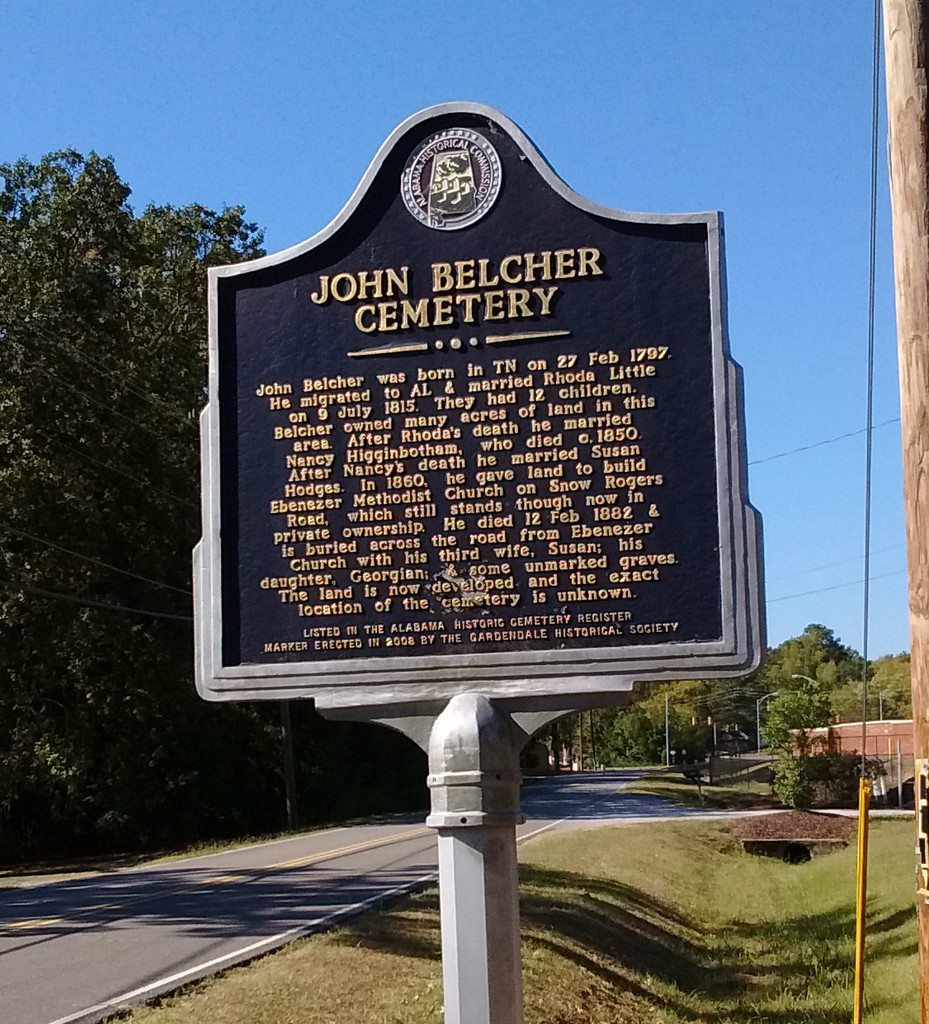
| Description | : | According to the historical marker, a local business has now been built over the family cemetery. The marker is across from the Revealed Word Worship Center which is housed in the former Ebenezer Methodist Church on Snow Rogers Road. |
frequently asked questions (FAQ):
-
Where is John Belcher Cemetery?
John Belcher Cemetery is located at 2574 Snow Rogers Road Gardendale, Jefferson County ,Alabama , 35071USA.
-
John Belcher Cemetery cemetery's updated grave count on graveviews.com?
0 memorials
-
Where are the coordinates of the John Belcher Cemetery?
Latitude: 33.6874100
Longitude: -86.8176000
Nearby Cemetories:
1. Edwards Cemetery
Jefferson County, USA
Coordinate: 33.6941986, -86.8116989
2. Oakwood Memorial Gardens
Gardendale, Jefferson County, USA
Coordinate: 33.6730150, -86.8158320
3. Moncrief Cemetery
Gardendale, Jefferson County, USA
Coordinate: 33.6730995, -86.8139038
4. Friendship United Methodist Church Cemetery
Gardendale, Jefferson County, USA
Coordinate: 33.7150002, -86.8249969
5. Mount Olive Cemetery
Mount Olive, Jefferson County, USA
Coordinate: 33.6822014, -86.8707962
6. Graham Cemetery
Mount Olive, Jefferson County, USA
Coordinate: 33.7032585, -86.8680344
7. Castle Heights Memorial Gardens
Jefferson County, USA
Coordinate: 33.6985054, -86.7613297
8. Glennwood Baptist Church Cemetery
Morris, Jefferson County, USA
Coordinate: 33.7159004, -86.7632980
9. Gill Family Cemetery
Morris, Jefferson County, USA
Coordinate: 33.7416770, -86.8115340
10. Jefferson County Cemetery
Morris, Jefferson County, USA
Coordinate: 33.7405720, -86.7931660
11. Cluster Springs Cemetery
Gardendale, Jefferson County, USA
Coordinate: 33.6302986, -86.8323975
12. New Castle Cemetery
New Castle, Jefferson County, USA
Coordinate: 33.6404300, -86.7732400
13. Crooked Creek Cemetery
Jefferson County, USA
Coordinate: 33.7360992, -86.8724976
14. Morris Cemetery
Morris, Jefferson County, USA
Coordinate: 33.7569008, -86.8091965
15. Haig-Rogers Cemetery
Morris, Jefferson County, USA
Coordinate: 33.7469220, -86.7735320
16. Providence Methodist Church Cemetery
Pinson, Jefferson County, USA
Coordinate: 33.7211990, -86.7354965
17. Odom Nail Cemetery
Jefferson County, USA
Coordinate: 33.7336006, -86.8965149
18. Hodges Cemetery
Jefferson County, USA
Coordinate: 33.6225014, -86.8743973
19. Pawnee Missionary Baptist Church Cemetery
Birmingham, Jefferson County, USA
Coordinate: 33.6302170, -86.7480170
20. Walker Chapel Memorial Gardens
Fultondale, Jefferson County, USA
Coordinate: 33.6046982, -86.8171997
21. Oak Grove Baptist Church Cemetery
Pinson, Jefferson County, USA
Coordinate: 33.7197390, -86.7237230
22. Mount Zion Church Cemetery
Kimberly, Jefferson County, USA
Coordinate: 33.7737970, -86.8084930
23. Green Cemetery
Pinson, Jefferson County, USA
Coordinate: 33.6545660, -86.7176840
24. Creel Family Cemetery
Jefferson County, USA
Coordinate: 33.7596817, -86.7521439