
| Memorials | : | 0 |
| Location | : | Asheboro, Randolph County, USA |
| Coordinate | : | 35.6285300, -79.7079600 |
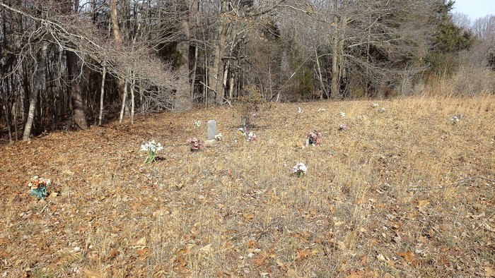
| Description | : | This cemetery sets on the side of Old NC Hwy 13, there is only one actual tombstone that has information. There are approx. 20-25 other graves marked by flowers and field quartz. |
frequently asked questions (FAQ):
-
Where is Goins Family Cemetery?
Goins Family Cemetery is located at Asheboro, Randolph County ,North Carolina ,USA.
-
Goins Family Cemetery cemetery's updated grave count on graveviews.com?
0 memorials
-
Where are the coordinates of the Goins Family Cemetery?
Latitude: 35.6285300
Longitude: -79.7079600
Nearby Cemetories:
1. Union Grove Christian Church Cemetery
Asheboro, Randolph County, USA
Coordinate: 35.6235200, -79.7106600
2. Panther Creek Baptist Church Cemetery
Asheboro, Randolph County, USA
Coordinate: 35.6176300, -79.7437820
3. Piney Ridge UMC Cemetery
Seagrove, Randolph County, USA
Coordinate: 35.5898720, -79.6944330
4. Bethel Friends Cemetery
Asheboro, Randolph County, USA
Coordinate: 35.6645700, -79.7391200
5. Shiloh Baptist Church Cemetery
Ramseur, Randolph County, USA
Coordinate: 35.6115112, -79.6561737
6. Richland Baptist Church Cemetery
Asheboro, Randolph County, USA
Coordinate: 35.6543740, -79.7559120
7. Mountain of Faith Christian Church Cemetery
Asheboro, Randolph County, USA
Coordinate: 35.6760930, -79.7129830
8. Stouts Chapel UMC Cemetery
Ramseur, Randolph County, USA
Coordinate: 35.6647210, -79.6646660
9. Spoons Chapel United Church of Christ Cemetery
Asheboro, Randolph County, USA
Coordinate: 35.6763150, -79.7345110
10. Holly Spring Friends Meeting Cemetery
Ramseur, Randolph County, USA
Coordinate: 35.6697270, -79.6676470
11. Pleasant Hill United Methodist Church
Seagrove, Randolph County, USA
Coordinate: 35.5732574, -79.7067261
12. Mount Tabor Community Church Cemetery
Asheboro, Randolph County, USA
Coordinate: 35.6892900, -79.7318400
13. Mitchell United Methodist Church Cemetery #1
Asheboro, Randolph County, USA
Coordinate: 35.6233300, -79.7910600
14. Deep River Baptist Church Cemetery
Ramseur, Randolph County, USA
Coordinate: 35.6388700, -79.6247100
15. Mitchell United Methodist Church Cemetery #2
Asheboro, Randolph County, USA
Coordinate: 35.6221700, -79.7929700
16. Antioch Christian Church Cemetery
Seagrove, Randolph County, USA
Coordinate: 35.5847980, -79.6361780
17. Huldah Baptist Church Cemetery
Asheboro, Randolph County, USA
Coordinate: 35.5779360, -79.7753080
18. Spencer Family Cemetery
Seagrove, Randolph County, USA
Coordinate: 35.5528110, -79.7310880
19. Browers Chapel UMC Cemetery
Asheboro, Randolph County, USA
Coordinate: 35.6747290, -79.7854000
20. Mill Creek Friends Cemetery
Asheboro, Randolph County, USA
Coordinate: 35.6922270, -79.6463380
21. Flag Springs United Methodist Church Cemetery
Asheboro, Randolph County, USA
Coordinate: 35.6102860, -79.8068910
22. Pleasant Ridge Christian Church Cemetery
Ramseur, Randolph County, USA
Coordinate: 35.7046860, -79.6670060
23. Richard Graves Family Cemetery
Seagrove, Randolph County, USA
Coordinate: 35.5611100, -79.7679100
24. Mount Olivet United Methodist Church Cemetery
Coleridge, Randolph County, USA
Coordinate: 35.5527400, -79.6593200