
| Memorials | : | 5 |
| Location | : | Turakina, Rangitikei District, New Zealand |
| Coordinate | : | -40.0625400, 175.2258200 |
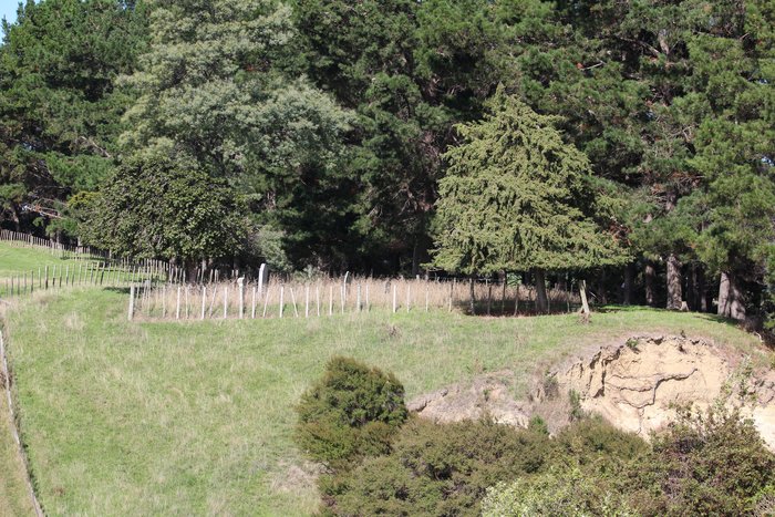
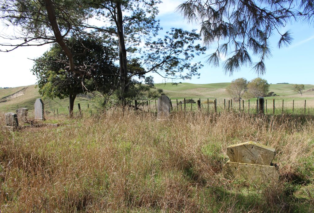
| Description | : | This Private Cemetery is on the land which was settled and first owned by Donald "Cooper” or “Bane” Cameron. It is situated above the Makirikiri Stream near State Highway 3 to Wanganui, just before Turakina. There are thought to be 26 burials dating from 1851 in here and there are 7 Headstones dating from 1876. "It has been truly said that the early settlers require no memorial for "if we look around we see their monuments." Unfortunately, however, the later day colonist does not "look around," he is too much occupied in the rush of life or sport to think of those who... Read More |
frequently asked questions (FAQ):
-
Where is Grant Family Makirikiri Cemetery?
Grant Family Makirikiri Cemetery is located at Turakina, Rangitikei District ,Manawatū-Whanganui ,New Zealand.
-
Grant Family Makirikiri Cemetery cemetery's updated grave count on graveviews.com?
5 memorials
-
Where are the coordinates of the Grant Family Makirikiri Cemetery?
Latitude: -40.0625400
Longitude: 175.2258200
Nearby Cemetories:
1. Turakina Catholic Cemetery
Turakina, Rangitikei District, New Zealand
Coordinate: -40.0453000, 175.2239600
2. Turakina Cemetery
Turakina, Rangitikei District, New Zealand
Coordinate: -40.0461300, 175.2140160
3. Te Mangungu Churchyard
Turakina, Rangitikei District, New Zealand
Coordinate: -40.0633110, 175.1818200
4. Ratana Cemetery
Ratana, Rangitikei District, New Zealand
Coordinate: -40.0311470, 175.1771200
5. Bonny Glen Cemetery
Marton, Rangitikei District, New Zealand
Coordinate: -40.0496200, 175.3410200
6. Marton Lutheran Cemetery Tutaenui
Marton, Rangitikei District, New Zealand
Coordinate: -40.0772400, 175.3692700
7. Matarawa Cemetery
Fordell, Whanganui District, New Zealand
Coordinate: -39.9468100, 175.1452700
8. Matarawa Presbyterian Cemetery
Whanganui, Whanganui District, New Zealand
Coordinate: -39.9461300, 175.1433100
9. Kauangaroa Pa Cemetery
Kauangaroa, Whanganui District, New Zealand
Coordinate: -39.9231800, 175.2788000
10. Upper Tutaenui Cemetery
Marton, Rangitikei District, New Zealand
Coordinate: -40.0086900, 175.4093900
11. Mount View Cemetery
Marton, Rangitikei District, New Zealand
Coordinate: -40.0631570, 175.4252250
12. St Stephens Anglican Cemetery
Marton, Rangitikei District, New Zealand
Coordinate: -40.0618230, 175.4258020
13. Fraser Family Cemetery
Bulls, Rangitikei District, New Zealand
Coordinate: -40.2000380, 175.3294560
14. Greatford Cemetery
Greatford, Rangitikei District, New Zealand
Coordinate: -40.1260100, 175.4175700
15. Parewanui Presbyterian Cemetery
Tangimoana, Manawatu District, New Zealand
Coordinate: -40.2229440, 175.3061780
16. Clifton Cemetery
Bulls, Rangitikei District, New Zealand
Coordinate: -40.1752170, 175.4002900
17. Putiki Urupā
Whanganui District, New Zealand
Coordinate: -39.9466140, 175.0499350
18. Heads Road Cemetery
Whanganui, Whanganui District, New Zealand
Coordinate: -39.9393300, 175.0473400
19. Wheriko Anglican Church Cemetery
Bulls, Rangitikei District, New Zealand
Coordinate: -40.2322588, 175.3195457
20. Bulls Māori Cemetery
Bulls, Rangitikei District, New Zealand
Coordinate: -40.1841400, 175.4092600
21. St John's Anglican Church Cemetery
Marton, Rangitikei District, New Zealand
Coordinate: -40.0298860, 175.4759430
22. Aramoho Cemetery
Whanganui, Whanganui District, New Zealand
Coordinate: -39.8926494, 175.0922441
23. Tokorangi Urupā
Halcombe, Manawatu District, New Zealand
Coordinate: -40.0856300, 175.4894900
24. St. Mary's Anglican Church Cemetery
Upokongaro, Whanganui District, New Zealand
Coordinate: -39.8656100, 175.1132820