
| Memorials | : | 0 |
| Location | : | Columbia, Boone County, USA |
| Coordinate | : | 38.9457300, -92.4732400 |
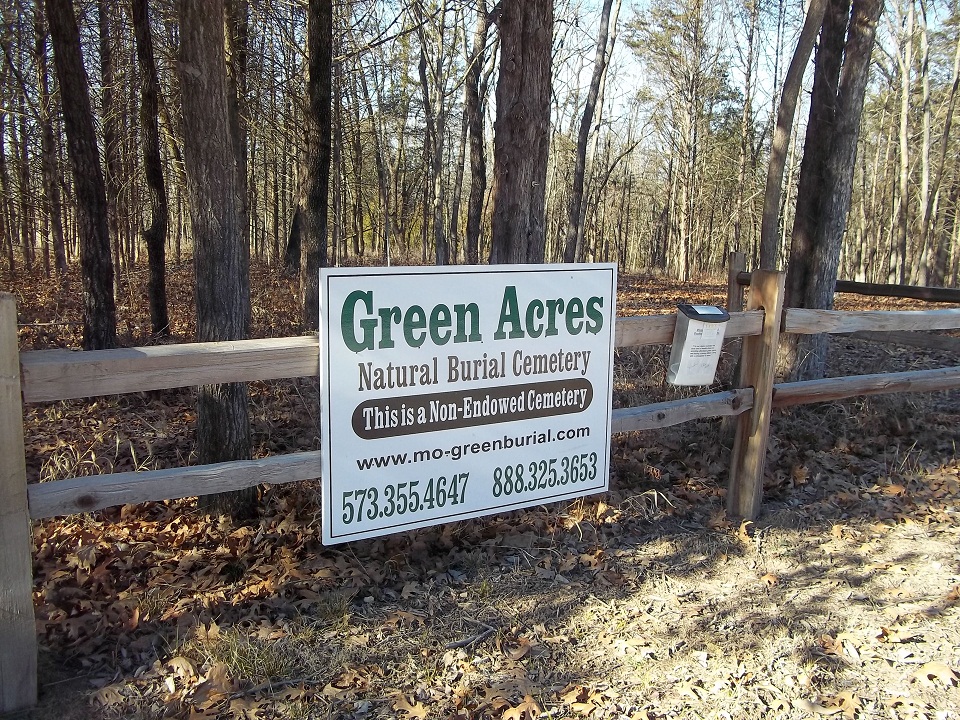
| Description | : | 1406 Hickory Grove School Road (across the street from Sugar Creek Cemetery off Hwy UU). The first green cemetery in Missouri is being developed west of Columbia by Bill Goddard and Chuck Worstell to offer cheaper burials and an environmentally friendly alternative to traditional burials. Green Acres will follow burial criteria established by the Green Burial Council, a nonprofit organization based in Sante Fe, N.M. These include no embalming, no vaults and a requirement that the body be buried directly into the ground in a biodegradable and nontoxic shroud or coffin. Goddard said two types of people will be interested... Read More |
frequently asked questions (FAQ):
-
Where is Green Acres Cemetery?
Green Acres Cemetery is located at Columbia, Boone County ,Missouri ,USA.
-
Green Acres Cemetery cemetery's updated grave count on graveviews.com?
0 memorials
-
Where are the coordinates of the Green Acres Cemetery?
Latitude: 38.9457300
Longitude: -92.4732400
Nearby Cemetories:
1. Sugar Creek Cemetery
Huntsdale, Boone County, USA
Coordinate: 38.9455986, -92.4721985
2. Rural Jordan Cemetery
Rocheport, Boone County, USA
Coordinate: 38.9626376, -92.4810337
3. Mount Nebo Cemetery
Boone County, USA
Coordinate: 38.9239006, -92.4610977
4. Valley Springs Cemetery
Columbia, Boone County, USA
Coordinate: 38.9486008, -92.4424973
5. Cochran Family Cemetery
Boone County, USA
Coordinate: 38.9724560, -92.4861290
6. Locust Grove Cemetery
Midway, Boone County, USA
Coordinate: 38.9855120, -92.4485580
7. Wooldridge Cemetery
Wooldridge, Cooper County, USA
Coordinate: 38.9086000, -92.5228850
8. Yahweh's Assembly In Messiah Cemetery
Rocheport, Boone County, USA
Coordinate: 38.9611995, -92.5397969
9. Goodin Cemetery
Boone County, USA
Coordinate: 38.9406400, -92.4025000
10. Conley Cemetery
Boone County, USA
Coordinate: 38.8885994, -92.4357986
11. Copps Chapel Cemetery
Moniteau County, USA
Coordinate: 38.8838100, -92.5042500
12. Lientz Cemetery
Midway, Boone County, USA
Coordinate: 39.0080400, -92.5050200
13. Sprinkle Family Cemetery
Columbia, Boone County, USA
Coordinate: 38.9321100, -92.3854700
14. Fairview Cemetery
Columbia, Boone County, USA
Coordinate: 38.9354930, -92.3801810
15. Broadway Christian Church Memorial Garden
Columbia, Boone County, USA
Coordinate: 38.9558000, -92.3779200
16. Rocheport City Cemetery
Rocheport, Boone County, USA
Coordinate: 38.9809050, -92.5590420
17. Walnut Grove Cemetery
Rocheport, Boone County, USA
Coordinate: 39.0125008, -92.5233002
18. Clayton Cemetery
Overton, Cooper County, USA
Coordinate: 38.9427986, -92.5744019
19. Mount Celestial Church Cemetery
McBaine, Boone County, USA
Coordinate: 38.8762100, -92.4198600
20. Pettigrew Cemetery
Moniteau County, USA
Coordinate: 38.8643990, -92.4747009
21. New Providence Cemetery
Columbia, Boone County, USA
Coordinate: 39.0071500, -92.4019100
22. Goochs Mill Baptist Church Cemetery
Boonville, Cooper County, USA
Coordinate: 38.9002890, -92.5777260
23. New Salem Missionary Baptist Church Cemetery
Cooper County, USA
Coordinate: 38.8990990, -92.5782040
24. Courtyard Memorial Garden
Columbia, Boone County, USA
Coordinate: 38.9418880, -92.3524030