
| Memorials | : | 0 |
| Location | : | Jefferson County, USA |
| Coordinate | : | 41.3184000, -79.1440000 |
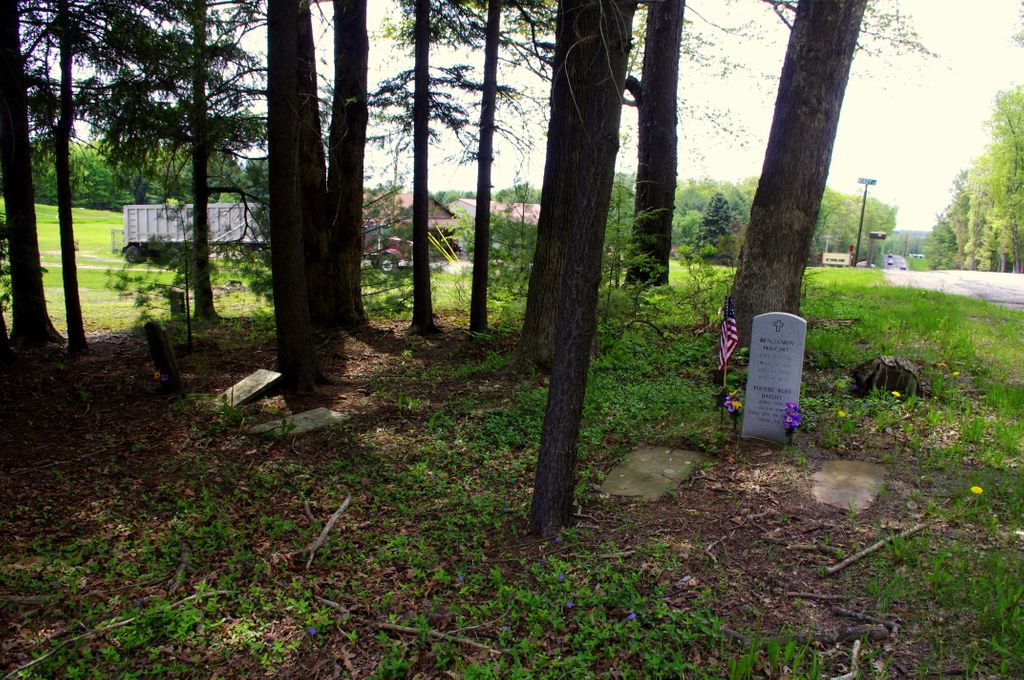
| Description | : | This small cemetery is located along Route 36 between Sigel and Cooks Forest - 4.3 miles east of the Clarion River. |
frequently asked questions (FAQ):
-
Where is Haight - Wing Family Cemetery?
Haight - Wing Family Cemetery is located at Jefferson County ,Pennsylvania ,USA.
-
Haight - Wing Family Cemetery cemetery's updated grave count on graveviews.com?
0 memorials
-
Where are the coordinates of the Haight - Wing Family Cemetery?
Latitude: 41.3184000
Longitude: -79.1440000

Nearby Cemetories:
1. Daniels Cemetery
Port Barnett, Jefferson County, USA
Coordinate: 41.3183817, -79.1300323
2. Clarington Methodist Cemetery
Clarington, Forest County, USA
Coordinate: 41.3353000, -79.1197000
3. Hominy Ridge Cemetery
Sigel, Jefferson County, USA
Coordinate: 41.3128014, -79.1808014
4. Maze Cemetery
Hottelville, Forest County, USA
Coordinate: 41.3470947, -79.1846251
5. Cooksburg Cemetery
Forest County, USA
Coordinate: 41.3293991, -79.1980972
6. Kahletown Cemetery
Kahletown, Jefferson County, USA
Coordinate: 41.2720000, -79.1588000
7. Donehey Cemetery
Sigel, Jefferson County, USA
Coordinate: 41.2744950, -79.1093610
8. Blue Ridge Cemetery
Forest County, USA
Coordinate: 41.3594017, -79.1025009
9. Mount Tabor Cemetery
Sigel, Jefferson County, USA
Coordinate: 41.2655983, -79.1231003
10. Saint Dominics Cemetery
Sigel, Jefferson County, USA
Coordinate: 41.2619019, -79.1318970
11. Greenwood Cemetery
Forest County, USA
Coordinate: 41.3808000, -79.1904000
12. Edeburn Hill Cemetery
Jefferson County, USA
Coordinate: 41.3369000, -79.0498000
13. Redclyffe Methodist Cemetery
Forest County, USA
Coordinate: 41.4019000, -79.1538000
14. Fisher Presbyterian Cemetery
Fisher, Clarion County, USA
Coordinate: 41.2648000, -79.2413000
15. Scotch Hill Union Cemetery
Scotch Hill, Clarion County, USA
Coordinate: 41.3240000, -79.2651000
16. Fisher Methodist Cemetery
Fisher, Clarion County, USA
Coordinate: 41.2587000, -79.2445000
17. Pine Grove Cemetery
Corsica, Jefferson County, USA
Coordinate: 41.2182999, -79.1830978
18. Saint Mary's Cemetery
Crown, Clarion County, USA
Coordinate: 41.3908000, -79.2564000
19. Donahey Hill Cemetery
Belltown, Elk County, USA
Coordinate: 41.3745400, -79.0065100
20. Gilfoyle Methodist Church Cemetery
Gilfoyle, Forest County, USA
Coordinate: 41.4391230, -79.1819000
21. Zion Sigel Road Cemetery
Howe, Jefferson County, USA
Coordinate: 41.1967302, -79.1075377
22. Moorhead Cemetery
Jefferson County, USA
Coordinate: 41.2397200, -79.0116400
23. Anderson Farm Cemetery
Leeper, Clarion County, USA
Coordinate: 41.3592530, -79.3047000
24. Richardsville Baptist Cemetery
Richardsville, Jefferson County, USA
Coordinate: 41.2365000, -79.0122000