
| Memorials | : | 0 |
| Location | : | Franklin County, USA |
| Coordinate | : | 34.2946650, -83.2667540 |
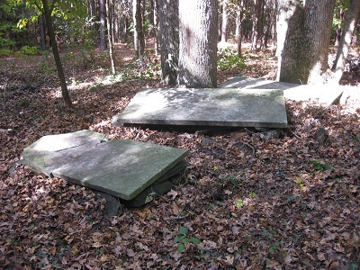
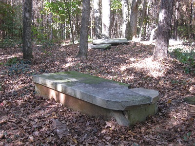
| Description | : | Located deep in a planted pine grove several hundred yards from the "Neal Little Road" in Franklin County, Georgia. The recent logging operation left a number of tall trees in and around the cemetery. This will help you locate the graves on a slight knoll. G.P.S. Location: 34.171342N - 83.16.8W. Please follow "Find A Grave" links to see an interesting glimpse into the life and death of one of "Luday" Haley's sons Meeks Haley #30856941 and his wife Rose Ann Gregg Haley #31056338 of Gallatin County, Illinois. (William Carson) |
frequently asked questions (FAQ):
-
Where is Haley Family Cemetery?
Haley Family Cemetery is located at Neal Little Road, West of Georgia Hwy. 51 Franklin County ,Georgia ,USA.
-
Haley Family Cemetery cemetery's updated grave count on graveviews.com?
0 memorials
-
Where are the coordinates of the Haley Family Cemetery?
Latitude: 34.2946650
Longitude: -83.2667540
Nearby Cemetories:
1. Trinity United Methodist Church Cemetery
Franklin County, USA
Coordinate: 34.2803280, -83.2662940
2. Little Family Cemetery
Carnesville, Franklin County, USA
Coordinate: 34.2959410, -83.2898860
3. Gordon Non Denomination
Franklin County, USA
Coordinate: 34.2716770, -83.2726670
4. Blackwell Family Cemetery
Carnesville, Franklin County, USA
Coordinate: 34.3203810, -83.2558360
5. Peniel Pentecostal Holiness Cemetery
Royston, Franklin County, USA
Coordinate: 34.2880650, -83.2283770
6. Middle River Cemetery
Carnesville, Franklin County, USA
Coordinate: 34.3274100, -83.2698880
7. Peniel Church Cemetery #2
Sandy Cross, Franklin County, USA
Coordinate: 34.2882476, -83.2268702
8. Melvin Hill Christian Methodist Episcopal Church
Carnesville, Franklin County, USA
Coordinate: 34.2699030, -83.2947440
9. Holbrook Cemetery
Cromers, Franklin County, USA
Coordinate: 34.3216667, -83.2925000
10. Pennington Chapel Cemetery
Franklin County, USA
Coordinate: 34.2870700, -83.2242530
11. Rocky Branch Cemetery
Carnesville, Franklin County, USA
Coordinate: 34.3351410, -83.2666200
12. Cary Memorial Garden
Royston, Franklin County, USA
Coordinate: 34.2908530, -83.2160390
13. Riverside Church Cemetery
Sandy Cross, Franklin County, USA
Coordinate: 34.3164749, -83.2170792
14. Zidon Baptist Church Cemetery
Sandy Cross, Franklin County, USA
Coordinate: 34.2824326, -83.2111359
15. Crow-Phillips Cemetery
Franklin County, USA
Coordinate: 34.3177986, -83.2161026
16. Crow, Roach, Phillips Family Cemetery
Sandy Cross, Franklin County, USA
Coordinate: 34.3175530, -83.2152440
17. Liberty Church Cemetery
Ila, Madison County, USA
Coordinate: 34.2456690, -83.2726490
18. Martin Family Cemetery
Carnesville, Franklin County, USA
Coordinate: 34.2723618, -83.3202286
19. Harber Family Cemetery
Carnesville, Franklin County, USA
Coordinate: 34.3334760, -83.3065940
20. Buckey James Cemetery
Royston, Franklin County, USA
Coordinate: 34.2612720, -83.2192170
21. Bold Springs Methodist Church Cemetery
Carnesville, Franklin County, USA
Coordinate: 34.2953050, -83.3346660
22. Hebron Presbyterian Church Original Cemetery
Carnesville, Franklin County, USA
Coordinate: 34.2859920, -83.3465770
23. McEwen Family Cemetery
Danielsville, Madison County, USA
Coordinate: 34.2331240, -83.2251100
24. Carson Road Family Cemetery
Carnesville, Franklin County, USA
Coordinate: 34.3284210, -83.3418420