
| Memorials | : | 1 |
| Location | : | Carnesville, Franklin County, USA |
| Coordinate | : | 34.2859920, -83.3465770 |
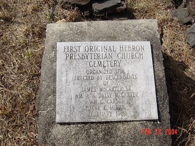
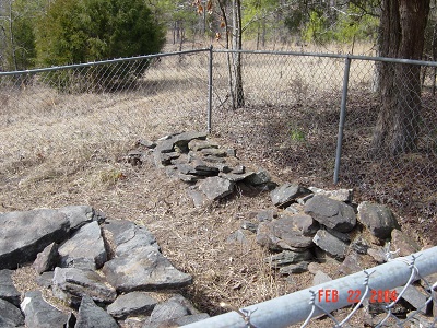
| Description | : | Guide to the Original Cemetery: Directions from Hebron Presbyterian Church to the Original Cemetery-(Because of the lack of landmarks, it is far better to take someone with you who knows the location of the Original Cemetery. Note that the nearest resident objects to people parking in their front yard when you visit the Cemetery, so be sure to park along the shoulder of the road.) Turn left on the paved road that passes by Hebron Presbyterian Church. Continue .7 mile until this road ends into Bold Spring Road. Take a right and continue 1.6 miles. ... Read More |
frequently asked questions (FAQ):
-
Where is Hebron Presbyterian Church Original Cemetery?
Hebron Presbyterian Church Original Cemetery is located at off of Hwy. #326 in the Bold Spring Community Carnesville, Franklin County ,Georgia ,USA.
-
Hebron Presbyterian Church Original Cemetery cemetery's updated grave count on graveviews.com?
1 memorials
-
Where are the coordinates of the Hebron Presbyterian Church Original Cemetery?
Latitude: 34.2859920
Longitude: -83.3465770
Nearby Cemetories:
1. Bold Springs Methodist Church Cemetery
Carnesville, Franklin County, USA
Coordinate: 34.2953050, -83.3346660
2. Hebron Presbyterian Cemetery
Hebron, Banks County, USA
Coordinate: 34.2855988, -83.3644028
3. Martin Family Cemetery
Carnesville, Franklin County, USA
Coordinate: 34.2723618, -83.3202286
4. John Sewell Family Cemetery
Banks County, USA
Coordinate: 34.2594528, -83.3486481
5. Goss Family Cemetery
Ashland, Franklin County, USA
Coordinate: 34.3064000, -83.3683800
6. Shannon Family Cemetery
Ashland, Franklin County, USA
Coordinate: 34.3134670, -83.3495670
7. Hudson River Baptist Church Cemetery
Carnesville, Franklin County, USA
Coordinate: 34.2528670, -83.3379040
8. Neal-Adams Family Cemetery
Ashland, Franklin County, USA
Coordinate: 34.3192700, -83.3585100
9. Arnolds Chapel C.M.E. Church Cemetery
Ashland, Franklin County, USA
Coordinate: 34.3216230, -83.3637430
10. Ebenezer Cemetery
Franklin County, USA
Coordinate: 34.3236008, -83.3572006
11. Neal Family Cemetery
Banks County, USA
Coordinate: 34.2660210, -83.3873460
12. Neals Grove Baptist Church Cemetery
Hebron, Banks County, USA
Coordinate: 34.2754820, -83.3945780
13. Burgess Cemetery
Banks County, USA
Coordinate: 34.2447200, -83.3555700
14. Carson Road Family Cemetery
Carnesville, Franklin County, USA
Coordinate: 34.3284210, -83.3418420
15. Sims Family Cemetery
Banks County, USA
Coordinate: 34.2564200, -83.3848400
16. Melvin Hill Christian Methodist Episcopal Church
Carnesville, Franklin County, USA
Coordinate: 34.2699030, -83.2947440
17. Arendall Family Cemetery
Franklin County, USA
Coordinate: 34.3319950, -83.3433360
18. Adam's Place Cemetery
Banks County, USA
Coordinate: 34.3166830, -83.3901750
19. Little Family Cemetery
Carnesville, Franklin County, USA
Coordinate: 34.2959410, -83.2898860
20. Tucker Family Cemetery
Ashland, Franklin County, USA
Coordinate: 34.3350900, -83.3402250
21. Westbrook Family Cemetery
Franklin County, USA
Coordinate: 34.3319020, -83.3717910
22. Holbrook Cemetery
Cromers, Franklin County, USA
Coordinate: 34.3216667, -83.2925000
23. Harber Family Cemetery
Carnesville, Franklin County, USA
Coordinate: 34.3334760, -83.3065940
24. New Salem Cemetery
Banks County, USA
Coordinate: 34.2827988, -83.4169006