
| Memorials | : | 37 |
| Location | : | Harwell, Vale of White Horse District, England |
| Coordinate | : | 51.5985200, -1.2885900 |
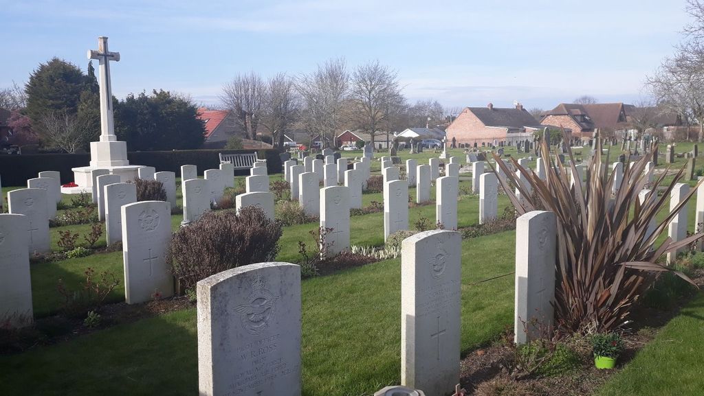
| Description | : | The Commonwealth War Graves Plot within Harwell Village Cemetery contains sixty six World War Two Burials and one World War One burial. An additional RN grave lies within the cemetery. The World War Two burials are almost exclusively RAF burials from those who served at nearby RAF Harwell. The site of the old base is now occupied by the Atomic Energy Research Establishment Harwell. Harwell village is in south Oxfordshire alongside the A417 which runs east to west with most of the village north of the road. The village also lies close to the A34 main north south trunk road. The... Read More |
frequently asked questions (FAQ):
-
Where is Harwell Cemetery?
Harwell Cemetery is located at Harwell, Vale of White Horse District ,Oxfordshire ,England.
-
Harwell Cemetery cemetery's updated grave count on graveviews.com?
37 memorials
-
Where are the coordinates of the Harwell Cemetery?
Latitude: 51.5985200
Longitude: -1.2885900

Nearby Cemetories:
1. Saint Matthews Churchyard
Harwell, Vale of White Horse District, England
Coordinate: 51.5983510, -1.2908880
2. All Saints Churchyard
Didcot, South Oxfordshire District, England
Coordinate: 51.6107791, -1.2508990
3. St Andrew Church Cemetery
East Hagbourne, South Oxfordshire District, England
Coordinate: 51.5912000, -1.2460500
4. Didcot Cemetery
Didcot, South Oxfordshire District, England
Coordinate: 51.6033500, -1.2438400
5. St. Andrew Churchyard
East Hagbourne, South Oxfordshire District, England
Coordinate: 51.5902000, -1.2430000
6. St Andrew's Church
East Hagbourne, South Oxfordshire District, England
Coordinate: 51.5901700, -1.2427700
7. St Mary Roman Catholic Churchyard
East Hendred, Vale of White Horse District, England
Coordinate: 51.5937960, -1.3363240
8. St Blaise Churchyard
Milton, Vale of White Horse District, England
Coordinate: 51.6284810, -1.3003670
9. St. Augustine of Canterbury Churchyard
East Hendred, Vale of White Horse District, England
Coordinate: 51.5944074, -1.3382489
10. Cat Street Cemetery
East Hendred, Vale of White Horse District, England
Coordinate: 51.5964877, -1.3397450
11. St Michaels and All Angels Churchyard
Steventon, Vale of White Horse District, England
Coordinate: 51.6196200, -1.3305500
12. Sutton Courtenay Village Cemetery
Sutton Courtenay, Vale of White Horse District, England
Coordinate: 51.6394000, -1.2746000
13. Holy Trinity Churchyard
West Hendred, Vale of White Horse District, England
Coordinate: 51.5916030, -1.3556760
14. St Michael Churchyard Extension
Blewbury, Vale of White Horse District, England
Coordinate: 51.5668100, -1.2429900
15. St. Michael Churchyard
Blewbury, Vale of White Horse District, England
Coordinate: 51.5693100, -1.2346100
16. St Peter Churchyard
Drayton, Vale of White Horse District, England
Coordinate: 51.6440000, -1.3070340
17. All Saints Churchyard
Sutton Courtenay, Vale of White Horse District, England
Coordinate: 51.6442680, -1.2718070
18. St. Peter Churchyard Extension
Drayton, Vale of White Horse District, England
Coordinate: 51.6440300, -1.3073700
19. Drayton Burial Ground
Drayton, Vale of White Horse District, England
Coordinate: 51.6443618, -1.3055533
20. Ss. Peter and Paul Churchyard
Appleford, Vale of White Horse District, England
Coordinate: 51.6396800, -1.2356090
21. St. Paul's Churchyard
Culham, South Oxfordshire District, England
Coordinate: 51.6512320, -1.2762060
22. Holy Trinity Churchyard
Ardington, Vale of White Horse District, England
Coordinate: 51.5920530, -1.3784550
23. All Saints Churchyard
Aston Upthorpe, South Oxfordshire District, England
Coordinate: 51.5715900, -1.2037500
24. All Saints Churchyard
Wantage, Vale of White Horse District, England
Coordinate: 51.5827496, -1.3822236