
| Memorials | : | 0 |
| Location | : | Jefferson City, Cole County, USA |
| Coordinate | : | 38.4814000, -92.2705700 |
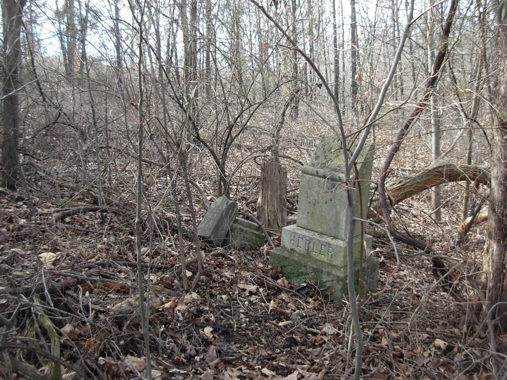
| Description | : | This farm is located on Rilius Road south of Jefferson City. John Christian Hedler acquired the property on 15 January 1858 in a land grant signed by President Buchanan. There are only two tombstones in this burial ground. They are tucked back into the trees and overgrown. The child's marker is detached from the base. |
frequently asked questions (FAQ):
-
Where is Hedler Cemetery?
Hedler Cemetery is located at Jefferson City, Cole County ,Missouri ,USA.
-
Hedler Cemetery cemetery's updated grave count on graveviews.com?
0 memorials
-
Where are the coordinates of the Hedler Cemetery?
Latitude: 38.4814000
Longitude: -92.2705700
Nearby Cemetories:
1. Johnston Cemetery
Brazito, Cole County, USA
Coordinate: 38.4928017, -92.2910995
2. Peace Lutheran Cemetery
Brazito, Cole County, USA
Coordinate: 38.4676600, -92.2889300
3. Sommerer Farm Cemetery
Brazito, Cole County, USA
Coordinate: 38.4546500, -92.2801800
4. Immanuel Lutheran Church Cemetery
Honey Creek, Cole County, USA
Coordinate: 38.4617500, -92.2432600
5. Islamic Cemetery of Mid Missouri
Jefferson City, Cole County, USA
Coordinate: 38.5117410, -92.2512620
6. Osage Bluff Methodist Cemetery
Osage Bluff, Cole County, USA
Coordinate: 38.4497910, -92.2513809
7. Clarenbach and Wright Cemetery
Brazito, Cole County, USA
Coordinate: 38.4482400, -92.2968000
8. Rouschelback Cemetery
Cole County, USA
Coordinate: 38.5116997, -92.2382965
9. Pleasant Hill Cemetery
Brazito, Cole County, USA
Coordinate: 38.4810300, -92.3224000
10. Arnhold Burial Ground
Brazito, Cole County, USA
Coordinate: 38.4478370, -92.3005870
11. Eberhardt Cemetery
Cole County, USA
Coordinate: 38.5257988, -92.2668991
12. Friedens Cemetery
Brazito, Cole County, USA
Coordinate: 38.4446182, -92.3035660
13. Zion Lutheran Cemetery
Cole County, USA
Coordinate: 38.5360985, -92.2521973
14. Raithel Cemetery
Brazito, Cole County, USA
Coordinate: 38.4420300, -92.3272400
15. Ott Burial Ground
Wardsville, Cole County, USA
Coordinate: 38.4955560, -92.1930280
16. Gordon Cemetery
Lohman, Cole County, USA
Coordinate: 38.5370900, -92.3158100
17. Eilenstein Burial Ground
Cole County, USA
Coordinate: 38.5477600, -92.2352200
18. Old Catholic Cemetery
Jefferson City, Cole County, USA
Coordinate: 38.5358009, -92.3321991
19. Saint Joseph Cemetery
Stringtown, Cole County, USA
Coordinate: 38.5361110, -92.3320720
20. Enloe Cemetery
Wardsville, Cole County, USA
Coordinate: 38.4780360, -92.1772050
21. Johannes Lumpe Gravesite
Jefferson City, Cole County, USA
Coordinate: 38.5446300, -92.2210100
22. Saint Stanislaus Catholic Church Cemetery
Wardsville, Cole County, USA
Coordinate: 38.4863450, -92.1756730
23. Fowler Farm Burial Ground
Bass, Cole County, USA
Coordinate: 38.4193750, -92.3235020
24. Saint Johns Lutheran Church Cemetery
Stringtown, Cole County, USA
Coordinate: 38.5192986, -92.3526993