
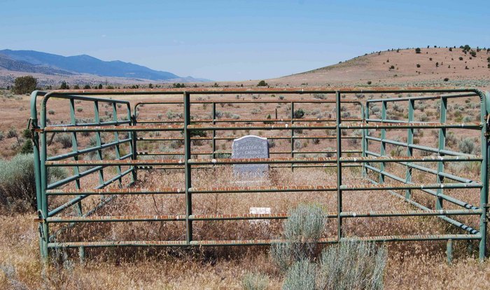
| Memorials | : | 0 |
| Location | : | Mount Vernon, Grant County, USA |
| Coordinate | : | 44.4228060, -119.1501540 |
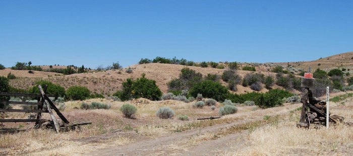
| Description | : | West of Mount Vernon turn right/north on Happy Valley Lane and go .4 mile and on the right is a barbed wire gate and go through the gate and park. Walk up the hill to the left and then north on the hill to the grave. This is on private property and permission must be obtained from the owner. |
frequently asked questions (FAQ):
-
Where is Hester A Lemons Grave?
Hester A Lemons Grave is located at Happy Valley Road (County Road 46) Mount Vernon, Grant County ,Oregon , 97865USA.
-
Hester A Lemons Grave cemetery's updated grave count on graveviews.com?
0 memorials
-
Where are the coordinates of the Hester A Lemons Grave?
Latitude: 44.4228060
Longitude: -119.1501540
Nearby Cemetories:
1. Fletcher Cemetery
Mount Vernon, Grant County, USA
Coordinate: 44.4063988, -119.1085968
2. Ingle Cemetery
Mount Vernon, Grant County, USA
Coordinate: 44.4091988, -119.0947037
3. Moon Creek Cemetery
Mount Vernon, Grant County, USA
Coordinate: 44.4291992, -119.2469025
4. Rest Lawn Cemetery
John Day, Grant County, USA
Coordinate: 44.4249992, -118.9617004
5. Cummings Cemetery
Mount Vernon, Grant County, USA
Coordinate: 44.4398000, -119.3452000
6. Saint Andrews Cemetery
Canyon City, Grant County, USA
Coordinate: 44.3913994, -118.9456024
7. Canyon City Cemetery
Canyon City, Grant County, USA
Coordinate: 44.3925018, -118.9403000
8. Boot Hill Cemetery
Canyon City, Grant County, USA
Coordinate: 44.3927994, -118.9372025
9. Fox Valley Cemetery
Grant County, USA
Coordinate: 44.6375008, -119.1513977
10. Aldrich Gravesite
Grant County, USA
Coordinate: 44.4528008, -119.4499969
11. Southworth Cemetery
Grant County, USA
Coordinate: 44.1885986, -118.9860992
12. Johnson Children Burials
Long Creek, Grant County, USA
Coordinate: 44.7131690, -119.1066030
13. Long Creek Cemetery
Long Creek, Grant County, USA
Coordinate: 44.7172012, -119.0777969
14. Dayville Cemetery
Dayville, Grant County, USA
Coordinate: 44.4834222, -119.5748805
15. McHaley Cemetery
Prairie City, Grant County, USA
Coordinate: 44.4618988, -118.7169037
16. Prairie City Cemetery
Prairie City, Grant County, USA
Coordinate: 44.4566994, -118.7027969
17. Hamilton Cemetery
Hamilton, Grant County, USA
Coordinate: 44.7435989, -119.3167038
18. Galena Cemetery
Grant County, USA
Coordinate: 44.7083015, -118.8056030
19. Izee Cemetery
Izee, Grant County, USA
Coordinate: 44.0694008, -119.3902969
20. Hankins Cemetery
Silvies, Grant County, USA
Coordinate: 44.0256004, -118.9233017
21. Cottonwood Cemetery
Monument, Grant County, USA
Coordinate: 44.8127747, -119.4158936
22. Kilbride Cemetery
Ritter, Grant County, USA
Coordinate: 44.8434200, -118.9918300
23. Monument Cemetery
Monument, Grant County, USA
Coordinate: 44.8208008, -119.4235992
24. Spanish Gulch Cemetery
Wheeler County, USA
Coordinate: 44.4667015, -119.7722015