
| Memorials | : | 0 |
| Location | : | Mount Vernon, Grant County, USA |
| Coordinate | : | 44.4398000, -119.3452000 |
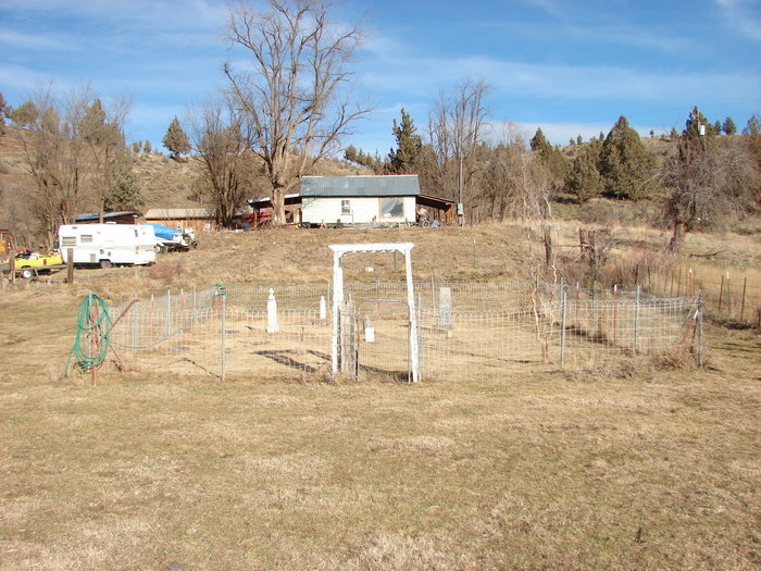
| Description | : | Located on private property on the north side of Highway 26 approximately 12 miles west of Mount Vernon. This area was formerly the Cummingsville area. T13S R28E S15 or S16 |
frequently asked questions (FAQ):
-
Where is Cummings Cemetery?
Cummings Cemetery is located at Mount Vernon, Grant County ,Oregon ,USA.
-
Cummings Cemetery cemetery's updated grave count on graveviews.com?
0 memorials
-
Where are the coordinates of the Cummings Cemetery?
Latitude: 44.4398000
Longitude: -119.3452000
Nearby Cemetories:
1. Moon Creek Cemetery
Mount Vernon, Grant County, USA
Coordinate: 44.4291992, -119.2469025
2. Aldrich Gravesite
Grant County, USA
Coordinate: 44.4528008, -119.4499969
3. Hester A Lemons Grave
Mount Vernon, Grant County, USA
Coordinate: 44.4228060, -119.1501540
4. Dayville Cemetery
Dayville, Grant County, USA
Coordinate: 44.4834222, -119.5748805
5. Fletcher Cemetery
Mount Vernon, Grant County, USA
Coordinate: 44.4063988, -119.1085968
6. Ingle Cemetery
Mount Vernon, Grant County, USA
Coordinate: 44.4091988, -119.0947037
7. Fox Valley Cemetery
Grant County, USA
Coordinate: 44.6375008, -119.1513977
8. Rest Lawn Cemetery
John Day, Grant County, USA
Coordinate: 44.4249992, -118.9617004
9. Saint Andrews Cemetery
Canyon City, Grant County, USA
Coordinate: 44.3913994, -118.9456024
10. Canyon City Cemetery
Canyon City, Grant County, USA
Coordinate: 44.3925018, -118.9403000
11. Boot Hill Cemetery
Canyon City, Grant County, USA
Coordinate: 44.3927994, -118.9372025
12. Hamilton Cemetery
Hamilton, Grant County, USA
Coordinate: 44.7435989, -119.3167038
13. Spanish Gulch Cemetery
Wheeler County, USA
Coordinate: 44.4667015, -119.7722015
14. Johnson Children Burials
Long Creek, Grant County, USA
Coordinate: 44.7131690, -119.1066030
15. Mary Waterman Burial Site
Mitchell, Wheeler County, USA
Coordinate: 44.4727402, -119.8117371
16. Frederic Arnecke Burial Site
Wheeler County, USA
Coordinate: 44.4740700, -119.8121100
17. Long Creek Cemetery
Long Creek, Grant County, USA
Coordinate: 44.7172012, -119.0777969
18. Buckhorn Cemetery
Mitchell, Wheeler County, USA
Coordinate: 44.6240730, -119.7498810
19. John Calbreath Gravesite
Paulina, Crook County, USA
Coordinate: 44.2064500, -119.7024300
20. Southworth Cemetery
Grant County, USA
Coordinate: 44.1885986, -118.9860992
21. Izee Cemetery
Izee, Grant County, USA
Coordinate: 44.0694008, -119.3902969
22. Cottonwood Cemetery
Monument, Grant County, USA
Coordinate: 44.8127747, -119.4158936
23. Monument Cemetery
Monument, Grant County, USA
Coordinate: 44.8208008, -119.4235992
24. Camp Watson Cemetery
Mitchell, Wheeler County, USA
Coordinate: 44.4844437, -119.8994675