
| Memorials | : | 0 |
| Location | : | Monument, Grant County, USA |
| Coordinate | : | 44.8127747, -119.4158936 |
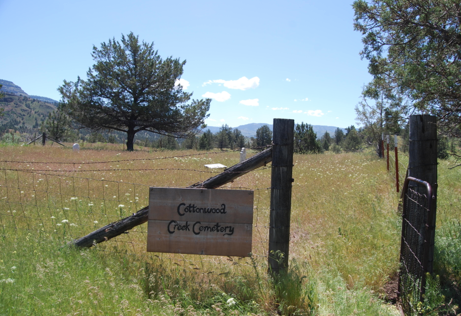
| Description | : | Pioneer Cemetery about 1 mile east of Monument and south of Highway 402 across Cottonwood Creek on private property. When a new cemetery was established in the town of Monument on property donated by Sarah Jane (Minkler) Vilott Wilson (later married Willis Jenks), these graves were not moved as the locals were afraid if they opened the graves of those who died of diptheria in 1879 that they might also get diptheria. T9S R27E S12 NOTE: At some point, this cemetery was vandalized and the headstones thrown over the bank according to Gary Adams, the current owner. Someone has tried... Read More |
frequently asked questions (FAQ):
-
Where is Cottonwood Cemetery?
Cottonwood Cemetery is located at Monument, Grant County ,Oregon ,USA.
-
Cottonwood Cemetery cemetery's updated grave count on graveviews.com?
0 memorials
-
Where are the coordinates of the Cottonwood Cemetery?
Latitude: 44.8127747
Longitude: -119.4158936
Nearby Cemetories:
1. Monument Cemetery
Monument, Grant County, USA
Coordinate: 44.8208008, -119.4235992
2. Cupper Canyon Cemetery
Monument, Grant County, USA
Coordinate: 44.8374300, -119.5015100
3. Hamilton Cemetery
Hamilton, Grant County, USA
Coordinate: 44.7435989, -119.3167038
4. Dickerson Ranch Cemetery
Ritter, Grant County, USA
Coordinate: 44.8875008, -119.1402969
5. Ritter Cemetery
Ritter, Grant County, USA
Coordinate: 44.9117012, -119.1481018
6. Haystack Cemetery
Wheeler County, USA
Coordinate: 44.8800011, -119.7352982
7. Johnson Children Burials
Long Creek, Grant County, USA
Coordinate: 44.7131690, -119.1066030
8. Fox Valley Cemetery
Grant County, USA
Coordinate: 44.6375008, -119.1513977
9. Long Creek Cemetery
Long Creek, Grant County, USA
Coordinate: 44.7172012, -119.0777969
10. Walton Ranch Cemetery
Grant County, USA
Coordinate: 44.8675499, -119.0265656
11. Spray Cemetery
Spray, Wheeler County, USA
Coordinate: 44.8471985, -119.8110962
12. Kilbride Cemetery
Ritter, Grant County, USA
Coordinate: 44.8434200, -118.9918300
13. Buckhorn Cemetery
Mitchell, Wheeler County, USA
Coordinate: 44.6240730, -119.7498810
14. Dayville Cemetery
Dayville, Grant County, USA
Coordinate: 44.4834222, -119.5748805
15. Winlock Cemetery
Winlock, Wheeler County, USA
Coordinate: 44.9124985, -119.8985977
16. Aldrich Gravesite
Grant County, USA
Coordinate: 44.4528008, -119.4499969
17. Cummings Cemetery
Mount Vernon, Grant County, USA
Coordinate: 44.4398000, -119.3452000
18. Moon Creek Cemetery
Mount Vernon, Grant County, USA
Coordinate: 44.4291992, -119.2469025
19. Hardman Cemetery
Hardman, Morrow County, USA
Coordinate: 45.1689987, -119.6859970
20. Lonerock Cemetery
Lonerock, Gilliam County, USA
Coordinate: 45.0710983, -119.8574982
21. Richmond Cemetery
Richmond, Wheeler County, USA
Coordinate: 44.7311096, -119.9911118
22. Rhea Creek Cemetery
Morrow County, USA
Coordinate: 45.2219009, -119.5410995
23. Spanish Gulch Cemetery
Wheeler County, USA
Coordinate: 44.4667015, -119.7722015
24. Richmond Cemetery
Wheeler County, USA
Coordinate: 44.7296982, -120.0105972