
| Memorials | : | 7 |
| Location | : | Mount Carroll, Carroll County, USA |
| Coordinate | : | 42.0578651, -90.0461960 |
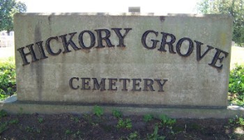
| Description | : | The Hickory Grove Cemetery is located in the small village of Wacker, Section 21, Mt. Carroll Township, Carroll County, Illinois. It is either on or very near the Wacker Road and is a churchyard cemetery. The photo of the cemetery sign was taken by Leroy Getz. The U.S. Geological Survey (USGS) Geographic Names Information System (GNIS) feature ID for the cemetery is 1785452 (Wacker Cemetery / German Baptist Cemetery / Hickory Grove Cemetery). |
frequently asked questions (FAQ):
-
Where is Hickory Grove Cemetery?
Hickory Grove Cemetery is located at Wacker Road Mount Carroll, Carroll County ,Illinois , 61053USA.
-
Hickory Grove Cemetery cemetery's updated grave count on graveviews.com?
6 memorials
-
Where are the coordinates of the Hickory Grove Cemetery?
Latitude: 42.0578651
Longitude: -90.0461960
Nearby Cemetories:
1. Sipe Cemetery
Mount Carroll, Carroll County, USA
Coordinate: 42.0450900, -90.0226600
2. Center Hill Cemetery
Center Hill, Carroll County, USA
Coordinate: 42.0813904, -90.0425034
3. Free Family Cemetery
Mount Carroll Township, Carroll County, USA
Coordinate: 42.0907590, -90.0767000
4. Carroll County Farm Cemetery
Mount Carroll, Carroll County, USA
Coordinate: 42.0722050, -89.9848680
5. Spring Lake Cemetery
Savanna, Carroll County, USA
Coordinate: 42.0503235, -90.1111069
6. Argo Cemetery
Argo Fay, Carroll County, USA
Coordinate: 42.0042480, -90.0170160
7. Oak Hill Cemetery
Mount Carroll, Carroll County, USA
Coordinate: 42.1033287, -89.9861069
8. Saint John the Baptist Catholic Cemetery
Savanna, Carroll County, USA
Coordinate: 42.0793991, -90.1280975
9. Trinity Lutheran Church Cemetery
Mount Carroll, Carroll County, USA
Coordinate: 42.0505600, -89.9588928
10. Savanna Township Cemetery
Savanna, Carroll County, USA
Coordinate: 42.0791702, -90.1297226
11. Daggert Cemetery
Mount Carroll, Carroll County, USA
Coordinate: 42.0377808, -89.9583282
12. Woodland Brethren Cemetery
Mount Carroll, Carroll County, USA
Coordinate: 42.1277809, -89.9877777
13. Oakville Cemetery
Mount Carroll, Carroll County, USA
Coordinate: 42.0501862, -89.9262314
14. Black Oak Cemetery
Chadwick, Carroll County, USA
Coordinate: 42.0122185, -89.9372177
15. Lower York Cemetery
Thomson, Carroll County, USA
Coordinate: 41.9588890, -90.0555573
16. Arnolds Grove Cemetery
Carroll County, USA
Coordinate: 42.1283302, -89.9436111
17. Hope Brethren Cemetery
Chadwick, Carroll County, USA
Coordinate: 42.0116855, -89.9176153
18. Arnolds Grove Dunkard Cemetery
Mount Carroll, Carroll County, USA
Coordinate: 42.1338610, -89.9436900
19. Evergreen Cemetery
Sabula, Jackson County, USA
Coordinate: 42.0966682, -90.1913910
20. Saint Peters Cemetery
Sabula, Jackson County, USA
Coordinate: 42.0844002, -90.1988983
21. Canada Hollow Cemetery
Miles, Jackson County, USA
Coordinate: 42.0553017, -90.2193985
22. Zion Cemetery
Mount Carroll, Carroll County, USA
Coordinate: 42.1841698, -90.0847168
23. Hauntown Cemetery
Elk River Junction, Clinton County, USA
Coordinate: 41.9889153, -90.1973505
24. Smith Cemetery
Clinton County, USA
Coordinate: 41.9742012, -90.1949997