
| Memorials | : | 0 |
| Location | : | Clifton, Bristol Unitary Authority, England |
| Coordinate | : | 51.4512800, -2.6216000 |
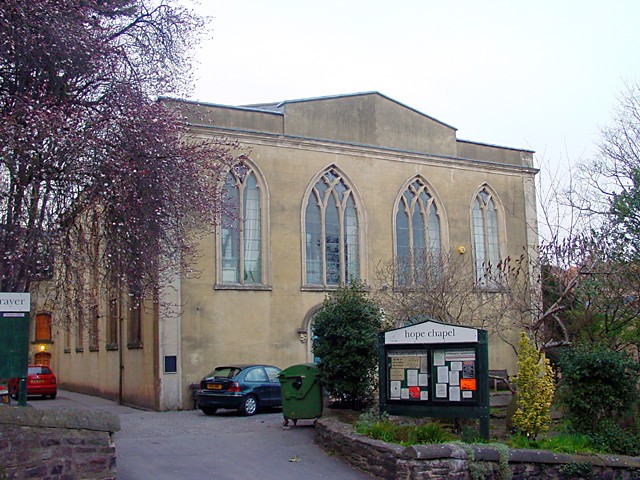
| Description | : | Two Scottish evangelical Calvinists in 1784 named Lady Henrietta Hope (c.1750–1786) and Lady Willielma Glenorchy (1741–1786) visited the Hotwells spa in Bristol, but were disappointed to find that the only place of worship was the Pembroke Chapel, which was located in Clifton a half mile up a steep hill. This led them to fund the building of a new chapel, more conveniently located near the spa. Unfortunately Lady Hope died before work on the new chapel had started, but she left her friend with £2,500 to ensure that it was built. Construction began in 1786, but Lady Glenorchy also died... Read More |
frequently asked questions (FAQ):
-
Where is Hope Chapel?
Hope Chapel is located at Hope Chapel Hill Clifton, Bristol Unitary Authority ,Bristol , B58 4NDEngland.
-
Hope Chapel cemetery's updated grave count on graveviews.com?
0 memorials
-
Where are the coordinates of the Hope Chapel?
Latitude: 51.4512800
Longitude: -2.6216000
Nearby Cemetories:
1. St. Andrew's Churchyard
Clifton, Bristol Unitary Authority, England
Coordinate: 51.4543810, -2.6147460
2. Christ Church Cemetery
Clifton, Bristol Unitary Authority, England
Coordinate: 51.4576220, -2.6200000
3. Clifton Cathedral
Clifton, Bristol Unitary Authority, England
Coordinate: 51.4596870, -2.6163140
4. Bristol Cathedral
Bristol, Bristol Unitary Authority, England
Coordinate: 51.4517059, -2.6007321
5. St. Mark's Church
Bristol, Bristol Unitary Authority, England
Coordinate: 51.4528770, -2.5999610
6. St Paul's Churchyard
Bedminster, Bristol Unitary Authority, England
Coordinate: 51.4452800, -2.5989500
7. St. Michael on the Mount Without Churchyard
Bristol, Bristol Unitary Authority, England
Coordinate: 51.4571510, -2.5984070
8. Hebron Road Burial Ground
Bristol, Bristol Unitary Authority, England
Coordinate: 51.4400610, -2.6041020
9. Church of St John the Baptist
Bristol, Bristol Unitary Authority, England
Coordinate: 51.4559460, -2.5950320
10. St Stephen's Churchyard
Bristol, Bristol Unitary Authority, England
Coordinate: 51.4535380, -2.5937270
11. All Saints Church
Bristol, Bristol Unitary Authority, England
Coordinate: 51.4546990, -2.5932550
12. St John the Baptist Church Demolished
Bedminster, Bristol Unitary Authority, England
Coordinate: 51.4400110, -2.5982980
13. St Nicholas Churchyard
Bristol, Bristol Unitary Authority, England
Coordinate: 51.4539170, -2.5923050
14. St. James Priory
Bristol, Bristol Unitary Authority, England
Coordinate: 51.4585220, -2.5936690
15. St. James Churchyard
Bristol, Bristol Unitary Authority, England
Coordinate: 51.4585510, -2.5932310
16. Holy Trinity Church
Bristol, Bristol Unitary Authority, England
Coordinate: 51.4559548, -2.5915587
17. Quaker Burial Ground
Redcliffe, Bristol Unitary Authority, England
Coordinate: 51.4486700, -2.5905900
18. Broadmead Baptist Church
Bristol, Bristol Unitary Authority, England
Coordinate: 51.4575500, -2.5915500
19. St Mary the Virgin Churchyard
Redcliffe, Bristol Unitary Authority, England
Coordinate: 51.4482800, -2.5895460
20. St. Peter's Churchyard
Bristol, Bristol Unitary Authority, England
Coordinate: 51.4553560, -2.5896930
21. All Saints Churchyard
Long Ashton, North Somerset Unitary Authority, England
Coordinate: 51.4358100, -2.6439400
22. Temple Churchyard
Bristol, Bristol Unitary Authority, England
Coordinate: 51.4520010, -2.5868870
23. Temple Church Churchyard
Redcliffe, Bristol Unitary Authority, England
Coordinate: 51.4521160, -2.5867630
24. Black Friars Priory
Bristol, Bristol Unitary Authority, England
Coordinate: 51.4572220, -2.5877780