
| Memorials | : | 2 |
| Location | : | Bedminster, Bristol Unitary Authority, England |
| Website | : | churchdb.gukutils.org.uk/GLS1959.php |
| Coordinate | : | 51.4400110, -2.5982980 |
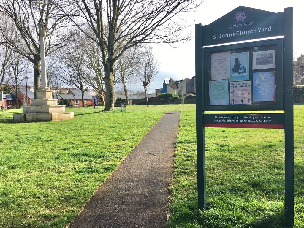
| Description | : | There have been at least three churches built on this site - the first lasting from 1003 to 1645, the second from 1663 to 1854, and the third from 1855 to 1940. The most recent church was destroyed on 24 November 1940, when it was completely burned out by incendiary bombs during the Battle of Britain. These ruins remained until 1967, when the site was completely cleared, the tombs and headstones removed, and the grounds made into a small park. Although nothing remains of either the church or graveyard, there are burial records from 1656 to 1965 in the Bristol... Read More |
frequently asked questions (FAQ):
-
Where is St John the Baptist Church Demolished?
St John the Baptist Church Demolished is located at St John's Street / Church Road Bedminster, Bristol Unitary Authority ,Bristol ,England.
-
St John the Baptist Church Demolished cemetery's updated grave count on graveviews.com?
2 memorials
-
Where are the coordinates of the St John the Baptist Church Demolished?
Latitude: 51.4400110
Longitude: -2.5982980
Nearby Cemetories:
1. Hebron Road Burial Ground
Bristol, Bristol Unitary Authority, England
Coordinate: 51.4400610, -2.6041020
2. St Paul's Churchyard
Bedminster, Bristol Unitary Authority, England
Coordinate: 51.4452800, -2.5989500
3. Quaker Burial Ground
Redcliffe, Bristol Unitary Authority, England
Coordinate: 51.4486700, -2.5905900
4. St Mary the Virgin Churchyard
Redcliffe, Bristol Unitary Authority, England
Coordinate: 51.4482800, -2.5895460
5. Bristol Cathedral
Bristol, Bristol Unitary Authority, England
Coordinate: 51.4517059, -2.6007321
6. St. Mark's Church
Bristol, Bristol Unitary Authority, England
Coordinate: 51.4528770, -2.5999610
7. St Stephen's Churchyard
Bristol, Bristol Unitary Authority, England
Coordinate: 51.4535380, -2.5937270
8. Temple Churchyard
Bristol, Bristol Unitary Authority, England
Coordinate: 51.4520010, -2.5868870
9. Temple Church Churchyard
Redcliffe, Bristol Unitary Authority, England
Coordinate: 51.4521160, -2.5867630
10. St Nicholas Churchyard
Bristol, Bristol Unitary Authority, England
Coordinate: 51.4539170, -2.5923050
11. All Saints Church
Bristol, Bristol Unitary Authority, England
Coordinate: 51.4546990, -2.5932550
12. Church of St John the Baptist
Bristol, Bristol Unitary Authority, England
Coordinate: 51.4559460, -2.5950320
13. St. Peter's Churchyard
Bristol, Bristol Unitary Authority, England
Coordinate: 51.4553560, -2.5896930
14. Holy Trinity Church
Bristol, Bristol Unitary Authority, England
Coordinate: 51.4559548, -2.5915587
15. St Philip and St Jacob Churchyard
Bristol, Bristol Unitary Authority, England
Coordinate: 51.4545420, -2.5844690
16. St. Michael on the Mount Without Churchyard
Bristol, Bristol Unitary Authority, England
Coordinate: 51.4571510, -2.5984070
17. St. Andrew's Churchyard
Clifton, Bristol Unitary Authority, England
Coordinate: 51.4543810, -2.6147460
18. Broadmead Baptist Church
Bristol, Bristol Unitary Authority, England
Coordinate: 51.4575500, -2.5915500
19. Barton Road Jewish Cemetery
St Phillips, Bristol Unitary Authority, England
Coordinate: 51.4531400, -2.5779800
20. Hope Chapel
Clifton, Bristol Unitary Authority, England
Coordinate: 51.4512800, -2.6216000
21. Black Friars Priory
Bristol, Bristol Unitary Authority, England
Coordinate: 51.4572220, -2.5877780
22. Quakers Friars Burial Ground
Bristol, Bristol Unitary Authority, England
Coordinate: 51.4572220, -2.5877780
23. St. James Priory
Bristol, Bristol Unitary Authority, England
Coordinate: 51.4585220, -2.5936690
24. Redcross Street Burial Ground (Defunct)
Bristol Unitary Authority, England
Coordinate: 51.4563073, -2.5833100