
| Memorials | : | 4 |
| Location | : | Bronx, Bronx County, USA |
| Coordinate | : | 40.8103500, -73.8826760 |
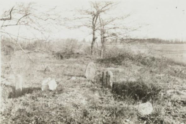
| Description | : | Oak Pt. Ave. bet. Hunts Pt. Ave. and Longfellow Ave., Drake St, Bronx, NY 10474 The Hunts Point Slave Burial Ground is located in the Hunts Point neighborhood of The Bronx within the grounds of the Joseph Rodman Drake Park, a few blocks from P.S. 48. The location is most likely in the south west location of the park near the willow tree.(Note: From primary history documents like wills, newspaper accounts and old maps, it turns out the cemetery was "across the road" from Drake Park- the Hunt, Leggett and Willett family burial plots that date back to colonial times.... Read More |
frequently asked questions (FAQ):
-
Where is Hunts Point Slave Burial Ground?
Hunts Point Slave Burial Ground is located at Oak Pt. Ave Bronx, Bronx County ,New York , 10474USA.
-
Hunts Point Slave Burial Ground cemetery's updated grave count on graveviews.com?
4 memorials
-
Where are the coordinates of the Hunts Point Slave Burial Ground?
Latitude: 40.8103500
Longitude: -73.8826760
Nearby Cemetories:
1. Joseph Rodman Drake Park
Bronx, Bronx County, USA
Coordinate: 40.8103447, -73.8825531
2. Corpus Christi Monastery
Bronx, Bronx County, USA
Coordinate: 40.8159170, -73.8902750
3. Bensonia Cemetery
Morrisania, Bronx County, USA
Coordinate: 40.8174070, -73.9124690
4. Saint Ann's Episcopal Church Graveyard
Bronx, Bronx County, USA
Coordinate: 40.8081100, -73.9167700
5. New York City Catholic Protectory Cemetery
Parkchester, Bronx County, USA
Coordinate: 40.8383510, -73.8599670
6. West Farms Soldier Cemetery
West Farms, Bronx County, USA
Coordinate: 40.8435826, -73.8793190
7. Old Presbyterian Church Cemetery
West Farms, Bronx County, USA
Coordinate: 40.8439960, -73.8797820
8. Berrien Island Cemetery
Astoria, Queens County, USA
Coordinate: 40.7842070, -73.9120700
9. Randalls Island Burial Ground
Randalls Island, New York County (Manhattan), USA
Coordinate: 40.7912970, -73.9226250
10. Rapelje Cemetery
Queens County, USA
Coordinate: 40.7827820, -73.9146340
11. Bowery Bay Cemetery (Defunct)
Queens, Queens County, USA
Coordinate: 40.7733730, -73.8849560
12. Lawrence Cemetery
Astoria, Queens County, USA
Coordinate: 40.7773800, -73.9056200
13. Riker-Lent Burial Ground
Astoria, Queens County, USA
Coordinate: 40.7734100, -73.8922120
14. Dutch Reformed Church Cemetery of Harlem (Defunct)
Harlem, New York County (Manhattan), USA
Coordinate: 40.8014950, -73.9317320
15. New York House of Refuge Grounds Cemetery
Manhattan, New York County (Manhattan), USA
Coordinate: 40.7931683, -73.9279023
16. William Lawrence Family Burial Ground
College Point, Queens County, USA
Coordinate: 40.7909680, -73.8388130
17. Saint Raymonds Roman Catholic Churchyard
Bronx, Bronx County, USA
Coordinate: 40.8421100, -73.8538400
18. Saint Fidelis Church Cemetery
College Point, Queens County, USA
Coordinate: 40.7848660, -73.8442450
19. Quaker Cemetery
Bronx, Bronx County, USA
Coordinate: 40.8378070, -73.8443860
20. Saint Raymond's Cemetery New
Bronx, Bronx County, USA
Coordinate: 40.8253300, -73.8333930
21. Saint Peters Episcopal Churchyard
Bronx, Bronx County, USA
Coordinate: 40.8388600, -73.8439500
22. Saint Andrews Episcopal Churchyard
Harlem, New York County (Manhattan), USA
Coordinate: 40.8066430, -73.9374220
23. Ferris Family Burying Ground
Bronx, Bronx County, USA
Coordinate: 40.8388300, -73.8422200
24. Methodist Church Cemetery (Defunct)
Westchester Square, Bronx County, USA
Coordinate: 40.8435020, -73.8486860