
| Memorials | : | 0 |
| Location | : | IJhorst, Staphorst Municipality, Netherlands |
| Coordinate | : | 52.6636200, 6.2851200 |
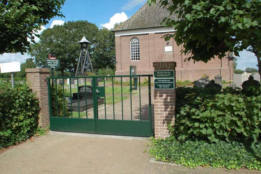
| Description | : | Staphorst is a village and commune 7 kilometres south of Meppel on the road to Zwolle. Ijhorst is a village in this commune about 4 kilometres north-east of Staphorst village on the road to Dewijk. The cemetery is in the centre of the village on the Dewijk road. Although it surrounds a small Protestant church it is a general cemetery. |
frequently asked questions (FAQ):
-
Where is Ijhorst General Cemetery?
Ijhorst General Cemetery is located at IJhorst, Staphorst Municipality ,Overijssel ,Netherlands.
-
Ijhorst General Cemetery cemetery's updated grave count on graveviews.com?
0 memorials
-
Where are the coordinates of the Ijhorst General Cemetery?
Latitude: 52.6636200
Longitude: 6.2851200

Nearby Cemetories:
1. De Wijk General Cemetery
De Wijk, De Wolden Municipality, Netherlands
Coordinate: 52.6679600, 6.2860500
2. Begraafplaats Berghuizen
Berghuizen, De Wolden Municipality, Netherlands
Coordinate: 52.7145874, 6.2876037
3. Ruinerwold General Cemetery
Ruinerwold, De Wolden Municipality, Netherlands
Coordinate: 52.7133700, 6.2489200
4. Oud-Avereest General Cemetery
Oud-Avereest, Hardenberg Municipality, Netherlands
Coordinate: 52.6200500, 6.3711200
5. Israëlitische Begraafplaats
Meppel, Meppel Municipality, Netherlands
Coordinate: 52.7134680, 6.1898920
6. Rouveen New General Cemetery
Rouveen, Staphorst Municipality, Netherlands
Coordinate: 52.6157100, 6.1842900
7. Nijeveen Old Protestant Churchyard
Nijeveen, Meppel Municipality, Netherlands
Coordinate: 52.7324800, 6.1639500
8. Joodse Begraafplaats
Dedemsvaart, Hardenberg Municipality, Netherlands
Coordinate: 52.6104000, 6.4391940
9. Begraafplaats Havelte
Havelte, Westerveld Municipality, Netherlands
Coordinate: 52.7741442, 6.2472284
10. Joodse Begraafplaats
Ruinen, De Wolden Municipality, Netherlands
Coordinate: 52.7654800, 6.3722500
11. Dedemsvaart Roman Catholic cemetery
Dedemsvaart, Hardenberg Municipality, Netherlands
Coordinate: 52.6064800, 6.4597800
12. Nieuwe begraafplaats
Hoogeveen, Hoogeveen Municipality, Netherlands
Coordinate: 52.7159100, 6.4674200
13. Dedemsvaart Achterveld Cemetery
Dedemsvaart, Hardenberg Municipality, Netherlands
Coordinate: 52.6146500, 6.4740300
14. Joodse Begraafplaats Zuidweg
Hoogeveen, Hoogeveen Municipality, Netherlands
Coordinate: 52.7171500, 6.4715800
15. Joodse Begraafplaats
Zwartsluis, Zwartewaterland Municipality, Netherlands
Coordinate: 52.6413820, 6.0723750
16. Oude Joodse Begraafplaats
Hoogeveen Municipality, Netherlands
Coordinate: 52.7254000, 6.4816800
17. Begraafplaats Van Stolkspark
Hasselt, Zwartewaterland Municipality, Netherlands
Coordinate: 52.5897916, 6.0961902
18. Joodse begraafplaats
Hasselt, Zwartewaterland Municipality, Netherlands
Coordinate: 52.5929800, 6.0923800
19. Welsum Algemene Begraafplaats
Dalfsen, Dalfsen Municipality, Netherlands
Coordinate: 52.5177100, 6.2782500
20. Kallenkote Old General Cemetery
Kallenkote, Steenwijkerland Municipality, Netherlands
Coordinate: 52.7862800, 6.1530100
21. Joodse Begraafplaats
Dalfsen Municipality, Netherlands
Coordinate: 52.5173860, 6.2679170
22. Algemene Begraafplaats De Nieuwe Landen
Kallenkote, Steenwijkerland Municipality, Netherlands
Coordinate: 52.7867100, 6.1512500
23. Giethoorn Kerkhof
Giethoorn, Steenwijkerland Municipality, Netherlands
Coordinate: 52.7397600, 6.0764900
24. Steenwijk General Cemetery
Steenwijk, Steenwijkerland Municipality, Netherlands
Coordinate: 52.7863900, 6.1284800